TopoQuest Logo
Do you find TopoQuest useful?
Help keep TopoQuest running and adding new maps/features by donating!
Bitcoin:  19c7KJd3qBynnjoSw5npx9KScwjBe4ifkT
Litecoin:  LXs6TkuXGGXo1vDsWCkWVdjQX94eUKd6ui
Home View Maps Find Maps Find Places Resources & Links


Society Hill, South Carolina Topographic Map

USGS Map Title: Society Hill, SC
USGS Map MRC: 34079E7
DRG (GeoTIFF) Download: o34079e7.tif


Neighboring USGS Topographic Map Quads:


  Cheraw, SC  
34079F8
 

  Wallace, SC  
34079F7
 

  Bennettsville North, SC  
34079F6
 

  Cash, SC  
34079E8
 

  Society Hill, SC  
34079E7
 

  Bennettsville South, SC  
34079E6
 

  Dovesville, SC  
34079D8
 

  Mont Clare, SC  
34079D7
 

  Drake, SC  
34079D6


Map MRC Location:

N35°
W80°
N35°
W79°
H8 H7 H6 H5 H4 H3 H2 H1
G8 G7 G6 G5 G4 G3 G2 G1
F8 F7 F6 F5 F4 F3 F2 F1
E8 E7 E6 E5 E4 E3 E2 E1
D8 D7 D6 D5 D4 D3 D2 D1
C8 C7 C6 C5 C4 C3 C2 C1
B8 B7 B6 B5 B4 B3 B2 B1
A8 A7 A6 A5 A4 A3 A2 A1
N34°
W80°
N34°
W79°

Society Hill, SC USGS 1:24K Topographic Map Preview:
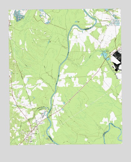
Society Hill, SC USGS Topographic Map
Click on map above to begin viewing in our Map Viewer.

This topographic map contains these locations and features:
Feature Name Type Latitude Longitude GNIS ID View Map
Becker PondReservoirN34.6248°W79.7643°1240290View Map
Becker Pond Dam D-3449DamN34.6235°W79.7665°1240289View Map
Boggy BranchStreamN34.5049°W79.8720°1235599View Map
Cash LakeLakeN34.5950°W79.8304°1221382View Map
Cashs Depot (historical)LocaleN34.6210°W79.8726°1235607View Map
Cedar CreekStreamN34.5321°W79.8306°1247201View Map
Colonel Kolbs TombCemeteryN34.5368°W79.8270°1244042View Map
Crooked CreekStreamN34.5813°W79.8095°983762View Map
Darlington County Fire District Station 11BuildingN34.5100°W79.8547°2578620View Map
Davis FieldParkN34.5057°W79.8570°1240848View Map
Dyers HillPopulated PlaceN34.5829°W79.7609°1232707View Map
Dyers Hill ChurchChurchN34.5840°W79.7631°1247584View Map
Dyers Hill SchoolSchoolN34.5838°W79.7628°1232708View Map
Evans Mill (historical)LocaleN34.5229°W79.8542°1235648View Map
Gardners BluffCliffN34.6077°W79.7817°1232720View Map
Goose MarshSwampN34.5217°W79.7995°1232723View Map
Harris Creek School (historical)SchoolN34.5138°W79.8670°1235673View Map
Hugh CreekStreamN34.5585°W79.8223°1223382View Map
Klopman Mill PondReservoirN34.5291°W79.8359°1238475View Map
Linton School (historical)SchoolN34.5621°W79.8731°1235695View Map
Mares LakeLakeN34.6136°W79.7996°1224308View Map
Mathesons Mill (historical)LocaleN34.5863°W79.7698°1232757View Map
Mathesons MillpondLakeN34.5861°W79.7682°1246553View Map
Naked CreekStreamN34.6149°W79.7770°1224917View Map
Noname 16028 D-3538 DamDamN34.5285°W79.8365°1238474View Map
Plumfield LandingPopulated PlaceN34.5013°W79.8248°1227966View Map
Reedys BranchStreamN34.5488°W79.8245°1250330View Map
Rosenwald SchoolSchoolN34.5035°W79.8515°1250471View Map
Saint Davids AcademySchoolN34.5052°W79.8567°1240972View Map
Saint Marks ChurchChurchN34.6096°W79.7640°1226197View Map
Saint Marks School (historical)SchoolN34.6096°W79.7634°1232789View Map
Society HillPopulated PlaceN34.5127°W79.8509°1250950View Map
Society Hill Police DepartmentBuildingN34.5098°W79.8546°2734279View Map
Society Hill Rescue SquadBuildingN34.5098°W79.8548°2739564View Map
Sparks Ferry (historical)CrossingN34.5315°W79.8303°1232798View Map
Spot Mill CreekStreamN34.5332°W79.8437°1250992View Map
Town of Society HillCivilN34.5099°W79.8539°2407364View Map
Trinity CemeteryCemeteryN34.5129°W79.8537°1241009View Map
Trinity Episcopal ChurchChurchN34.5129°W79.8537°1241011View Map
Welch Neck Memorial BridgeBridgeN34.5254°W79.8328°1252246View Map
Welsh NeckCapeN34.5254°W79.8206°1227470View Map
Welsh Neck (historical)Populated PlaceN34.5613°W79.8081°1232803View Map
Welsh Neck Baptist ChurchChurchN34.5121°W79.8501°1241016View Map
Welsh Neck CemeteryCemeteryN34.5118°W79.8501°1241017View Map

Note: Coordinates in the location and feature list above are referenced to NAD83 datum.


Copyright (C) 2008-2025 Ryan Niemi / Sunset Dynamics ... All Rights Reserved