TopoQuest Logo
Do you find TopoQuest useful?
Help keep TopoQuest running and adding new maps/features by donating!
Bitcoin:  19c7KJd3qBynnjoSw5npx9KScwjBe4ifkT
Litecoin:  LXs6TkuXGGXo1vDsWCkWVdjQX94eUKd6ui
Home View Maps Find Maps Find Places Resources & Links


Doxey, Oklahoma Topographic Map

USGS Map Title: Doxey, OK
USGS Map MRC: 35099C5
DRG (GeoTIFF) Download: o35099c5.tif


Neighboring USGS Topographic Map Quads:


  Berlin, OK  
35099D6
 

  Baker Lake, OK  
35099D5
 

  Elk City, OK  
35099D4
 

  Sayre, OK  
35099C6
 

  Doxey, OK  
35099C5
 

  Hocker, OK  
35099C4
 

  Delhi, OK  
35099B6
 

  Carter West, OK  
35099B5
 

  Carter East, OK  
35099B4


Map MRC Location:

N36°
W100°
N36°
W99°
H8 H7 H6 H5 H4 H3 H2 H1
G8 G7 G6 G5 G4 G3 G2 G1
F8 F7 F6 F5 F4 F3 F2 F1
E8 E7 E6 E5 E4 E3 E2 E1
D8 D7 D6 D5 D4 D3 D2 D1
C8 C7 C6 C5 C4 C3 C2 C1
B8 B7 B6 B5 B4 B3 B2 B1
A8 A7 A6 A5 A4 A3 A2 A1
N35°
W100°
N35°
W99°

Doxey, OK USGS 1:24K Topographic Map Preview:
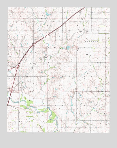
Doxey, OK USGS Topographic Map
Click on map above to begin viewing in our Map Viewer.

This topographic map contains these locations and features:
Feature Name Type Latitude Longitude GNIS ID View Map
City of SayreCivilN35.2951°W99.6092°2411836View Map
Coffee Bean CreekStreamN35.3251°W99.5732°1091535View Map
Deep CreekStreamN35.2762°W99.5923°1091993View Map
DoxeyPopulated PlaceN35.3242°W99.5832°1100364View Map
Doxey SchoolSchoolN35.3445°W99.5773°1092180View Map
Elk City Oil FieldOilfieldN35.2692°W99.5340°1092529View Map
MerrittPopulated PlaceN35.3698°W99.5054°1100628View Map
North Fork Correctional FacilityBuildingN35.2938°W99.6130°2766637View Map
O H Reid DamDamN35.2567°W99.5554°1757807View Map
O H Reid ReservoirReservoirN35.2567°W99.5554°1757808View Map
Old Doxey CemeteryCemeteryN35.3276°W99.5784°2704471View Map
Sayre - Doxey CemeteryCemeteryN35.3134°W99.5952°1097860View Map
Sayre CemeteryCemeteryN35.2909°W99.6132°1097859View Map
Spring CreekStreamN35.3551°W99.5862°1098418View Map
Timber CreekStreamN35.2734°W99.5734°1098901View Map
Timber Creek Site 1 DamDamN35.3334°W99.5554°1757797View Map
Timber Creek Site 1 ReservoirReservoirN35.3334°W99.5554°1757798View Map
Timber Creek Site 2 DamDamN35.3617°W99.5537°1757799View Map
Timber Creek Site 2 ReservoirReservoirN35.3617°W99.5537°1757800View Map
Timber Creek Site 3 DamDamN35.3634°W99.5787°1757823View Map
Timber Creek Site 3 ReservoirReservoirN35.3634°W99.5787°1757824View Map
Whitledge Number 1 DamDamN35.2767°W99.5470°1756036View Map
Whitledge Number 1 ReservoirReservoirN35.2795°W99.5465°1756037View Map
Whitledge Number 2 DamDamN35.2701°W99.5454°1757817View Map
Whitledge Number 2 ReservoirReservoirN35.2719°W99.5466°1757818View Map

Note: Coordinates in the location and feature list above are referenced to NAD83 datum.


Copyright (C) 2008-2025 Ryan Niemi / Sunset Dynamics ... All Rights Reserved