TopoQuest Logo
Do you find TopoQuest useful?
Help keep TopoQuest running and adding new maps/features by donating!
Bitcoin:  19c7KJd3qBynnjoSw5npx9KScwjBe4ifkT
Litecoin:  LXs6TkuXGGXo1vDsWCkWVdjQX94eUKd6ui
Home View Maps Find Maps Find Places Resources & Links


Berlin, Oklahoma Topographic Map

USGS Map Title: Berlin, OK
USGS Map MRC: 35099D6
DRG (GeoTIFF) Download: o35099d6.tif


Neighboring USGS Topographic Map Quads:


  Dempsey, OK  
35099E7
 

  Cheyenne, OK  
35099E6
 

  Herring, OK  
35099E5
 

  Grimes, OK  
35099D7
 

  Berlin, OK  
35099D6
 

  Baker Lake, OK  
35099D5
 

  Prentiss, OK  
35099C7
 

  Sayre, OK  
35099C6
 

  Doxey, OK  
35099C5


Map MRC Location:

N36°
W100°
N36°
W99°
H8 H7 H6 H5 H4 H3 H2 H1
G8 G7 G6 G5 G4 G3 G2 G1
F8 F7 F6 F5 F4 F3 F2 F1
E8 E7 E6 E5 E4 E3 E2 E1
D8 D7 D6 D5 D4 D3 D2 D1
C8 C7 C6 C5 C4 C3 C2 C1
B8 B7 B6 B5 B4 B3 B2 B1
A8 A7 A6 A5 A4 A3 A2 A1
N35°
W100°
N35°
W99°

Berlin, OK USGS 1:24K Topographic Map Preview:
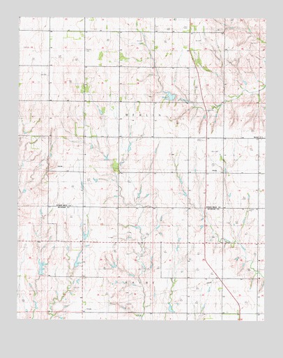
Berlin, OK USGS Topographic Map
Click on map above to begin viewing in our Map Viewer.

This topographic map contains these locations and features:
Feature Name Type Latitude Longitude GNIS ID View Map
Allison DamDamN35.4000°W99.7204°1757813View Map
Allison ReservoirReservoirN35.3992°W99.7202°1757814View Map
Baker DamDamN35.4550°W99.7470°1755416View Map
Baker ReservoirReservoirN35.4550°W99.7470°1755417View Map
BerlinPopulated PlaceN35.4506°W99.6254°1090014View Map
Berlin Volunteer Fire AssociationBuildingN35.4510°W99.6276°2658480View Map
D C Thetford DamDamN35.4117°W99.7170°1757805View Map
D C Thetford ReservoirReservoirN35.4100°W99.7160°1757806View Map
Marshall LakeReservoirN35.4678°W99.6733°1095157View Map
Mclaury Number 1 DamDamN35.3950°W99.7387°1757809View Map
Mclaury Number 1 ReservoirReservoirN35.3960°W99.7385°1757810View Map
Oknoname 129010 DamDamN35.4467°W99.6887°1755412View Map
Oknoname 129010 ReservoirReservoirN35.4467°W99.6887°1755413View Map
Rosehill CemeteryCemeteryN35.4868°W99.7169°1097451View Map
Sandstone Creek Site 16a DamDamN35.4650°W99.6720°1756479View Map
Sandstone Creek Site 16a ReservoirReservoirN35.4650°W99.6720°1756480View Map
Shotwell Number 1 DamDamN35.3934°W99.6920°1756030View Map
Shotwell Number 1 ReservoirReservoirN35.3937°W99.6923°1756031View Map
Shotwell Number 2 DamDamN35.3967°W99.7020°1756040View Map
Shotwell Number 2 ReservoirReservoirN35.3970°W99.7019°1756041View Map
Township of BerlinCivilN35.4862°W99.6920°1825390View Map

Note: Coordinates in the location and feature list above are referenced to NAD83 datum.


Copyright (C) 2008-2024 Ryan Niemi / Sunset Dynamics ... All Rights Reserved