TopoQuest Logo
Do you find TopoQuest useful?
Help keep TopoQuest running and adding new maps/features by donating!
Bitcoin:  19c7KJd3qBynnjoSw5npx9KScwjBe4ifkT
Litecoin:  LXs6TkuXGGXo1vDsWCkWVdjQX94eUKd6ui
Home View Maps Find Maps Find Places Resources & Links


Sayre, Oklahoma Topographic Map

USGS Map Title: Sayre, OK
USGS Map MRC: 35099C6
DRG (GeoTIFF) Download: o35099c6.tif


Neighboring USGS Topographic Map Quads:


  Grimes, OK  
35099D7
 

  Berlin, OK  
35099D6
 

  Baker Lake, OK  
35099D5
 

  Prentiss, OK  
35099C7
 

  Sayre, OK  
35099C6
 

  Doxey, OK  
35099C5
 

  Erick, OK  
35099B7
 

  Delhi, OK  
35099B6
 

  Carter West, OK  
35099B5


Map MRC Location:

N36°
W100°
N36°
W99°
H8 H7 H6 H5 H4 H3 H2 H1
G8 G7 G6 G5 G4 G3 G2 G1
F8 F7 F6 F5 F4 F3 F2 F1
E8 E7 E6 E5 E4 E3 E2 E1
D8 D7 D6 D5 D4 D3 D2 D1
C8 C7 C6 C5 C4 C3 C2 C1
B8 B7 B6 B5 B4 B3 B2 B1
A8 A7 A6 A5 A4 A3 A2 A1
N35°
W100°
N35°
W99°

Sayre, OK USGS 1:24K Topographic Map Preview:
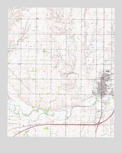
Sayre, OK USGS Topographic Map
Click on map above to begin viewing in our Map Viewer.

This topographic map contains these locations and features:
Feature Name Type Latitude Longitude GNIS ID View Map
Beckham CountyCivilN35.2687°W99.6819°1101792View Map
Beckham County JailBuildingN35.2906°W99.6363°2757868View Map
Beckham County Sheriff's OfficeBuildingN35.2905°W99.6367°2757704View Map
Beckham Mills Baptist Association ChurchChurchN35.3112°W99.6334°1809930View Map
Church of ChristChurchN35.2953°W99.6432°1809935View Map
First Baptist ChurchChurchN35.2959°W99.6401°1809934View Map
First Christian ChurchChurchN35.3087°W99.6409°1809932View Map
Hickey DamDamN35.3417°W99.6537°1756038View Map
Hickey ReservoirReservoirN35.3427°W99.6523°1756039View Map
Lone Oak CemeteryCemeteryN35.3208°W99.7378°2701804View Map
Lone Oak ChurchChurchN35.3198°W99.7359°1094910View Map
Long CreekStreamN35.2801°W99.6615°1094956View Map
New LibertyPopulated PlaceN35.3637°W99.7176°1100671View Map
New Victory ChurchChurchN35.3062°W99.7001°1095844View Map
Phillips DamDamN35.3584°W99.7287°1757819View Map
Phillips ReservoirReservoirN35.3580°W99.7292°1757820View Map
Robertson DamDamN35.3651°W99.6870°1756050View Map
Robertson ReservoirReservoirN35.3651°W99.6870°1756051View Map
Sacred Heart CemeteryCemeteryN35.3203°W99.6382°1777887View Map
Saint Mathews Catholic ChurchChurchN35.3006°W99.6418°1809933View Map
Sand CreekStreamN35.2795°W99.6515°1097766View Map
SayrePopulated PlaceN35.2912°W99.6401°1097858View Map
Sayre DivisionCivilN35.2609°W99.6485°1937842View Map
Sayre Elementary SchoolSchoolN35.3141°W99.6351°1819326View Map
Sayre Fire DepartmentBuildingN35.3017°W99.6397°2658470View Map
Sayre High SchoolSchoolN35.3137°W99.6330°1819323View Map
Sayre Memorial HospitalHospitalN35.3132°W99.6256°2695692View Map
Sayre Middle SchoolSchoolN35.3141°W99.6340°1819324View Map
Sayre Police DepartmentBuildingN35.3015°W99.6396°2757717View Map
Short CreekStreamN35.2912°W99.6326°1098020View Map
Sinor Emergency Medical ServiceBuildingN35.2915°W99.6429°2695827View Map
Southwest Oklahoma State UniversitySchoolN35.3112°W99.6351°1777886View Map
Thurman DamDamN35.3417°W99.7387°1757803View Map
Thurman ReservoirReservoirN35.3417°W99.7387°1757804View Map
Township of SayreCivilN35.3278°W99.6893°1825256View Map
Turkey CreekStreamN35.2695°W99.7015°1099046View Map
United Methodist ChurchChurchN35.3059°W99.6404°1809931View Map
Uptown Shopping CenterLocaleN35.3081°W99.6365°1763835View Map
W D Lakey 5ReservoirN35.2967°W99.6937°1756035View Map
W D Lakey 5 DamDamN35.2967°W99.6937°1756034View Map

Note: Coordinates in the location and feature list above are referenced to NAD83 datum.


Copyright (C) 2008-2024 Ryan Niemi / Sunset Dynamics ... All Rights Reserved