TopoQuest Logo
Do you find TopoQuest useful?
Help keep TopoQuest running and adding new maps/features by donating!
Bitcoin:  19c7KJd3qBynnjoSw5npx9KScwjBe4ifkT
Litecoin:  LXs6TkuXGGXo1vDsWCkWVdjQX94eUKd6ui
Home View Maps Find Maps Find Places Resources & Links


Drake, Kentucky Topographic Map

USGS Map Title: Drake, KY
USGS Map MRC: 36086G4
DRG (GeoTIFF) Download: o36086g4.tif


Neighboring USGS Topographic Map Quads:


  Rockfield, KY  
36086H5
 

  Bowling Green South, KY  
36086H4
 

  Polkville, KY  
36086H3
 

  Woodburn, KY  
36086G5
 

  Drake, KY  
36086G4
 

  Allen Springs, KY  
36086G3
 

  Franklin, KY  
36086F5
 

  Hickory Flat, KY  
36086F4
 

  Adolphus, KY  
36086F3


Map MRC Location:

N37°
W87°
N37°
W86°
H8 H7 H6 H5 H4 H3 H2 H1
G8 G7 G6 G5 G4 G3 G2 G1
F8 F7 F6 F5 F4 F3 F2 F1
E8 E7 E6 E5 E4 E3 E2 E1
D8 D7 D6 D5 D4 D3 D2 D1
C8 C7 C6 C5 C4 C3 C2 C1
B8 B7 B6 B5 B4 B3 B2 B1
A8 A7 A6 A5 A4 A3 A2 A1
N36°
W87°
N36°
W86°

Drake, KY USGS 1:24K Topographic Map Preview:
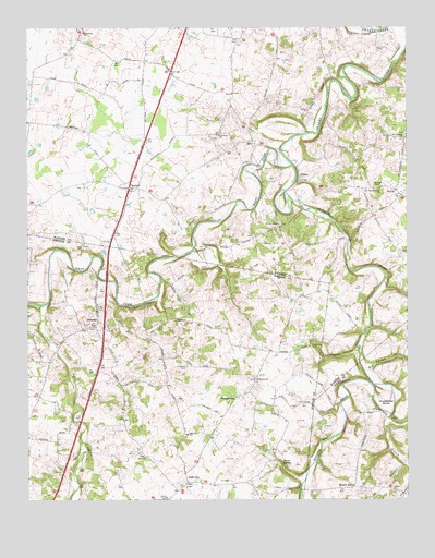
Drake, KY USGS Topographic Map
Click on map above to begin viewing in our Map Viewer.

This topographic map contains these locations and features:
Feature Name Type Latitude Longitude GNIS ID View Map
Barnes SchoolSchoolN36.7674°W86.4477°486388View Map
Big Spring BranchStreamN36.7839°W86.3892°487265View Map
BoycePopulated PlaceN36.8320°W86.3794°507565View Map
Boyce Wafer Farm AirportAirportN36.8116°W86.3802°517341View Map
Coldwater CemeteryCemeteryN36.7900°W86.4063°489803View Map
Coldwater HollowValleyN36.7892°W86.3923°489805View Map
DrakePopulated PlaceN36.8362°W86.4097°507874View Map
Gold CityPopulated PlaceN36.7545°W86.4475°508107View Map
Hams BranchStreamN36.7723°W86.3808°493663View Map
HillsdalePopulated PlaceN36.7970°W86.4764°508242View Map
Hopewell CemeteryCemeteryN36.7856°W86.4483°494518View Map
Horseshoe BendBendN36.7745°W86.3817°494599View Map
Jakes BranchStreamN36.8017°W86.4703°495151View Map
Lick CreekStreamN36.8014°W86.4953°496477View Map
Marthas ChapelChurchN36.8331°W86.3847°497594View Map
MatlockPopulated PlaceN36.8328°W86.4661°508558View Map
Middle Fork Drakes CreekStreamN36.8387°W86.4125°498119View Map
Mount AerialPopulated PlaceN36.7534°W86.3928°508638View Map
Mount Lebanon ChurchChurchN36.8460°W86.3759°498763View Map
Mount Vernon ChurchChurchN36.7823°W86.4253°498885View Map
Old Drakes Creek ChurchChurchN36.8323°W86.3836°499819View Map
Old Union (historical)Populated PlaceN36.8471°W86.4366°2742805View Map
Old Union ChurchChurchN36.8464°W86.4361°499894View Map
Old Union Church Historical MarkerParkN36.8464°W86.4370°2744822View Map
Plane-O-FieldAirportN36.8355°W86.4582°2444061View Map
Plano Volunteer Fire Department Station 2BuildingN36.8448°W86.4288°2637001View Map
Salem ChurchChurchN36.7614°W86.4608°502779View Map
Shiloh ChurchChurchN36.7523°W86.3794°503371View Map
Spout SpringSpringN36.7598°W86.4164°504092View Map
TemperancePopulated PlaceN36.7770°W86.4311°509195View Map
West Fork Drakes CreekStreamN36.8385°W86.4132°506431View Map
White Chapel (historical)Populated PlaceN36.8227°W86.4176°2742815View Map
Whites ChapelChurchN36.8231°W86.4167°506666View Map
Woodburn DivisionCivilN36.8647°W86.4984°1937327View Map

Note: Coordinates in the location and feature list above are referenced to NAD83 datum.


Copyright (C) 2008-2024 Ryan Niemi / Sunset Dynamics ... All Rights Reserved