TopoQuest Logo
Do you find TopoQuest useful?
Help keep TopoQuest running and adding new maps/features by donating!
Bitcoin:  19c7KJd3qBynnjoSw5npx9KScwjBe4ifkT
Litecoin:  LXs6TkuXGGXo1vDsWCkWVdjQX94eUKd6ui
Home View Maps Find Maps Find Places Resources & Links


Rockfield, Kentucky Topographic Map

USGS Map Title: Rockfield, KY
USGS Map MRC: 36086H5
DRG (GeoTIFF) Download: o36086h5.tif


Neighboring USGS Topographic Map Quads:


  Sugar Grove, KY  
37086A6
 

  Hadley, KY  
37086A5
 

  Bowling Green North, KY  
37086A4
 

  South Union, KY  
36086H6
 

  Rockfield, KY  
36086H5
 

  Bowling Green South, KY  
36086H4
 

  Auburn, KY  
36086G6
 

  Woodburn, KY  
36086G5
 

  Drake, KY  
36086G4


Map MRC Location:

N37°
W87°
N37°
W86°
H8 H7 H6 H5 H4 H3 H2 H1
G8 G7 G6 G5 G4 G3 G2 G1
F8 F7 F6 F5 F4 F3 F2 F1
E8 E7 E6 E5 E4 E3 E2 E1
D8 D7 D6 D5 D4 D3 D2 D1
C8 C7 C6 C5 C4 C3 C2 C1
B8 B7 B6 B5 B4 B3 B2 B1
A8 A7 A6 A5 A4 A3 A2 A1
N36°
W87°
N36°
W86°

Rockfield, KY USGS 1:24K Topographic Map Preview:
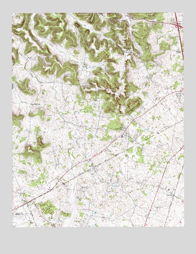
Rockfield, KY USGS Topographic Map
Click on map above to begin viewing in our Map Viewer.

This topographic map contains these locations and features:
Feature Name Type Latitude Longitude GNIS ID View Map
Barren River Volunteer Fire Department Station 1BuildingN36.9891°W86.5042°2637065View Map
Blue LevelPopulated PlaceN36.9775°W86.5411°487525View Map
Briggs HillSummitN36.9987°W86.5236°487908View Map
BrowningPopulated PlaceN36.9470°W86.6097°507592View Map
Browning Volunteer Fire DepartmentBuildingN36.9460°W86.6064°2637003View Map
Browning Volunteer Fire Department Station 2BuildingN36.9640°W86.5210°2637329View Map
Cedar BluffSummitN36.9916°W86.5914°2742797View Map
Cedar Grove ChurchChurchN36.9889°W86.6239°489202View Map
Grace Baptist ChurchChurchN36.9939°W86.5079°493065View Map
Millikens ChapelChurchN36.8784°W86.6117°498371View Map
PetrosPopulated PlaceN36.8973°W86.5967°508811View Map
Pleasant Hill CemeteryCemeteryN36.8970°W86.5753°500842View Map
Providence Knob Baptist Church Historical MarkerParkN36.9316°W86.5441°2744845View Map
Providence Knob ChurchChurchN36.9318°W86.5450°501382View Map
Rich PondPopulated PlaceN36.8942°W86.5094°501793View Map
Rich Pond Baptist ChurchChurchN36.8994°W86.5121°501794View Map
RockfieldPopulated PlaceN36.9103°W86.5644°502163View Map
Rockfield SchoolSchoolN36.9278°W86.5444°502164View Map
Whitestone Quarry Baptist ChurchChurchN36.9782°W86.5401°506682View Map

Note: Coordinates in the location and feature list above are referenced to NAD83 datum.


Copyright (C) 2008-2025 Ryan Niemi / Sunset Dynamics ... All Rights Reserved