TopoQuest Logo
Do you find TopoQuest useful?
Help keep TopoQuest running and adding new maps/features by donating!
Bitcoin:  19c7KJd3qBynnjoSw5npx9KScwjBe4ifkT
Litecoin:  LXs6TkuXGGXo1vDsWCkWVdjQX94eUKd6ui
Home View Maps Find Maps Find Places Resources & Links


Adair, Illinois Topographic Map

USGS Map Title: Adair, IL
USGS Map MRC: 40090D4
DRG (GeoTIFF) Download: o40090d4.tif


Neighboring USGS Topographic Map Quads:


  Bushnell West, IL  
40090E5
 

  Bushnell East, IL  
40090E4
 

  Blyton, IL  
40090E3
 

  Bardolph, IL  
40090D5
 

  Adair, IL  
40090D4
 

  Smithfield, IL  
40090D3
 

  Industry, IL  
40090C5
 

  Vermont, IL  
40090C4
 

  Ipava, IL  
40090C3


Map MRC Location:

N41°
W91°
N41°
W90°
H8 H7 H6 H5 H4 H3 H2 H1
G8 G7 G6 G5 G4 G3 G2 G1
F8 F7 F6 F5 F4 F3 F2 F1
E8 E7 E6 E5 E4 E3 E2 E1
D8 D7 D6 D5 D4 D3 D2 D1
C8 C7 C6 C5 C4 C3 C2 C1
B8 B7 B6 B5 B4 B3 B2 B1
A8 A7 A6 A5 A4 A3 A2 A1
N40°
W91°
N40°
W90°

Adair, IL USGS 1:24K Topographic Map Preview:
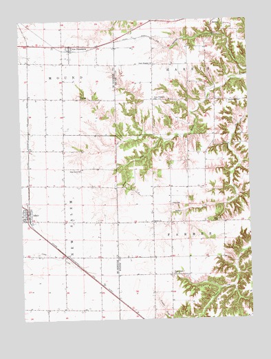
Adair, IL USGS Topographic Map
Click on map above to begin viewing in our Map Viewer.

This topographic map contains these locations and features:
Feature Name Type Latitude Longitude GNIS ID View Map
AdairPopulated PlaceN40.4189°W90.4968°403339View Map
Adair Census Designated PlaceCensusN40.4183°W90.4974°2628541View Map
Adair Community High School (historical)SchoolN40.4164°W90.4998°1824298View Map
Adair Post OfficePost OfficeN40.4181°W90.4971°2788528View Map
Adair United Brethren Church (historical)ChurchN40.4187°W90.4979°1824296View Map
Adair United Methodist Church (historical)ChurchN40.4167°W90.4973°1824297View Map
Barker CemeteryCemeteryN40.4153°W90.4287°1773310View Map
Barker ChurchChurchN40.4153°W90.4276°403900View Map
Buckwheat School (historical)SchoolN40.4659°W90.3790°405144View Map
Hazel Green School (historical)SchoolN40.3939°W90.4179°409985View Map
Hughes Centennial FarmLocaleN40.3862°W90.4287°1802224View Map
Ipava DamDamN40.3884°W90.3835°1692615View Map
Ipava Settling BasinReservoirN40.3884°W90.3835°1692616View Map
Leaman Station (historical)LocaleN40.4812°W90.3798°1802140View Map
Marietta CemeteryCemeteryN40.4992°W90.3943°1773347View Map
New PhiladelphiaPopulated PlaceN40.4895°W90.4723°414451View Map
New Philadelphia School (historical)SchoolN40.4898°W90.4668°1824433View Map
New Philadelphia United Methodist ChurchChurchN40.4895°W90.4712°1824434View Map
New Salem Fire Protection DistrictBuildingN40.4201°W90.4966°2640147View Map
Pilot Grove School (historical)SchoolN40.4378°W90.4673°415681View Map
Pilot Grove United Brethren Church (historical)ChurchN40.4381°W90.4762°1824443View Map
Point Pleasant CemeteryCemeteryN40.4817°W90.4254°1773357View Map
Point Pleasant School (historical)SchoolN40.4670°W90.4265°415979View Map
Point Pleasant United Methodist ChurchChurchN40.4817°W90.4265°415976View Map
Rich School (historical)SchoolN40.4675°W90.4662°416591View Map
Shinn School (historical)SchoolN40.4234°W90.4179°418429View Map
Shoo FlyPopulated PlaceN40.4162°W90.4768°1824470View Map
Temple CemeteryCemeteryN40.4164°W90.3926°419585View Map
Township of FarmersCivilN40.4069°W90.3914°428992View Map
Township of HarrisCivilN40.4998°W90.3918°429113View Map
Village of MariettaCivilN40.4994°W90.3930°2399255View Map

Note: Coordinates in the location and feature list above are referenced to NAD83 datum.


Copyright (C) 2008-2025 Ryan Niemi / Sunset Dynamics ... All Rights Reserved