TopoQuest Logo
Do you find TopoQuest useful?
Help keep TopoQuest running and adding new maps/features by donating!
Bitcoin:  19c7KJd3qBynnjoSw5npx9KScwjBe4ifkT
Litecoin:  LXs6TkuXGGXo1vDsWCkWVdjQX94eUKd6ui
Home View Maps Find Maps Find Places Resources & Links


Vermont, Illinois Topographic Map

USGS Map Title: Vermont, IL
USGS Map MRC: 40090C4
DRG (GeoTIFF) Download: o40090c4.tif


Neighboring USGS Topographic Map Quads:


  Bardolph, IL  
40090D5
 

  Adair, IL  
40090D4
 

  Smithfield, IL  
40090D3
 

  Industry, IL  
40090C5
 

  Vermont, IL  
40090C4
 

  Ipava, IL  
40090C3
 

  Rushville North, IL  
40090B5
 

  Ray, IL  
40090B4
 

  Astoria, IL  
40090B3


Map MRC Location:

N41°
W91°
N41°
W90°
H8 H7 H6 H5 H4 H3 H2 H1
G8 G7 G6 G5 G4 G3 G2 G1
F8 F7 F6 F5 F4 F3 F2 F1
E8 E7 E6 E5 E4 E3 E2 E1
D8 D7 D6 D5 D4 D3 D2 D1
C8 C7 C6 C5 C4 C3 C2 C1
B8 B7 B6 B5 B4 B3 B2 B1
A8 A7 A6 A5 A4 A3 A2 A1
N40°
W91°
N40°
W90°

Vermont, IL USGS 1:24K Topographic Map Preview:
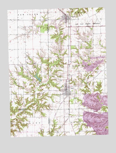
Vermont, IL USGS Topographic Map
Click on map above to begin viewing in our Map Viewer.

This topographic map contains these locations and features:
Feature Name Type Latitude Longitude GNIS ID View Map
Adams CemeteryCemeteryN40.2684°W90.4546°1984417View Map
Bailey CemeteryCemeteryN40.3386°W90.4290°1773308View Map
Bailey School (historical)SchoolN40.3387°W90.4287°1747950View Map
Beghtol CemeteryCemeteryN40.2564°W90.4612°404107View Map
Cox School (historical)SchoolN40.2906°W90.4062°406694View Map
Dennis CemeteryCemeteryN40.2923°W90.4798°1954733View Map
Diversion Drainage DamDamN40.3417°W90.4001°1692554View Map
Diversion Drainage LakeReservoirN40.3417°W90.4001°1692555View Map
Easley CemeteryCemeteryN40.3017°W90.3918°407592View Map
Farr School (historical)SchoolN40.2623°W90.3937°1747954View Map
Flatwoods School (historical)SchoolN40.2623°W90.4690°1720672View Map
Foster Point CemeteryCemeteryN40.3581°W90.4687°408568View Map
Foster Point School (historical)SchoolN40.3503°W90.4693°1721214View Map
France CemeteryCemeteryN40.2689°W90.4560°1720673View Map
Freshwater LakeReservoirN40.2631°W90.4036°1691212View Map
Freshwater Lake DamDamN40.2701°W90.3941°1691211View Map
Harris CemeteryCemeteryN40.3639°W90.4493°409843View Map
Harvey School (historical)SchoolN40.2917°W90.4646°409906View Map
Heller LakeReservoirN40.3524°W90.4139°1692561View Map
Heller Lake DamDamN40.3517°W90.4118°1692560View Map
Hickory Grove School (historical)SchoolN40.3489°W90.3907°1747956View Map
Kost School (historical)SchoolN40.2614°W90.4307°1747958View Map
Laurel Hill CemeteryCemeteryN40.3648°W90.4187°1773341View Map
Miles CemeteryCemeteryN40.3167°W90.4771°1954736View Map
Mud Acre School (historical)SchoolN40.3217°W90.4690°414162View Map
Phillips CemeteryCemeteryN40.2642°W90.4996°415611View Map
Richmond AirportAirportN40.3447°W90.4430°2679092View Map
Sugar Creek Cumberland Prestyterian Church (historical)ChurchN40.3509°W90.4785°1824480View Map
Table GrovePopulated PlaceN40.3642°W90.4251°419515View Map
Table Grove Community ChurchChurchN40.3664°W90.4254°1802183View Map
Table Grove Fire Protection DistrictBuildingN40.3618°W90.4250°2640513View Map
Table Grove Post OfficePost OfficeN40.3657°W90.4247°2788574View Map
Table Grove School (historical)SchoolN40.3670°W90.4307°1802125View Map
Table Grove Village SquareParkN40.3659°W90.4251°1802124View Map
Township of VermontCivilN40.3199°W90.3918°429867View Map
Union Center School (historical)SchoolN40.3195°W90.3918°1747964View Map
Union Chapel CemeteryCemeteryN40.3359°W90.3929°1984293View Map
V I T Junior-Senior High SchoolSchoolN40.3575°W90.4190°1802184View Map
VermontPopulated PlaceN40.2942°W90.4279°420265View Map
Vermont CemeteryCemeteryN40.3028°W90.4251°1773372View Map
Vermont Fire Protection DistrictBuildingN40.2931°W90.4281°2640272View Map
Vermont New LakeReservoirN40.3076°W90.4632°1691272View Map
Vermont New Lake DamDamN40.3050°W90.4618°1691271View Map
Vermont Post OfficePost OfficeN40.2965°W90.4287°2788839View Map
Vermont School (historical)SchoolN40.2984°W90.4282°1802126View Map
Village of Table GroveCivilN40.3650°W90.4252°2399946View Map
Village of VermontCivilN40.2957°W90.4290°2400059View Map
Wolfden BranchStreamN40.2942°W90.4668°421399View Map

Note: Coordinates in the location and feature list above are referenced to NAD83 datum.


Copyright (C) 2008-2025 Ryan Niemi / Sunset Dynamics ... All Rights Reserved