TopoQuest Logo
Do you find TopoQuest useful?
Help keep TopoQuest running and adding new maps/features by donating!
Bitcoin:  19c7KJd3qBynnjoSw5npx9KScwjBe4ifkT
Litecoin:  LXs6TkuXGGXo1vDsWCkWVdjQX94eUKd6ui
Home View Maps Find Maps Find Places Resources & Links


Dundee, Oregon Topographic Map

USGS Map Title: Dundee, OR
USGS Map MRC: 45123C1
DRG (GeoTIFF) Download: o45123c1.tif


Neighboring USGS Topographic Map Quads:


  Gaston, OR  
45123D2
 

  Laurelwood, OR  
45123D1
 

  Scholls, OR  
45122D8
 

  Carlton, OR  
45123C2
 

  Dundee, OR  
45123C1
 

  Newberg, OR  
45122C8
 

  McMinnville, OR  
45123B2
 

  Dayton, OR  
45123B1
 

  Saint Paul, OR  
45122B8


Map MRC Location:

N46°
W124°
N46°
W123°
H8 H7 H6 H5 H4 H3 H2 H1
G8 G7 G6 G5 G4 G3 G2 G1
F8 F7 F6 F5 F4 F3 F2 F1
E8 E7 E6 E5 E4 E3 E2 E1
D8 D7 D6 D5 D4 D3 D2 D1
C8 C7 C6 C5 C4 C3 C2 C1
B8 B7 B6 B5 B4 B3 B2 B1
A8 A7 A6 A5 A4 A3 A2 A1
N45°
W124°
N45°
W123°

Dundee, OR USGS 1:24K Topographic Map Preview:
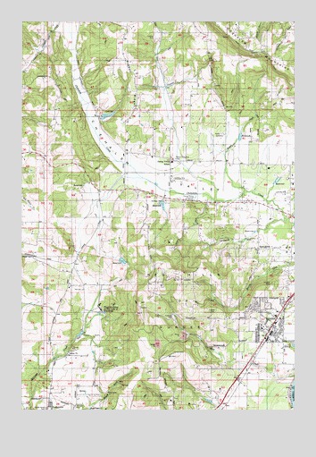
Dundee, OR USGS Topographic Map
Click on map above to begin viewing in our Map Viewer.

This topographic map contains these locations and features:
Feature Name Type Latitude Longitude GNIS ID View Map
Big SpringSpringN45.2721°W123.0707°1160887View Map
Billick/Dundee School ParkParkN45.2815°W123.0118°1157904View Map
Bronson CreekStreamN45.3110°W123.0054°1130204View Map
Bryan CreekStreamN45.3201°W123.0232°1157956View Map
Chehalem AirparkAirportN45.3238°W123.0555°1131400View Map
City of DundeeCivilN45.2759°W123.0072°2410370View Map
Crabtree ParkParkN45.2798°W123.0568°1157903View Map
Diamond Post Office (historical)Post OfficeN45.2762°W123.0887°1164316View Map
DundeePopulated PlaceN45.2782°W123.0109°1166649View Map
Dundee City HallBuildingN45.2821°W123.0138°2661111View Map
Dundee Elementary SchoolSchoolN45.2803°W123.0100°2496446View Map
Dundee Fire DepartmentBuildingN45.2772°W123.0111°2576552View Map
Dundee Municipal CourthouseBuildingN45.2821°W123.0138°2661112View Map
Dundee Pioneer CemeteryCemeteryN45.2840°W123.0213°1130205View Map
Dundee Police DepartmentBuildingN45.2821°W123.0138°2737667View Map
Dundee Post OfficePost OfficeN45.2782°W123.0109°1165186View Map
Dundee Publlic WorksBuildingN45.2821°W123.0138°2661486View Map
Dundee Scenic OverlookParkN45.2793°W123.0220°2058176View Map
E R Baker DamDamN45.3465°W123.0895°1133512View Map
E R Baker ReservoirReservoirN45.3446°W123.0875°1162627View Map
Ewing Young Elementary SchoolSchoolN45.3297°W123.0575°1120547View Map
Ewing Young Historical MarkerParkN45.3173°W123.0473°1163708View Map
Falcon Crest ParkParkN45.2762°W123.0207°2058177View Map
Hess CreekStreamN45.2610°W123.0007°1121779View Map
Hickory Hill Farm DamDamN45.3165°W123.0629°1131580View Map
Hickory Hill Farm ReservoirReservoirN45.3160°W123.0618°1158846View Map
Kuehne DamDamN45.2982°W123.0795°1131582View Map
Kuehne ReservoirReservoirN45.2979°W123.0800°1158847View Map
Lafayette Pioneer CemeteryCemeteryN45.2512°W123.1012°1158080View Map
Lafayette SpringSpringN45.2587°W123.0804°1160888View Map
Nelson SpringSpringN45.2571°W123.0804°1160889View Map
Newberg DivisionCivilN45.3145°W123.0073°1938073View Map
Noble CemeteryCemeteryN45.3390°W123.0348°1124698View Map
Pringle SpringSpringN45.2637°W123.0707°1130202View Map
Red Hills of DundeeRangeN45.2857°W123.0520°1158024View Map
Ribbon RidgeRidgeN45.3543°W123.0740°1125970View Map
Ribbon Ridge AirportAirportN45.3685°W123.0654°2645964View Map
Ribbon Ridge School (historical)SchoolN45.3515°W123.0737°1158025View Map
Saint Josephs DamDamN45.2804°W123.0868°1160890View Map
Saint Josephs ReservoirReservoirN45.2799°W123.0867°1160891View Map
Stan Jost AirportAirportN45.3251°W123.0185°2645963View Map
SunnycrestPopulated PlaceN45.3018°W123.0179°1127731View Map
Tangen ReservoirReservoirN45.3234°W123.0094°1130674View Map
Trappist Abbey of Our Lady of GuadalupeChurchN45.2823°W123.0902°1128209View Map
Valley View School (historical)SchoolN45.3207°W123.0790°1158047View Map
Walker DamDamN45.3365°W123.0262°1131529View Map
Walker ReservoirReservoirN45.3379°W123.0263°1158844View Map
West Chehalem (historical)LocaleN45.3332°W123.0790°1158081View Map
West Chehalem Post Office (historical)Post OfficeN45.3332°W123.0790°1166148View Map
Zink ReservoirReservoirN45.2684°W123.0933°1130203View Map

Note: Coordinates in the location and feature list above are referenced to NAD83 datum.


Copyright (C) 2008-2024 Ryan Niemi / Sunset Dynamics ... All Rights Reserved