TopoQuest Logo
Do you find TopoQuest useful?
Help keep TopoQuest running and adding new maps/features by donating!
Bitcoin:  19c7KJd3qBynnjoSw5npx9KScwjBe4ifkT
Litecoin:  LXs6TkuXGGXo1vDsWCkWVdjQX94eUKd6ui
Home View Maps Find Maps Find Places Resources & Links


Gaston, Oregon Topographic Map

USGS Map Title: Gaston, OR
USGS Map MRC: 45123D2
DRG (GeoTIFF) Download: o45123d2.tif


Neighboring USGS Topographic Map Quads:


  Roaring Creek, OR  
45123E3
 

  Gales Creek, OR  
45123E2
 

  Forest Grove, OR  
45123E1
 

  Turner Creek, OR  
45123D3
 

  Gaston, OR  
45123D2
 

  Laurelwood, OR  
45123D1
 

  Fairdale, OR  
45123C3
 

  Carlton, OR  
45123C2
 

  Dundee, OR  
45123C1


Map MRC Location:

N46°
W124°
N46°
W123°
H8 H7 H6 H5 H4 H3 H2 H1
G8 G7 G6 G5 G4 G3 G2 G1
F8 F7 F6 F5 F4 F3 F2 F1
E8 E7 E6 E5 E4 E3 E2 E1
D8 D7 D6 D5 D4 D3 D2 D1
C8 C7 C6 C5 C4 C3 C2 C1
B8 B7 B6 B5 B4 B3 B2 B1
A8 A7 A6 A5 A4 A3 A2 A1
N45°
W124°
N45°
W123°

Gaston, OR USGS 1:24K Topographic Map Preview:
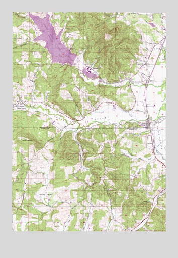
Gaston, OR USGS Topographic Map
Click on map above to begin viewing in our Map Viewer.

This topographic map contains these locations and features:
Feature Name Type Latitude Longitude GNIS ID View Map
Black Jack CreekStreamN45.4387°W123.1498°1163405View Map
Bodeen DamDamN45.4065°W123.2162°1131507View Map
Bodeen LakeReservoirN45.4093°W123.2105°1131506View Map
Cherry GrovePopulated PlaceN45.4476°W123.2434°1162897View Map
Cherry Grove CemeteryCemeteryN45.4498°W123.2359°1163404View Map
Cherry Grove Post Office (historical)Post OfficeN45.4476°W123.2434°1165042View Map
City of GastonCivilN45.4357°W123.1437°2410575View Map
Cove OrchardPopulated PlaceN45.3751°W123.1548°1162920View Map
Cove Orchard Post Office (historical)Post OfficeN45.3751°W123.1548°1165096View Map
Dellwood (historical)LocaleN45.4254°W123.1368°1162937View Map
Dick Fisher AirportAirportN45.4118°W123.1362°2645966View Map
Dilley Elementary SchoolSchoolN45.4903°W123.1275°2474962View Map
Dorin BranchStreamN45.4832°W123.2359°1130082View Map
Earnest ReservoirReservoirN45.4026°W123.1853°1130083View Map
Elk Cove VineyardsLocaleN45.4158°W123.1850°2664104View Map
Forest Dale School (historical)SchoolN45.4834°W123.2132°1157983View Map
Garrish ValleyBasinN45.3946°W123.2248°1163002View Map
GastonPopulated PlaceN45.4362°W123.1396°1157988View Map
Gaston City HallBuildingN45.4378°W123.1403°2661160View Map
Gaston Elementary SchoolSchoolN45.4344°W123.1425°1638629View Map
Gaston Junior and Senior High SchoolSchoolN45.4356°W123.1439°1638630View Map
Gaston Municipal CourtBuildingN45.4378°W123.1403°2661231View Map
Gaston Police DepartmentBuildingN45.4378°W123.1404°2737785View Map
Gaston Post OfficePost OfficeN45.4362°W123.1396°1165296View Map
Gaston Rural Fire Protection DistrictBuildingN45.4369°W123.1386°2576650View Map
Goodin CreekStreamN45.4221°W123.1348°1163015View Map
Goodin Creek AirportAirportN45.4109°W123.1490°2645965View Map
Graham DamDamN45.4915°W123.1362°1163603View Map
Graham ReservoirReservoirN45.4930°W123.1379°1158839View Map
Grand Cru EstatesLocaleN45.4200°W123.1525°2664106View Map
Havens ReservoirReservoirN45.4808°W123.1354°1162673View Map
Hawks Mountain RanchLocaleN45.4575°W123.2103°2664097View Map
Henry Hagg County ParkParkN45.4850°W123.2088°2040241View Map
Henry Hagg LakeReservoirN45.4833°W123.2183°1158095View Map
Henry Hagg Lake County Park Ramp ALocaleN45.4825°W123.2111°2668317View Map
Henry Hagg Lake County Park Ramp CLocaleN45.4888°W123.2281°2668172View Map
Hering CreekStreamN45.4465°W123.2296°1163042View Map
Hill CreekStreamN45.4401°W123.1254°1157995View Map
Kramer VineyardsLocaleN45.4100°W123.1706°2664105View Map
Library of GastonBuildingN45.4378°W123.1403°2661161View Map
Little Russell CreekStreamN45.4165°W123.1404°1123269View Map
Mercer CreekStreamN45.4337°W123.1982°1158013View Map
Mount Olive Lutheran CemeteryCemeteryN45.4734°W123.1400°1162672View Map
Mount RichmondSummitN45.4280°W123.2412°1158026View Map
Mulholland FarmsLocaleN45.4372°W123.2175°2664098View Map
Muskrat PondLakeN45.4622°W123.1636°1163403View Map
O'Neil CreekStreamN45.4729°W123.1262°1158018View Map
PattonPopulated PlaceN45.4471°W123.1423°1163196View Map
Patton ValleyValleyN45.4493°W123.1346°1163197View Map
Phillips ReservoirReservoirN45.4215°W123.2232°1130084View Map
Roberts School (historical)LocaleN45.4715°W123.2373°1158027View Map
Sain CreekStreamN45.4826°W123.2423°1163239View Map
Scoggins CreekStreamN45.4601°W123.1259°1158033View Map
Scoggins Creek Picnic Area (historical)LocaleN45.4993°W123.2473°1157920View Map
Scoggins DamDamN45.4734°W123.2040°1163401View Map
Scoggins SloughStreamN45.4584°W123.1451°1163261View Map
Scoggins ValleyValleyN45.4609°W123.1568°1160880View Map
SeghersLocaleN45.4604°W123.1354°1166709View Map
Seghers Post Office (historical)Post OfficeN45.4604°W123.1354°1165926View Map
Seth School (historical)SchoolN45.4432°W123.1882°1161503View Map
Stimson Lumber Company Wastewater Treatment FacilityLocaleN45.4637°W123.1840°2660703View Map
Stimson MillLocaleN45.4684°W123.1884°1163292View Map
Stimson MillpondReservoirN45.4648°W123.1896°1163402View Map
Teffer (historical)LocaleN45.4779°W123.1304°1166580View Map
Upstream RanchLocaleN45.4364°W123.1839°2664099View Map
Valley Baptist ChurchChurchN45.4478°W123.2467°2508964View Map
Wapato Lake National Wildlife RefugeParkN45.4222°W123.1256°2765549View Map
Wapato Valley ChurchChurchN45.4367°W123.1400°2508963View Map
Wapatoo Post Office (historical)Post OfficeN45.4226°W123.1362°1164768View Map
Western Division Service Center Airport (historical)AirportN45.4540°W123.1554°1163584View Map
Williams CanyonValleyN45.4315°W123.1987°1163357View Map

Note: Coordinates in the location and feature list above are referenced to NAD83 datum.


Copyright (C) 2008-2024 Ryan Niemi / Sunset Dynamics ... All Rights Reserved