TopoQuest Logo
Do you find TopoQuest useful?
Help keep TopoQuest running and adding new maps/features by donating!
Bitcoin:  19c7KJd3qBynnjoSw5npx9KScwjBe4ifkT
Litecoin:  LXs6TkuXGGXo1vDsWCkWVdjQX94eUKd6ui
Home View Maps Find Maps Find Places Resources & Links


Dustin, Oklahoma Topographic Map

USGS Map Title: Dustin, OK
USGS Map MRC: 35096C1
DRG (GeoTIFF) Download: o35096c1.tif


Neighboring USGS Topographic Map Quads:


  Clearview, OK  
35096D2
 

  Pharoah, OK  
35096D1
 

  Henryetta, OK  
35095D8
 

  Weleetka, OK  
35096C2
 

  Dustin, OK  
35096C1
 

  Henryetta SW, OK  
35095C8
 

  Wetumka, OK  
35096B2
 

  Carson, OK  
35096B1
 

  Hanna, OK  
35095B8


Map MRC Location:

N36°
W97°
N36°
W96°
H8 H7 H6 H5 H4 H3 H2 H1
G8 G7 G6 G5 G4 G3 G2 G1
F8 F7 F6 F5 F4 F3 F2 F1
E8 E7 E6 E5 E4 E3 E2 E1
D8 D7 D6 D5 D4 D3 D2 D1
C8 C7 C6 C5 C4 C3 C2 C1
B8 B7 B6 B5 B4 B3 B2 B1
A8 A7 A6 A5 A4 A3 A2 A1
N35°
W97°
N35°
W96°

Dustin, OK USGS 1:24K Topographic Map Preview:
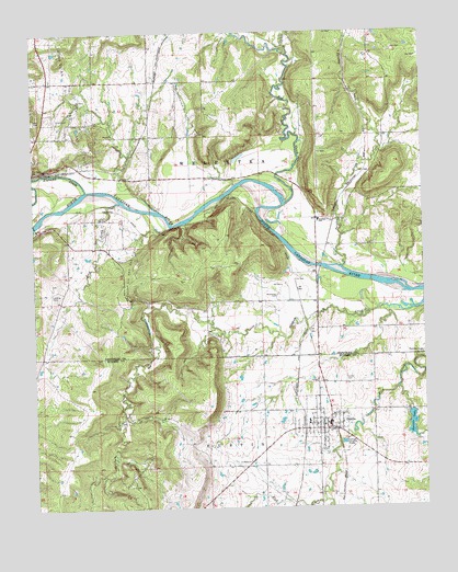
Dustin, OK USGS Topographic Map
Click on map above to begin viewing in our Map Viewer.

This topographic map contains these locations and features:
Feature Name Type Latitude Longitude GNIS ID View Map
Alabama CreekStreamN35.3337°W96.1083°1089561View Map
Bad CreekStreamN35.3295°W96.0444°1089781View Map
BookerteePopulated PlaceN35.3673°W96.0833°1763715View Map
DustinPopulated PlaceN35.2707°W96.0308°1092315View Map
Dustin CemeteryCemeteryN35.2835°W96.0246°1092316View Map
Dustin Elementary SchoolSchoolN35.2726°W96.0378°1790632View Map
Dustin Fire DepartmentBuildingN35.2703°W96.0318°2657256View Map
Dustin High SchoolSchoolN35.2721°W96.0378°1803963View Map
Dustin LakeReservoirN35.2719°W96.0045°1092317View Map
Dustin Lake DamDamN35.2668°W96.0036°1751358View Map
East Weleetka Oil and Gas FieldOilfieldN35.3562°W96.0747°1092451View Map
Fife CemeteryCemeteryN35.2880°W96.0056°2724224View Map
Gregory Oil and Gas FieldOilfieldN35.3126°W96.0936°1093412View Map
KVAZ-FM (Henryetta)TowerN35.3657°W96.0097°1102801View Map
Mosewiley CemeteryCemeteryN35.3061°W96.0471°1095539View Map
Oknoname 063012 DamDamN35.2668°W96.0136°1752943View Map
Oknoname 063012 ReservoirReservoirN35.2668°W96.0136°1752944View Map
Oknoname 107030 DamDamN35.3501°W96.1103°1753411View Map
Oknoname 107030 ReservoirReservoirN35.3501°W96.1103°1753412View Map
Old Dustin CemeteryCemeteryN35.2835°W96.0361°2095475View Map
Parsley CreekStreamN35.3129°W96.0269°1096455View Map
Rock CreekStreamN35.3307°W96.0972°1097288View Map
Salt CreekStreamN35.3690°W96.0428°1097694View Map
Thewatle ChurchChurchN35.2904°W96.0014°1098843View Map
Town of DustinCivilN35.2712°W96.0320°2412452View Map
Township of WeleetkaCivilN35.3418°W96.0697°1824903View Map
West Dustin Oil FieldOilfieldN35.2593°W96.0914°1099541View Map

Note: Coordinates in the location and feature list above are referenced to NAD83 datum.


Copyright (C) 2008-2024 Ryan Niemi / Sunset Dynamics ... All Rights Reserved