TopoQuest Logo
Do you find TopoQuest useful?
Help keep TopoQuest running and adding new maps/features by donating!
Bitcoin:  19c7KJd3qBynnjoSw5npx9KScwjBe4ifkT
Litecoin:  LXs6TkuXGGXo1vDsWCkWVdjQX94eUKd6ui
Home View Maps Find Maps Find Places Resources & Links


Weleetka, Oklahoma Topographic Map

USGS Map Title: Weleetka, OK
USGS Map MRC: 35096C2
DRG (GeoTIFF) Download: o35096c2.tif


Neighboring USGS Topographic Map Quads:


  Okemah, OK  
35096D3
 

  Clearview, OK  
35096D2
 

  Pharoah, OK  
35096D1
 

  Okemah SE, OK  
35096C3
 

  Weleetka, OK  
35096C2
 

  Dustin, OK  
35096C1
 

  Yeager, OK  
35096B3
 

  Wetumka, OK  
35096B2
 

  Carson, OK  
35096B1


Map MRC Location:

N36°
W97°
N36°
W96°
H8 H7 H6 H5 H4 H3 H2 H1
G8 G7 G6 G5 G4 G3 G2 G1
F8 F7 F6 F5 F4 F3 F2 F1
E8 E7 E6 E5 E4 E3 E2 E1
D8 D7 D6 D5 D4 D3 D2 D1
C8 C7 C6 C5 C4 C3 C2 C1
B8 B7 B6 B5 B4 B3 B2 B1
A8 A7 A6 A5 A4 A3 A2 A1
N35°
W97°
N35°
W96°

Weleetka, OK USGS 1:24K Topographic Map Preview:
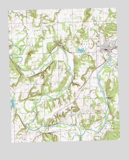
Weleetka, OK USGS Topographic Map
Click on map above to begin viewing in our Map Viewer.

This topographic map contains these locations and features:
Feature Name Type Latitude Longitude GNIS ID View Map
Alabama ChurchChurchN35.3484°W96.1458°1089560View Map
Crestwood CemeteryCemeteryN35.3404°W96.1253°1091820View Map
East Wetumka Oil and Gas FieldOilfieldN35.2568°W96.1825°1092452View Map
Fairlawn CemeteryCemeteryN35.3489°W96.1411°2710143View Map
First Christian ChurchChurchN35.3379°W96.1386°1790125View Map
Flat Rock CreekStreamN35.3418°W96.2422°1092881View Map
Graham Elementary SchoolSchoolN35.3347°W96.1371°1093294View Map
Graham High SchoolSchoolN35.3347°W96.1371°2712864View Map
Lake Wetumka DamDamN35.2851°W96.2470°1751356View Map
North Fork CemeteryCemeteryN35.3623°W96.2103°1095944View Map
North Fork ChurchChurchN35.3551°W96.2106°1095945View Map
Salt Creek CemeteryCemeteryN35.2812°W96.2447°1097697View Map
Salt Creek ChurchChurchN35.2865°W96.2464°1097701View Map
Sand Creek CemeteryCemeteryN35.2522°W96.1490°2711587View Map
Sand Creek ChurchChurchN35.2540°W96.1506°1097776View Map
South Alabama Oil and Gas FieldOilfieldN35.2612°W96.1400°1098205View Map
Southwest Alabama Oil FieldOilfieldN35.2756°W96.1622°1098312View Map
Spence Memorial Elementary SchoolSchoolN35.3402°W96.1343°1790689View Map
Town of WeleetkaCivilN35.3418°W96.1355°2413463View Map
Township of Hickory RidgeCivilN35.3418°W96.2420°1824902View Map
WeleetkaPopulated PlaceN35.3356°W96.1364°1099475View Map
Weleetka DamDamN35.3351°W96.1636°1751316View Map
Weleetka DivisionCivilN35.3576°W96.1265°1937910View Map
Weleetka Graham Emergency Medical ServicesBuildingN35.3353°W96.1378°2695883View Map
Weleetka High SchoolSchoolN35.3392°W96.1346°1790512View Map
Weleetka Junior High SchoolSchoolN35.3391°W96.1348°2713041View Map
Weleetka LakeReservoirN35.3359°W96.1675°1099476View Map
Weleetka Oil FieldOilfieldN35.3440°W96.1411°1099477View Map
Weleetka Police DepartmentBuildingN35.3359°W96.1366°2757425View Map
Weleetka Post OfficePost OfficeN35.3358°W96.1399°1819096View Map
Weleetka Volunteer Fire DepartmentBuildingN35.3353°W96.1375°2656919View Map
West Alabama Oil FieldOilfieldN35.3129°W96.1742°1099497View Map
West Weleetka Oil FieldOilfieldN35.3409°W96.1886°1099621View Map
Wewoka CreekStreamN35.2551°W96.1694°1099659View Map

Note: Coordinates in the location and feature list above are referenced to NAD83 datum.


Copyright (C) 2008-2024 Ryan Niemi / Sunset Dynamics ... All Rights Reserved