TopoQuest Logo
Do you find TopoQuest useful?
Help keep TopoQuest running and adding new maps/features by donating!
Bitcoin:  19c7KJd3qBynnjoSw5npx9KScwjBe4ifkT
Litecoin:  LXs6TkuXGGXo1vDsWCkWVdjQX94eUKd6ui
Home View Maps Find Maps Find Places Resources & Links


Dutton, Alabama Topographic Map

USGS Map Title: Dutton, AL
USGS Map MRC: 34085E8
DRG (GeoTIFF) Download: o34085e8.tif


Neighboring USGS Topographic Map Quads:


  Scottsboro, AL  
34086F1
 

  Hollywood, AL  
34085F8
 

  Henagar, AL  
34085F7
 

  Langston, AL  
34086E1
 

  Dutton, AL  
34085E8
 

  Sylvania, AL  
34085E7
 

  Grove Oak, AL  
34086D1
 

  Fyffe, AL  
34085D8
 

  Chavies, AL  
34085D7


Map MRC Location:

N35°
W86°
N35°
W85°
H8 H7 H6 H5 H4 H3 H2 H1
G8 G7 G6 G5 G4 G3 G2 G1
F8 F7 F6 F5 F4 F3 F2 F1
E8 E7 E6 E5 E4 E3 E2 E1
D8 D7 D6 D5 D4 D3 D2 D1
C8 C7 C6 C5 C4 C3 C2 C1
B8 B7 B6 B5 B4 B3 B2 B1
A8 A7 A6 A5 A4 A3 A2 A1
N34°
W86°
N34°
W85°

Dutton, AL USGS 1:24K Topographic Map Preview:
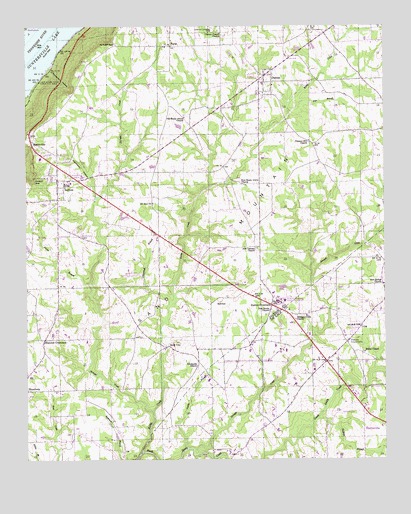
Dutton, AL USGS Topographic Map
Click on map above to begin viewing in our Map Viewer.

This topographic map contains these locations and features:
Feature Name Type Latitude Longitude GNIS ID View Map
Bailey ChapelChurchN34.5309°W85.8825°150079View Map
BellviewPopulated PlaceN34.5451°W85.9336°156049View Map
Bellview School (historical)SchoolN34.5454°W85.9369°139098View Map
Bethany ChurchChurchN34.5601°W85.9994°149554View Map
Bluff CemeteryCemeteryN34.5823°W85.9933°114605View Map
Callahan School (historical)SchoolN34.5834°W85.8836°139120View Map
Carter BranchStreamN34.5509°W85.9778°115658View Map
Carter Chapel (historical)ChurchN34.6015°W85.9366°1700326View Map
Chaney Chapel CemeteryCemeteryN34.6234°W85.9341°115945View Map
Chaney Chapel ChurchChurchN34.6229°W85.9308°115946View Map
Chisenhall BarBarN34.6237°W85.9930°139134View Map
Chisenhall BranchStreamN34.5451°W85.9491°116062View Map
Dawson School (historical)SchoolN34.5609°W85.9208°1959037View Map
Duncan CrossroadsPopulated PlaceN34.5445°W85.9144°117663View Map
DuttonPopulated PlaceN34.6109°W85.9169°117699View Map
Dutton Post OfficePost OfficeN34.6115°W85.9143°2789058View Map
Dutton Volunteer Fire DepartmentBuildingN34.6091°W85.9173°2682649View Map
Ferncliff (historical)Populated PlaceN34.6195°W85.9680°139163View Map
Ferncliff GapGapN34.6198°W85.9689°118261View Map
Flat BranchStreamN34.6004°W85.9080°118362View Map
Flowers Saw Mill (historical)LocaleN34.5706°W85.9533°1959040View Map
Goodman HollowValleyN34.6129°W85.9919°119145View Map
Gossett GapGapN34.5806°W85.9966°119189View Map
Hancock ChurchChurchN34.5343°W85.9936°149571View Map
Hancock CrossroadsPopulated PlaceN34.5348°W85.9936°119669View Map
Hannah (historical)Populated PlaceN34.5329°W85.9428°139183View Map
Happy Hill Church (historical)ChurchN34.5323°W85.8980°1700294View Map
HodgePopulated PlaceN34.6195°W85.9494°156486View Map
Hodge ChurchChurchN34.6209°W85.9489°149573View Map
Jackie BranchStreamN34.5034°W85.9439°150304View Map
Kirby CreekStreamN34.5023°W85.9597°154466View Map
Lake Shore Drive Cabin Site AreaLocaleN34.6090°W85.9953°121324View Map
Macedonia Volunteer Fire DepartmentBuildingN34.5241°W85.9997°2683482View Map
Mount Zion ChurchChurchN34.5740°W85.9558°123493View Map
New Bethel ChurchChurchN34.5506°W85.8755°150418View Map
New Canaan ChurchChurchN34.5609°W85.9191°123733View Map
New Sardis ChurchChurchN34.5434°W85.9144°152677View Map
New Shady Grove ChurchChurchN34.5793°W85.9233°152679View Map
Northeast Alabama State Junior CollegeSchoolN34.5459°W85.9097°139236View Map
Old Brown Mill (historical)LocaleN34.5795°W85.9305°1959057View Map
Old Sardis CemeteryCemeteryN34.5259°W85.9408°1805524View Map
Old Sardis ChurchChurchN34.5273°W85.9403°152793View Map
Old Shady Grove ChurchChurchN34.5987°W85.9447°152794View Map
Patterson School (historical)SchoolN34.5387°W85.9619°139246View Map
Phillips BranchStreamN34.5120°W85.8983°150453View Map
Pleasant Hill ChurchChurchN34.5920°W85.9008°125014View Map
Powell Volunteer Fire DepartmentBuildingN34.5303°W85.8930°2682939View Map
Powells CrossroadsPopulated PlaceN34.5340°W85.8886°156925View Map
Rock CityPopulated PlaceN34.5326°W85.9503°125747View Map
Sand Mountain ChurchChurchN34.6018°W85.9758°149595View Map
SectionPopulated PlaceN34.5790°W85.9866°153363View Map
Section DivisionCivilN34.5688°W85.9705°165811View Map
Section GapGapN34.5918°W85.9975°126524View Map
Section High SchoolSchoolN34.5815°W85.9805°139284View Map
Section Police DepartmentBuildingN34.5812°W85.9877°2751776View Map
Section Post OfficePost OfficeN34.5812°W85.9881°2788934View Map
Section United Methodist ChurchChurchN34.5784°W85.9864°139285View Map
Section Volunteer Fire DepartmentBuildingN34.5806°W85.9884°2682672View Map
Straight CreekStreamN34.5018°W85.9397°150537View Map
Straight Creek ChurchChurchN34.5404°W85.9061°150538View Map
Straight Creek Church (historical)ChurchN34.5409°W85.8919°1700306View Map
Stringer CreekStreamN34.5140°W85.9558°127469View Map
Stringers Mill (historical)LocaleN34.5754°W85.9750°1959070View Map
Talley (historical)Populated PlaceN34.5195°W85.9814°139299View Map
Tomlin School (historical)SchoolN34.5215°W85.9339°1700307View Map
Town of DuttonCivilN34.6062°W85.9119°2406408View Map
Town of PowellCivilN34.5325°W85.8979°2407153View Map
Town of SectionCivilN34.5816°W85.9849°2407306View Map
Weatherley BranchStreamN34.5756°W85.9755°139309View Map
Weatherley HollowValleyN34.5765°W85.9753°128659View Map
White Mill (historical)LocaleN34.6101°W85.8980°1959074View Map
WKEA-FM (Scottsboro)TowerN34.5895°W85.9919°161219View Map

Note: Coordinates in the location and feature list above are referenced to NAD83 datum.


Copyright (C) 2008-2024 Ryan Niemi / Sunset Dynamics ... All Rights Reserved