TopoQuest Logo
Do you find TopoQuest useful?
Help keep TopoQuest running and adding new maps/features by donating!
Bitcoin:  19c7KJd3qBynnjoSw5npx9KScwjBe4ifkT
Litecoin:  LXs6TkuXGGXo1vDsWCkWVdjQX94eUKd6ui
Home View Maps Find Maps Find Places Resources & Links


Hollywood, Alabama Topographic Map

USGS Map Title: Hollywood, AL
USGS Map MRC: 34085F8
DRG (GeoTIFF) Download: o34085f8.tif


Neighboring USGS Topographic Map Quads:


  Mud Creek, AL  
34086G1
 

  Wannville, AL  
34085G8
 

  Stevenson, AL  
34085G7
 

  Scottsboro, AL  
34086F1
 

  Hollywood, AL  
34085F8
 

  Henagar, AL  
34085F7
 

  Langston, AL  
34086E1
 

  Dutton, AL  
34085E8
 

  Sylvania, AL  
34085E7


Map MRC Location:

N35°
W86°
N35°
W85°
H8 H7 H6 H5 H4 H3 H2 H1
G8 G7 G6 G5 G4 G3 G2 G1
F8 F7 F6 F5 F4 F3 F2 F1
E8 E7 E6 E5 E4 E3 E2 E1
D8 D7 D6 D5 D4 D3 D2 D1
C8 C7 C6 C5 C4 C3 C2 C1
B8 B7 B6 B5 B4 B3 B2 B1
A8 A7 A6 A5 A4 A3 A2 A1
N34°
W86°
N34°
W85°

Hollywood, AL USGS 1:24K Topographic Map Preview:
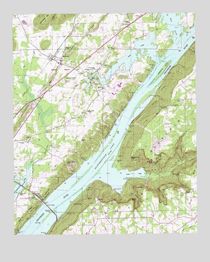
Hollywood, AL USGS Topographic Map
Click on map above to begin viewing in our Map Viewer.

This topographic map contains these locations and features:
Feature Name Type Latitude Longitude GNIS ID View Map
Backbone RidgeRidgeN34.7417°W85.9450°113332View Map
BellefontePopulated PlaceN34.7112°W85.9453°113878View Map
Bellefonte BarBarN34.6912°W85.9236°139094View Map
Bellefonte CemeteryCemeteryN34.7126°W85.9472°113879View Map
Bellefonte Depot (historical)LocaleN34.7423°W85.9569°139095View Map
Bellefonte IslandIslandN34.7190°W85.8969°113880View Map
Bellefonte Landing (historical)LocaleN34.6959°W85.9233°139096View Map
Bellefonte Nuclear PlantLocaleN34.7092°W85.9278°139097View Map
Bethany ChurchChurchN34.6740°W85.9703°114001View Map
Bethany School (historical)SchoolN34.6748°W85.9700°139100View Map
Bird Hill Church (historical)ChurchN34.6854°W85.9708°139103View Map
Bishop HollowValleyN34.7292°W85.8803°114383View Map
Camp JacksonLocaleN34.6495°W85.9328°151714View Map
Camp ScottsboroLocaleN34.6656°W85.9825°139124View Map
Cedar Glade Baptist ChurchChurchN34.6945°W85.9503°115773View Map
Chisenhall CemeteryCemeteryN34.6373°W85.9650°116064View Map
Clarks Lake (historical)ReservoirN34.6565°W85.9916°139138View Map
Comer BridgeBridgeN34.6406°W85.9769°116467View Map
Finnell CemeteryCemeteryN34.7156°W85.9164°118294View Map
Gant CemeteryCemeteryN34.6720°W85.9608°118810View Map
GeorgetownPopulated PlaceN34.6981°W85.8922°156400View Map
Gray (historical)Populated PlaceN34.6598°W85.8986°139172View Map
Green CemeteryCemeteryN34.6348°W85.9983°119334View Map
Hale GapGapN34.6445°W85.9430°119555View Map
Hales Ferry (historical)CrossingN34.6606°W85.9575°139180View Map
Hales Ferry GapGapN34.6651°W85.9636°119564View Map
Hansbrough CemeteryCemeteryN34.7187°W85.9453°119690View Map
Harlin Morgan and Rilie ReservationsParkN34.7165°W85.9541°119740View Map
Henry CemeteryCemeteryN34.6615°W85.9953°119974View Map
HollywoodPopulated PlaceN34.7242°W85.9725°120286View Map
Hollywood Junior High SchoolSchoolN34.7304°W85.9647°165450View Map
Hollywood Police DepartmentBuildingN34.7178°W85.9613°2751829View Map
Hollywood Post OfficePost OfficeN34.7179°W85.9605°2789086View Map
Hollywood Volunteer Fire DepartmentBuildingN34.7178°W85.9612°2682826View Map
Hudgins CemeteryCemeteryN34.6801°W85.9914°120507View Map
Index (historical)Populated PlaceN34.6334°W85.8775°139190View Map
Jackson County Technical SchoolSchoolN34.7223°W85.9689°139196View Map
John Martin HollowValleyN34.6493°W85.9269°120914View Map
Jones BarBarN34.6612°W85.9458°139199View Map
Jones CoveValleyN34.6579°W85.9264°151914View Map
Jones CreekStreamN34.6576°W85.9264°151915View Map
Kuykendall PointCapeN34.6579°W85.8858°121286View Map
MartintownPopulated PlaceN34.7437°W85.9205°122344View Map
McAnelly CemeteryCemeteryN34.6476°W85.9825°122441View Map
McGuinns Ferry (historical)CrossingN34.6487°W85.9611°139216View Map
McNary ReservationParkN34.6429°W85.9811°122593View Map
Middlebrook PointCapeN34.6695°W85.9194°122698View Map
Mill HollowValleyN34.7412°W85.9747°122808View Map
Mud CreekStreamN34.7351°W85.8869°123559View Map
Nacoochee Point SubdivisionPopulated PlaceN34.7487°W85.9000°148783View Map
Neeley PointCapeN34.6434°W85.9197°123676View Map
New Herman ChurchChurchN34.6865°W85.8978°123760View Map
New Herman School (historical)SchoolN34.6854°W85.8925°139232View Map
New Hope ChurchChurchN34.7376°W85.9511°123842View Map
Norwood CemeteryCemeteryN34.7209°W85.9405°124030View Map
Olivet Church (historical)ChurchN34.6484°W85.9503°1700440View Map
Phillips CemeteryCemeteryN34.7309°W85.9255°124682View Map
Pinehaven Memorial GardensCemeteryN34.7126°W85.9666°154486View Map
Providence ChurchChurchN34.7448°W85.9211°125338View Map
River Hill School (historical)SchoolN34.7087°W85.9286°1700441View Map
Riverland EstatesPopulated PlaceN34.7215°W85.9325°148784View Map
Rorex (historical)Populated PlaceN34.6862°W85.8778°139262View Map
Rorex CreekStreamN34.6629°W85.8897°125931View Map
Salem Church (historical)ChurchN34.7112°W85.8828°1959059View Map
Salem School (historical)SchoolN34.7112°W85.8828°1959060View Map
Sam Gant SubdivisionPopulated PlaceN34.6620°W85.9728°148785View Map
Sarratt CemeteryCemeteryN34.6479°W85.8833°126419View Map
Sartain BendBendN34.6456°W85.9500°126420View Map
Scottsboro Fire Department Station 3BuildingN34.6510°W85.9932°2683207View Map
Section Bluff Cabin Site AreaLocaleN34.6426°W85.9603°153364View Map
Shipp CemeteryCemeteryN34.7098°W85.9255°126773View Map
Shipp ChapelChurchN34.7087°W85.9297°126775View Map
Snodgrass Ferry (historical)CrossingN34.6376°W85.9750°139291View Map
Snodgrass Landing (historical)LocaleN34.6734°W85.9369°139292View Map
Starke Ferry (historical)CrossingN34.7184°W85.9003°1700442View Map
Stogsdill PointCapeN34.6662°W85.9044°127421View Map
Stogsdill SinkBasinN34.6695°W85.8986°127422View Map
Sublett Ferry (historical)CrossingN34.6856°W85.9266°139296View Map
Sublett GapGapN34.6962°W85.8953°127491View Map
The PinnaclePillarN34.6512°W85.9180°127837View Map
Thompson CemeteryCemeteryN34.6773°W85.9930°127897View Map
Town CreekStreamN34.7223°W85.8986°128029View Map
Town of HollywoodCivilN34.7190°W85.9650°2405855View Map
Waites DamDamN34.6401°W85.9450°132030View Map
Waites LakeReservoirN34.6393°W85.9461°132029View Map
Webster PointCapeN34.6501°W85.8944°128691View Map
Wheeler MineMineN34.6598°W85.8972°139311View Map
Whites Ferry (historical)CrossingN34.7070°W85.9105°139313View Map
Wild Hog HollowValleyN34.6634°W85.9036°128959View Map
Wilson HollowValleyN34.6556°W85.9053°129083View Map
Wolf SinkBasinN34.6487°W85.8814°129173View Map

Note: Coordinates in the location and feature list above are referenced to NAD83 datum.


Copyright (C) 2008-2024 Ryan Niemi / Sunset Dynamics ... All Rights Reserved