TopoQuest Logo
Do you find TopoQuest useful?
Help keep TopoQuest running and adding new maps/features by donating!
Bitcoin:  19c7KJd3qBynnjoSw5npx9KScwjBe4ifkT
Litecoin:  LXs6TkuXGGXo1vDsWCkWVdjQX94eUKd6ui
Home View Maps Find Maps Find Places Resources & Links


Chavies, Alabama Topographic Map

USGS Map Title: Chavies, AL
USGS Map MRC: 34085D7
DRG (GeoTIFF) Download: o34085d7.tif


Neighboring USGS Topographic Map Quads:


  Dutton, AL  
34085E8
 

  Sylvania, AL  
34085E7
 

  Dugout Valley, AL  
34085E6
 

  Fyffe, AL  
34085D8
 

  Chavies, AL  
34085D7
 

  Fort Payne, AL  
34085D6
 

  Crossville, AL  
34085C8
 

  Portersville, AL  
34085C7
 

  Little River, AL  
34085C6


Map MRC Location:

N35°
W86°
N35°
W85°
H8 H7 H6 H5 H4 H3 H2 H1
G8 G7 G6 G5 G4 G3 G2 G1
F8 F7 F6 F5 F4 F3 F2 F1
E8 E7 E6 E5 E4 E3 E2 E1
D8 D7 D6 D5 D4 D3 D2 D1
C8 C7 C6 C5 C4 C3 C2 C1
B8 B7 B6 B5 B4 B3 B2 B1
A8 A7 A6 A5 A4 A3 A2 A1
N34°
W86°
N34°
W85°

Chavies, AL USGS 1:24K Topographic Map Preview:
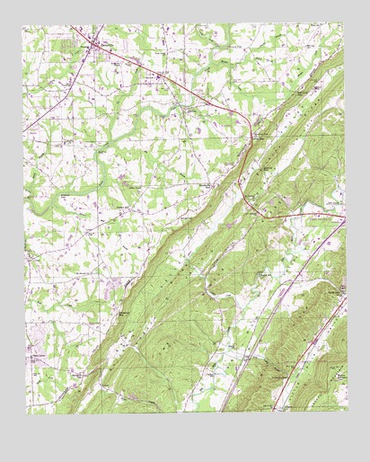
Chavies, AL USGS Topographic Map
Click on map above to begin viewing in our Map Viewer.

This topographic map contains these locations and features:
Feature Name Type Latitude Longitude GNIS ID View Map
Antioch CemeteryCemeteryN34.4817°W85.7597°150070View Map
Beasons Mill (historical)LocaleN34.4409°W85.7616°150651View Map
Big BranchStreamN34.4612°W85.8427°150103View Map
Big RidgeRidgeN34.3948°W85.7758°150107View Map
Blake Junior High SchoolSchoolN34.4993°W85.7586°150115View Map
Bohannon FordCrossingN34.4459°W85.8611°156089View Map
Bootsville (historical)Populated PlaceN34.4293°W85.8111°150654View Map
Bootsville GapGapN34.4470°W85.8019°150119View Map
Broadway ChurchChurchN34.4926°W85.8480°150124View Map
Brown BranchStreamN34.4443°W85.8727°150129View Map
Brown ChurchChurchN34.4620°W85.8577°158796View Map
Brown School (historical)SchoolN34.4618°W85.8575°1700290View Map
Bynum Mill BranchStreamN34.4420°W85.8647°150136View Map
Caney CreekStreamN34.4926°W85.8000°150144View Map
ChaviesPopulated PlaceN34.4729°W85.8136°150151View Map
Chavies ChurchChurchN34.4712°W85.8111°150660View Map
Chavies GapGapN34.4531°W85.7822°150152View Map
Chitwood GapGapN34.4073°W85.8389°150155View Map
City of RainsvilleCivilN34.4939°W85.8435°2404589View Map
CollbranPopulated PlaceN34.3759°W85.7786°156202View Map
Collbran GapGapN34.3865°W85.7730°150162View Map
Davis ChapelChurchN34.4131°W85.7514°150187View Map
Davis GapGapN34.4134°W85.7522°150188View Map
Davis GapGapN34.4631°W85.7866°150189View Map
De Kalb Annex SchoolSchoolN34.4884°W85.8394°150674View Map
De Kalb Vocational SchoolSchoolN34.4890°W85.8402°150681View Map
DeKalb CountyCivilN34.4598°W85.8041°161550View Map
Dekalb County Sheriff's OfficeBuildingN34.4181°W85.7730°2751781View Map
Dekalb Regional Medical CenterHospitalN34.4414°W85.7559°150677View Map
Fort Payne Water WorksLocaleN34.4415°W85.7516°164330View Map
Franklin FordCrossingN34.4929°W85.7958°156380View Map
Goza Church (historical)ChurchN34.4926°W85.7675°1700295View Map
Gravel Hill ChurchChurchN34.3768°W85.7786°150261View Map
Grove ChurchChurchN34.4037°W85.8505°150267View Map
GuestPopulated PlaceN34.4243°W85.8733°150269View Map
Guest ChurchChurchN34.4245°W85.8730°158282View Map
Hawkins SpringSpringN34.4789°W85.7623°150283View Map
HortonPopulated PlaceN34.3845°W85.8464°156498View Map
Hughes MillPopulated PlaceN34.4190°W85.7839°156506View Map
Ivy CreekStreamN34.4620°W85.8411°150303View Map
Jacks CreekStreamN34.4079°W85.7902°150305View Map
Killian MillPopulated PlaceN34.3873°W85.8019°156556View Map
Lands CrossroadsPopulated PlaceN34.4798°W85.8566°150325View Map
Little Wills Valley BranchStreamN34.3948°W85.7952°150351View Map
Log Cabin School (historical)SchoolN34.3954°W85.7880°157526View Map
Long HollowValleyN34.4184°W85.8047°150353View Map
Luna (historical)Populated PlaceN34.4465°W85.8277°150713View Map
LydiaPopulated PlaceN34.4331°W85.8508°156641View Map
Macedonia Church (historical)ChurchN34.4854°W85.7805°1700298View Map
McCurdy GapGapN34.4781°W85.7675°150376View Map
Miller ChapelChurchN34.4479°W85.8294°158869View Map
Morgan CreekStreamN34.4876°W85.8022°150390View Map
Mount BrandonSummitN34.3851°W85.7533°150122View Map
Mount Herman CemeteryCemeteryN34.4395°W85.7864°150394View Map
Mount Herman ChurchChurchN34.4429°W85.7855°150395View Map
Mount Moriah ChurchChurchN34.4201°W85.8489°150397View Map
Mountain View ChurchChurchN34.4634°W85.7847°150411View Map
Mountain View Memorial CemeteryCemeteryN34.4531°W85.7964°159002View Map
Peeks CornerPopulated PlaceN34.3931°W85.8730°152865View Map
Peeks Corner Fire Protection AuthorityBuildingN34.3929°W85.8712°2683160View Map
Peeks Corner School (historical)SchoolN34.3937°W85.8736°1700302View Map
Pine RidgePopulated PlaceN34.4395°W85.7844°158292View Map
Pine Ridge ChurchChurchN34.4493°W85.7905°158293View Map
Pine Ridge Fire ProtectionBuildingN34.4445°W85.7844°2682845View Map
PlainviewPopulated PlaceN34.4831°W85.8205°150459View Map
Plainview SchoolSchoolN34.4829°W85.8222°150732View Map
Pleasant HillPopulated PlaceN34.4401°W85.8339°150460View Map
Pleasant Hill ChurchChurchN34.4404°W85.8333°158294View Map
RainsvillePopulated PlaceN34.4943°W85.8477°150475View Map
Rainsville ChurchChurchN34.4976°W85.8472°157536View Map
Rainsville Civic CenterBuildingN34.4840°W85.8241°150738View Map
Rainsville Post OfficePost OfficeN34.4995°W85.8528°2788922View Map
Rainsville Volunteer Fire DepartmentBuildingN34.4975°W85.8508°2682887View Map
Robertson Chapel United Methodist ChurchChurchN34.4879°W85.8372°158912View Map
Shankle BranchStreamN34.4865°W85.7944°150507View Map
Shiloh ChurchChurchN34.3956°W85.7939°150509View Map
Shiloh Fire DepartmentBuildingN34.4660°W85.8733°2683421View Map
Shinbone RidgeRidgeN34.4585°W85.7761°2791501View Map
Sparks BranchStreamN34.4479°W85.8725°150524View Map
Suttell FordCrossingN34.4593°W85.8466°157131View Map
Swindell GapLocaleN34.4376°W85.8152°150545View Map
The Middle RidgesRidgeN34.4165°W85.8002°150550View Map
Town Creek CemeteryCemeteryN34.4915°W85.8189°1730312View Map
Town Creek ChurchChurchN34.4904°W85.8194°150556View Map
Town of Pine RidgeCivilN34.4489°W85.7807°2407119View Map
Winston GapGapN34.3873°W85.8527°150597View Map
Wooten BranchStreamN34.4879°W85.7891°150601View Map
WVSM-AM (Rainsville)TowerN34.4990°W85.8427°161076View Map
WZOB-AM (Fort Payne)TowerN34.4398°W85.7533°161073View Map

Note: Coordinates in the location and feature list above are referenced to NAD83 datum.


Copyright (C) 2008-2024 Ryan Niemi / Sunset Dynamics ... All Rights Reserved