TopoQuest Logo
Do you find TopoQuest useful?
Help keep TopoQuest running and adding new maps/features by donating!
Bitcoin:  19c7KJd3qBynnjoSw5npx9KScwjBe4ifkT
Litecoin:  LXs6TkuXGGXo1vDsWCkWVdjQX94eUKd6ui
Home View Maps Find Maps Find Places Resources & Links


Dyer Gap, Georgia Topographic Map

USGS Map Title: Dyer Gap, GA
USGS Map MRC: 34084G5
DRG (GeoTIFF) Download: o34084g5.tif


Neighboring USGS Topographic Map Quads:


  Tennga, GA  
34084H6
 

  Hemp Top, GA  
34084H5
 

  Epworth, GA  
34084H4
 

  Crandall, GA  
34084G6
 

  Dyer Gap, GA  
34084G5
 

  Cashes Valley, GA  
34084G4
 

  Ramhurst, GA  
34084F6
 

  Webb, GA  
34084F5
 

  Ellijay, GA  
34084F4


Map MRC Location:

N35°
W85°
N35°
W84°
H8 H7 H6 H5 H4 H3 H2 H1
G8 G7 G6 G5 G4 G3 G2 G1
F8 F7 F6 F5 F4 F3 F2 F1
E8 E7 E6 E5 E4 E3 E2 E1
D8 D7 D6 D5 D4 D3 D2 D1
C8 C7 C6 C5 C4 C3 C2 C1
B8 B7 B6 B5 B4 B3 B2 B1
A8 A7 A6 A5 A4 A3 A2 A1
N34°
W85°
N34°
W84°

Dyer Gap, GA USGS 1:24K Topographic Map Preview:
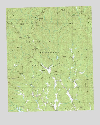
Dyer Gap, GA USGS Topographic Map
Click on map above to begin viewing in our Map Viewer.

This topographic map contains these locations and features:
Feature Name Type Latitude Longitude GNIS ID View Map
Alaculsy GapGapN34.8420°W84.5310°326926View Map
Barnes CreekStreamN34.7959°W84.5630°327010View Map
Barnes Creek Camping AreaLocaleN34.8281°W84.5830°352908View Map
Bear CreekStreamN34.8120°W84.5594°327027View Map
Bear Creek TrailTrailN34.8276°W84.5647°352909View Map
Bear Pen GapGapN34.8342°W84.5644°330484View Map
Bee KnobSummitN34.7534°W84.5394°330510View Map
Betty CreekStreamN34.8481°W84.5633°327093View Map
Betty GapGapN34.8542°W84.5810°327094View Map
Betty MountainSummitN34.8587°W84.5783°331153View Map
Birch CreekStreamN34.8645°W84.5922°330477View Map
Boatwright BranchStreamN34.8042°W84.6149°330473View Map
Brushy GapGapN34.8520°W84.5352°330487View Map
Buddy Cove GapGapN34.8715°W84.5408°330488View Map
Buzzard Roost CreekStreamN34.7595°W84.6169°326905View Map
Carroll CreekStreamN34.7729°W84.5377°327365View Map
Chestnut CreekStreamN34.8676°W84.6008°330478View Map
Chestnut LeadRidgeN34.8584°W84.6027°330490View Map
Conasauga (historical)Populated PlaceN34.7823°W84.5913°1704602View Map
Cowpen CreekStreamN34.8645°W84.5922°330470View Map
Crenshaw BranchStreamN34.8376°W84.5555°327553View Map
Crenshaw GapGapN34.8620°W84.5291°327554View Map
Davenport LakeReservoirN34.7877°W84.5341°336858View Map
Demps MountainSummitN34.7892°W84.5741°331539View Map
Double TopSummitN34.8073°W84.5944°331581View Map
Douglas MountainSummitN34.7731°W84.5094°331582View Map
Dyer CemeteryCemeteryN34.8692°W84.5146°327722View Map
Dyer CreekStreamN34.8301°W84.5494°327723View Map
Dyer GapGapN34.8681°W84.5144°327724View Map
East Mountaintown CreekStreamN34.7509°W84.5563°328563View Map
Emery Creek TrailTrailN34.8437°W84.6213°330672View Map
Gates ChapelChurchN34.7942°W84.5560°355985View Map
Gates Chapel United Methodist Church CemeteryCemeteryN34.7943°W84.5567°2681115View Map
Gibson CreekStreamN34.7973°W84.5255°330481View Map
Gibson LakeReservoirN34.7801°W84.6033°339692View Map
Gibson Lake DamDamN34.7801°W84.6033°339691View Map
Gilmer County Fire Department Station 8BuildingN34.7528°W84.5607°2603741View Map
Granny MountainSummitN34.7990°W84.5552°330486View Map
Halloway GapGapN34.8290°W84.5010°328041View Map
Harkins CreekStreamN34.7526°W84.6099°328064View Map
Harper CreekStreamN34.7904°W84.5335°328073View Map
Heddy CreekStreamN34.8165°W84.5519°330480View Map
Henry Grady SchoolSchoolN34.7592°W84.5630°328111View Map
Hill LakeReservoirN34.8117°W84.5549°336860View Map
Hills LakeLakeN34.8140°W84.5515°330475View Map
Holly Creek GapGapN34.8154°W84.5897°328200View Map
Indian Grave KnobSummitN34.8134°W84.5433°332058View Map
John Rogers CreekStreamN34.7526°W84.6099°326907View Map
Law GroundsLocaleN34.7851°W84.5622°328456View Map
Little Bear CreekStreamN34.8242°W84.5660°328524View Map
Loggy FlatsFlatN34.8229°W84.5102°330489View Map
Moreland BranchStreamN34.8176°W84.6022°330474View Map
Mount Nebo CemeteryCemeteryN34.7851°W84.5466°328976View Map
MountaintownPopulated PlaceN34.7556°W84.5602°330476View Map
Mountaintown ChurchChurchN34.7501°W84.5633°328936View Map
Mountaintown Creek TrailTrailN34.8415°W84.5555°352944View Map
Mountaintown Creek Watershed Dam Number OneDamN34.7867°W84.5333°336857View Map
Mountaintown Creek Watershed Dam Number ThreeDamN34.7551°W84.5816°336861View Map
Mountaintown Creek Watershed Dam Number TwoDamN34.8140°W84.5513°336859View Map
Mountaintown Watershed Lake Number ThreeReservoirN34.7551°W84.5816°336862View Map
Mulberry GapGapN34.7962°W84.6074°328947View Map
Nine Mile United Methodist Church CemeteryCemeteryN34.7698°W84.5830°2681154View Map
Ninemile ChurchChurchN34.7690°W84.5830°329037View Map
North Gilmer DivisionCivilN34.7783°W84.5212°1936187View Map
Painter GapGapN34.8001°W84.5741°329125View Map
Parks RidgeRidgeN34.8254°W84.5769°329136View Map
Pickett CreekStreamN34.7640°W84.5277°330472View Map
Pink KnobSummitN34.8470°W84.5227°332689View Map
Pleasant HillPopulated PlaceN34.7540°W84.6022°332711View Map
Pleasant Hill Baptist ChurchChurchN34.7540°W84.6019°352957View Map
Pleasant Hill Baptist Church CemeteryCemeteryN34.7536°W84.6025°2681160View Map
Poplar Springs BranchStreamN34.8662°W84.5908°330471View Map
Poplar Springs GapGapN34.8612°W84.5774°330483View Map
Potatopatch CreekStreamN34.8662°W84.5972°330479View Map
Potatopatch MountainSummitN34.8376°W84.5991°332743View Map
Potatopatch SpringSpringN34.8415°W84.5966°330494View Map
Rainbow LakeReservoirN34.7521°W84.6080°329357View Map
Rainbow Lake DamDamN34.7517°W84.6083°336820View Map
Rattlesnake LeadRidgeN34.8187°W84.5069°330492View Map
Rich KnobSummitN34.8673°W84.5485°332842View Map
Rich Knob BranchStreamN34.8481°W84.5474°329428View Map
Rocky FaceSummitN34.8276°W84.6105°332894View Map
Saddle RidgeRidgeN34.8467°W84.5441°329558View Map
Sam Jones GapGapN34.8615°W84.5777°330482View Map
Sassafras GapGapN34.8470°W84.5172°329600View Map
Snaggy LeadRidgeN34.7990°W84.5749°330491View Map
Stillhouse BranchStreamN34.7826°W84.5913°329837View Map
Stone Pile GapGapN34.7559°W84.5135°329850View Map
Turkey MountainSummitN34.7906°W84.6113°333280View Map
Wildcat LeadRidgeN34.8209°W84.5216°330493View Map
Willys CreekStreamN34.7526°W84.6099°330303View Map
Wisnaint MountainSummitN34.7523°W84.5185°330485View Map
Wolfpen GapGapN34.7867°W84.5058°330347View Map
Youther CreekStreamN34.7948°W84.5147°330419View Map
Zion Hill Baptist Church CemeteryCemeteryN34.7854°W84.5253°2681183View Map
Zion Hill ChurchChurchN34.7870°W84.5255°330426View Map

Note: Coordinates in the location and feature list above are referenced to NAD83 datum.


Copyright (C) 2008-2025 Ryan Niemi / Sunset Dynamics ... All Rights Reserved