TopoQuest Logo
Do you find TopoQuest useful?
Help keep TopoQuest running and adding new maps/features by donating!
Bitcoin:  19c7KJd3qBynnjoSw5npx9KScwjBe4ifkT
Litecoin:  LXs6TkuXGGXo1vDsWCkWVdjQX94eUKd6ui
Home View Maps Find Maps Find Places Resources & Links


Earleville, Maryland Topographic Map

USGS Map Title: Earleville, MD
USGS Map MRC: 39075D8
DRG (GeoTIFF) Download: o39075d8.tif


Neighboring USGS Topographic Map Quads:


  Havre De Grace, MD  
39076E1
 

  North East, MD  
39075E8
 

  Elkton, MD  
39075E7
 

  Spesutie, MD  
39076D1
 

  Earleville, MD  
39075D8
 

  Cecilton, MD  
39075D7
 

  Betterton, MD  
39076C1
 

  Galena, MD  
39075C8
 

  Millington, MD  
39075C7


Map MRC Location:

N40°
W76°
N40°
W75°
H8 H7 H6 H5 H4 H3 H2 H1
G8 G7 G6 G5 G4 G3 G2 G1
F8 F7 F6 F5 F4 F3 F2 F1
E8 E7 E6 E5 E4 E3 E2 E1
D8 D7 D6 D5 D4 D3 D2 D1
C8 C7 C6 C5 C4 C3 C2 C1
B8 B7 B6 B5 B4 B3 B2 B1
A8 A7 A6 A5 A4 A3 A2 A1
N39°
W76°
N39°
W75°

Earleville, MD USGS 1:24K Topographic Map Preview:
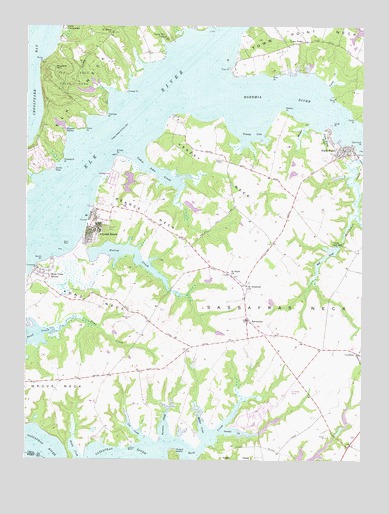
Earleville, MD USGS Topographic Map
Click on map above to begin viewing in our Map Viewer.

This topographic map contains these locations and features:
Feature Name Type Latitude Longitude GNIS ID View Map
Antler CreekStreamN39.4829°W75.9733°589063View Map
Arnold PointCapeN39.4621°W75.9658°582922View Map
Back CreekStreamN39.4948°W75.9488°596114View Map
Back CreekStreamN39.4821°W75.9691°588528View Map
Back CreekStreamN39.3790°W75.9483°582982View Map
Battery PointCapeN39.4754°W75.9041°583057View Map
Battery Point FarmsPopulated PlaceN39.4682°W75.9041°589076View Map
Bay View EstatesPopulated PlaceN39.4251°W75.9988°589078View Map
Beach FisheryLocaleN39.4315°W75.9958°589079View Map
Beaver Dam FisheryLocaleN39.4704°W75.9955°589080View Map
Bohemia AcresPopulated PlaceN39.4618°W75.8888°589092View Map
Bohemia Country ClubLocaleN39.4576°W75.8969°589093View Map
Bohemia RiverStreamN39.4829°W75.9405°583317View Map
Bohemia River MarinaLocaleN39.4873°W75.8955°595188View Map
Bohemia Vista MarinaLocaleN39.4862°W75.9011°595187View Map
Buttonwood BeachLocaleN39.4584°W75.9677°588544View Map
Cabin John CreekStreamN39.4643°W75.9608°588754View Map
Camp BrissonLocaleN39.4871°W75.9661°589112View Map
Camp Chesapeake (historical)LocaleN39.4993°W75.9855°591678View Map
Camp Red Mill (historical)LocaleN39.4371°W75.8861°595089View Map
Cassidy WharfLocaleN39.3784°W75.9616°583614View Map
Cassidy WharfPopulated PlaceN39.3843°W75.9605°589121View Map
Cassidy Wharf FarmLocaleN39.3803°W75.9600°2704524View Map
Chestnut Lane FarmsLocaleN39.4022°W75.9592°2704536View Map
Collins FisheryLocaleN39.4901°W75.9530°589168View Map
Cox CreekStreamN39.3804°W75.9541°583946View Map
Crawford Acres (historical)Populated PlaceN39.4065°W75.8830°595105View Map
District 1, CeciltonCivilN39.4150°W75.9128°1929415View Map
Dowdel CreekStreamN39.3832°W75.9263°584144View Map
Downs BranchStreamN39.4548°W75.9505°596117View Map
EarlevillePopulated PlaceN39.4154°W75.9174°584214View Map
Earleville Post OfficePost OfficeN39.4132°W75.9144°595386View Map
Earleville Wildlife Management AreaParkN39.4379°W75.9011°589198View Map
Elk Neck State ParkParkN39.4846°W75.9830°588922View Map
Ford FarmsLocaleN39.4139°W75.9097°2704531View Map
Ford LandingLocaleN39.4740°W75.9466°589244View Map
Foreman CreekStreamN39.3807°W75.9480°584440View Map
Frazers Lake DamDamN39.4368°W75.8847°594395View Map
Goldsmiths BranchStreamN39.4529°W75.9427°596119View Map
Green BriarPopulated PlaceN39.4932°W75.8899°589273View Map
Greenbush PointCapeN39.4612°W75.9869°584757View Map
Grove NeckCapeN39.3973°W75.9927°584781View Map
Grove Neck School (historical)SchoolN39.4065°W75.9608°589280View Map
Hack PointPopulated PlaceN39.4632°W75.8811°590401View Map
Hacks Point AcresPopulated PlaceN39.4668°W75.8913°589284View Map
Hacks Point Fire CompanyBuildingN39.4609°W75.8921°2085715View Map
Hexton Farms AirportAirportN39.3768°W75.9047°595251View Map
Honeysuckle KnollPopulated PlaceN39.4621°W75.8816°589313View Map
Huckleberry PointCapeN39.4562°W75.9499°596120View Map
Indian AcresPopulated PlaceN39.3873°W75.9149°589319View Map
Indian Cabin FisheryLocaleN39.4515°W75.9999°589320View Map
Jacobs NoseCapeN39.4587°W75.9899°585188View Map
Jamisons School (historical)SchoolN39.4379°W75.9083°589330View Map
John TownPopulated PlaceN39.4257°W75.9186°589332View Map
Knight IslandIslandN39.3757°W75.9199°585328View Map
Long PointCapeN39.4715°W75.8869°585597View Map
Long Point MarinaLocaleN39.4666°W75.8841°2503447View Map
Mauldin MountainSummitN39.4873°W75.9902°590763View Map
McGill CreekStreamN39.3812°W75.9319°585761View Map
Mill PondLakeN39.4338°W75.8882°585872View Map
Morgan CreekStreamN39.4712°W75.8938°585962View Map
Mount HarmonPopulated PlaceN39.3826°W75.9369°589378View Map
Mount Pleasant FarmLocaleN39.4112°W75.9205°589384View Map
Mulberry Dock (historical)LocaleN39.4704°W75.8863°596121View Map
Old Hack PointCapeN39.4662°W75.8774°586308View Map
Panagopulos Farm Pond DamDamN39.4484°W75.9380°594530View Map
Parlor PointCapeN39.4737°W75.8783°586420View Map
Pearce CreekStreamN39.4387°W75.9791°588799View Map
Pearce Creek Disposal Area DamDamN39.4318°W75.9830°594463View Map
Pearce Creek Disposal Area LakeReservoirN39.4359°W75.9697°594464View Map
Pearce NeckCapeN39.4457°W75.9541°588800View Map
Pond NeckCapeN39.4215°W75.9749°586640View Map
Pooles CreekStreamN39.4821°W75.8874°586644View Map
Queens PointCapeN39.3848°W75.9252°589466View Map
Reybold WharfLocaleN39.4479°W75.9766°589471View Map
Rich PointCapeN39.4859°W75.9086°586820View Map
Richmonds MarinaLocaleN39.4621°W75.8769°2503602View Map
Rocky PointCapeN39.4893°W75.9944°586910View Map
Rogues HarborBayN39.4696°W75.9838°586917View Map
Saint Marks ChurchChurchN39.4982°W75.9680°587085View Map
Saint Pauls ChurchChurchN39.4282°W75.9236°587132View Map
Saint Pauls United Methodist CemeteryCemeteryN39.4283°W75.9232°589499View Map
Saint Stephens ChurchChurchN39.4254°W75.9177°587155View Map
Saint Stephens Episcopal CemeteryCemeteryN39.4256°W75.9171°589501View Map
Sandy Hill CampLocaleN39.4965°W75.9480°587198View Map
Sassafras NeckCapeN39.4190°W75.8980°587220View Map
Sassafras Neck Methodist Church (historical)ChurchN39.4287°W75.9241°1712992View Map
Scotchmans Creek BridgeBridgeN39.4612°W75.8755°1712993View Map
Scotchmans GlenPopulated PlaceN39.4543°W75.8949°589505View Map
Snow Hill (historical)Populated PlaceN39.4940°W75.8761°589511View Map
Stemmers Run Wildlife Management Area (historical)ParkN39.4296°W75.9816°595107View Map
Stony PointCapeN39.4707°W75.9783°587586View Map
Stony PointCapeN39.4790°W75.8849°587587View Map
Sunset PointPopulated PlaceN39.4221°W75.9919°589525View Map
Sweet Potato CreekStreamN39.4696°W75.8902°587672View Map
Thackery PointCapeN39.4743°W75.9711°587730View Map
The Woods of Town PointPopulated PlaceN39.4923°W75.9183°589544View Map
Timber NeckCapeN39.4932°W75.9744°589549View Map
Timber PointCapeN39.4812°W75.9627°587805View Map
Tower PointPopulated PlaceN39.4987°W75.9149°589556View Map
Town PointPopulated PlaceN39.4957°W75.8963°591419View Map
Town PointCapeN39.4879°W75.9241°587852View Map
Town Point Methodist ChurchChurchN39.4987°W75.8997°595185View Map
Town Point NeckCapeN39.4993°W75.8911°587854View Map
Two RiversPopulated PlaceN39.4896°W75.9055°589565View Map
Two Rivers MarinaLocaleN39.4873°W75.9036°595186View Map
Veazey CoveBayN39.4687°W75.9158°587998View Map
Veazey Family CemeteryCemeteryN39.4616°W75.9270°587997View Map
Veazey FisheryLocaleN39.4590°W75.9686°589576View Map
Veazey NeckCapeN39.4579°W75.9294°587999View Map
Wapiti CreekStreamN39.4821°W75.9691°589581View Map
West View ShoresPopulated PlaceN39.4293°W75.9963°595100View Map
White BanksCliffN39.4801°W75.9941°588530View Map
White Crystal BeachPopulated PlaceN39.4418°W75.9747°595090View Map
Wil-O-Mar FarmsLocaleN39.4050°W75.9181°2704526View Map
Wilsons FisheryLocaleN39.4857°W75.9580°589606View Map
Wroth PointCapeN39.4318°W75.9941°588358View Map

Note: Coordinates in the location and feature list above are referenced to NAD83 datum.


Copyright (C) 2008-2025 Ryan Niemi / Sunset Dynamics ... All Rights Reserved