TopoQuest Logo
Do you find TopoQuest useful?
Help keep TopoQuest running and adding new maps/features by donating!
Bitcoin:  19c7KJd3qBynnjoSw5npx9KScwjBe4ifkT
Litecoin:  LXs6TkuXGGXo1vDsWCkWVdjQX94eUKd6ui
Home View Maps Find Maps Find Places Resources & Links


Millington, Maryland Topographic Map

USGS Map Title: Millington, MD
USGS Map MRC: 39075C7
DRG (GeoTIFF) Download: o39075c7.tif


Neighboring USGS Topographic Map Quads:


  Earleville, MD  
39075D8
 

  Cecilton, MD  
39075D7
 

  Middletown, DE  
39075D6
 

  Galena, MD  
39075C8
 

  Millington, MD  
39075C7
 

  Clayton, DE  
39075C6
 

  Church Hill, MD  
39075B8
 

  Sudlersville, MD  
39075B7
 

  Kenton, DE  
39075B6


Map MRC Location:

N40°
W76°
N40°
W75°
H8 H7 H6 H5 H4 H3 H2 H1
G8 G7 G6 G5 G4 G3 G2 G1
F8 F7 F6 F5 F4 F3 F2 F1
E8 E7 E6 E5 E4 E3 E2 E1
D8 D7 D6 D5 D4 D3 D2 D1
C8 C7 C6 C5 C4 C3 C2 C1
B8 B7 B6 B5 B4 B3 B2 B1
A8 A7 A6 A5 A4 A3 A2 A1
N39°
W76°
N39°
W75°

Millington, MD USGS 1:24K Topographic Map Preview:
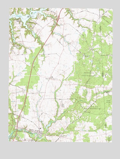
Millington, MD USGS Topographic Map
Click on map above to begin viewing in our Map Viewer.

This topographic map contains these locations and features:
Feature Name Type Latitude Longitude GNIS ID View Map
Andover BranchStreamN39.2568°W75.8391°597011View Map
Asbury United Methodist ChurchChurchN39.2587°W75.8377°591808View Map
Beachwood GlenPopulated PlaceN39.3626°W75.8616°591811View Map
Black Bottom BranchStreamN39.2887°W75.7872°595207View Map
Bright Helmstone FarmsLocaleN39.3358°W75.7969°2704520View Map
Budd LandingLocaleN39.3734°W75.8383°589846View Map
Chapel of the Holy CrossChurchN39.2593°W75.8372°591829View Map
Coldwell CornersLocaleN39.3668°W75.7649°213814View Map
Community Volunteer Fire Company of Millington Station 2BuildingN39.2604°W75.8376°2085744View Map
Coppin CreekStreamN39.3704°W75.8491°589181View Map
Cypress BranchStreamN39.2537°W75.8347°213850View Map
Cypress BranchStreamN39.2723°W75.8172°584002View Map
Cypress Mill Pond DamDamN39.2618°W75.8280°594382View Map
D'Angelo Airport (historical)AirportN39.3391°W75.7688°2443756View Map
Deep PointCapeN39.3682°W75.8658°589192View Map
District 1, MasseyCivilN39.3100°W75.8344°1929422View Map
Drakes Mill (historical)LocaleN39.3723°W75.8038°591851View Map
Edmonds CreekStreamN39.2607°W75.8310°593903View Map
El Dondo AcresPopulated PlaceN39.3346°W75.8555°591855View Map
Four CornersLocaleN39.2515°W75.8477°597428View Map
Fox Hole LandingLocaleN39.3740°W75.8294°590239View Map
Galena Volunteer Fire Company Station 3BuildingN39.3420°W75.8722°2087237View Map
GoltsPopulated PlaceN39.3368°W75.7747°584636View Map
Golts Post OfficePost OfficeN39.3384°W75.7749°595426View Map
Gregg NeckPopulated PlaceN39.3626°W75.8663°588534View Map
Halls Neck PointCapeN39.3687°W75.8499°589285View Map
Hen IslandIslandN39.3698°W75.8480°584927View Map
Hen Island CreekStreamN39.3690°W75.8488°588416View Map
Higman Mill (historical)LocaleN39.2568°W75.8385°591889View Map
Holiness Christian ChurchChurchN39.2601°W75.8399°591890View Map
Jacobs CreekStreamN39.3709°W75.8360°585187View Map
John Wesley United Methodist ChurchChurchN39.2548°W75.8369°591899View Map
Jones LandingLocaleN39.2593°W75.8541°597623View Map
Judge PointCapeN39.3676°W75.8552°589335View Map
MasseyPopulated PlaceN39.3098°W75.8252°590760View Map
Massey AerodromeAirportN39.3023°W75.8013°2443758View Map
Massey Post OfficePost OfficeN39.3087°W75.8255°595435View Map
Mill PondLakeN39.3461°W75.8694°585871View Map
Mill PondReservoirN39.2656°W75.8256°593908View Map
MillingtonPopulated PlaceN39.2582°W75.8372°585893View Map
Millington Elementary SchoolSchoolN39.2627°W75.8360°591928View Map
Millington ParkParkN39.2626°W75.8383°591929View Map
Millington Post OfficePost OfficeN39.2584°W75.8355°595437View Map
Millington Town HallBuildingN39.2587°W75.8369°591930View Map
Millington Wildlife Demonstration AreaParkN39.2776°W75.7669°585894View Map
Mills BranchStreamN39.2593°W75.8683°597754View Map
Mission ChurchChurchN39.2576°W75.8097°585911View Map
Morton PointCapeN39.3712°W75.8355°593909View Map
Olivet HillPopulated PlaceN39.3382°W75.8660°590947View Map
Peacock CornersPopulated PlaceN39.2551°W75.8122°590989View Map
Piney RidgePopulated PlaceN39.2596°W75.8602°596084View Map
Pleasant CovePopulated PlaceN39.3682°W75.8394°591937View Map
Riley Mill Pond DamDamN39.3501°W75.8697°594538View Map
Rivers EdgePopulated PlaceN39.2626°W75.8599°591947View Map
Rob Vanary ParkParkN39.2601°W75.8435°591948View Map
Saint Clements ChurchChurchN39.3084°W75.8213°586995View Map
Saint Clements Episcopal CemeteryCemeteryN39.3084°W75.8206°591960View Map
SassafrasPopulated PlaceN39.3732°W75.8024°591231View Map
Schlosser AirportAirportN39.3627°W75.8125°2443754View Map
School Number 1 (historical)SchoolN39.3598°W75.8091°591970View Map
School Number 7 (historical)SchoolN39.2548°W75.8127°591984View Map
School Number 8 (historical)SchoolN39.3079°W75.8163°591987View Map
ShorewoodPopulated PlaceN39.3584°W75.8516°588537View Map
Shorewood EstatesPopulated PlaceN39.3571°W75.8502°591991View Map
Swanton (historical)Populated PlaceN39.3648°W75.8341°591995View Map
Swantown CreekStreamN39.3662°W75.8563°587668View Map
Town of MillingtonCivilN39.2583°W75.8402°2391303View Map
Unicorn BranchStreamN39.2548°W75.8716°598194View Map
Unicorn Branch DamDamN39.2501°W75.8663°594304View Map
Unicorn CrossingPopulated PlaceN39.2512°W75.8547°596110View Map
Unicorn LakeReservoirN39.2501°W75.8663°594305View Map
Wesley CemeteryCemeteryN39.2591°W75.8441°595127View Map
Wilson PointCapeN39.3665°W75.8491°588274View Map
Wilson Point Wharf (historical)LocaleN39.3662°W75.8497°592009View Map

Note: Coordinates in the location and feature list above are referenced to NAD83 datum.


Copyright (C) 2008-2024 Ryan Niemi / Sunset Dynamics ... All Rights Reserved