TopoQuest Logo
Do you find TopoQuest useful?
Help keep TopoQuest running and adding new maps/features by donating!
Bitcoin:  19c7KJd3qBynnjoSw5npx9KScwjBe4ifkT
Litecoin:  LXs6TkuXGGXo1vDsWCkWVdjQX94eUKd6ui
Home View Maps Find Maps Find Places Resources & Links


Earlville, Illinois Topographic Map

USGS Map Title: Earlville, IL
USGS Map MRC: 41088E8
DRG (GeoTIFF) Download: o41088e8.tif


Neighboring USGS Topographic Map Quads:


  Compton, IL  
41089F1
 

  Paw Paw, IL  
41088F8
 

  Shabbona Grove, IL  
41088F7
 

  Mendota East, IL  
41089E1
 

  Earlville, IL  
41088E8
 

  Leland, IL  
41088E7
 

  Troy Grove, IL  
41089D1
 

  Prairie Center, IL  
41088D8
 

  Wedron, IL  
41088D7


Map MRC Location:

N42°
W89°
N42°
W88°
H8 H7 H6 H5 H4 H3 H2 H1
G8 G7 G6 G5 G4 G3 G2 G1
F8 F7 F6 F5 F4 F3 F2 F1
E8 E7 E6 E5 E4 E3 E2 E1
D8 D7 D6 D5 D4 D3 D2 D1
C8 C7 C6 C5 C4 C3 C2 C1
B8 B7 B6 B5 B4 B3 B2 B1
A8 A7 A6 A5 A4 A3 A2 A1
N41°
W89°
N41°
W88°

Earlville, IL USGS 1:24K Topographic Map Preview:
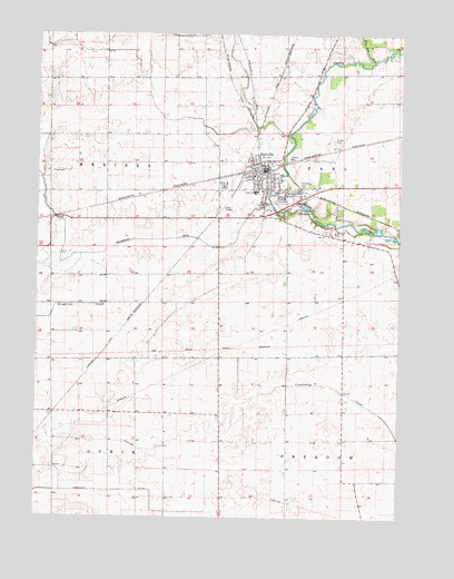
Earlville, IL USGS Topographic Map
Click on map above to begin viewing in our Map Viewer.

This topographic map contains these locations and features:
Feature Name Type Latitude Longitude GNIS ID View Map
Austin School (historical)SchoolN41.5267°W88.9942°1718872View Map
B & C AirportAirportN41.5928°W88.9673°2679044View Map
Campbell School (historical)SchoolN41.5273°W88.9559°1718871View Map
Carter CemeteryCemeteryN41.5976°W88.8979°405649View Map
City of EarlvilleCivilN41.5881°W88.9230°2394593View Map
Earl CemeteryCemeteryN41.5739°W88.8992°407587View Map
EarlvillePopulated PlaceN41.5895°W88.9220°407590View Map
Earlville Airport (historical)AirportN41.5670°W88.9479°427241View Map
Earlville Fire DistrictBuildingN41.5908°W88.9204°2681792View Map
Earlville High SchoolSchoolN41.5842°W88.9251°1718869View Map
Earlville Police DepartmentBuildingN41.5902°W88.9237°2756729View Map
Earlville Post OfficePost OfficeN41.5894°W88.9230°2788587View Map
Paw Paw RunStreamN41.6181°W88.8848°421996View Map
Saint Theresa CemeteryCemeteryN41.5859°W88.9092°417811View Map
Sellers Airport (historical)AirportN41.5139°W88.9376°427873View Map
Smith School (historical)SchoolN41.5550°W88.9951°1718870View Map
Sutphens RunStreamN41.5814°W88.9201°419435View Map
Tomahawk DitchCanalN41.5070°W88.9717°424459View Map
Township of EarlCivilN41.5863°W88.8777°428927View Map
Township of MeridenCivilN41.5840°W88.9944°429357View Map
Tripp CemeteryCemeteryN41.5892°W88.9956°419881View Map
Younglove/Otterbach AirportAirportN41.5395°W88.9998°2770506View Map

Note: Coordinates in the location and feature list above are referenced to NAD83 datum.


Copyright (C) 2008-2025 Ryan Niemi / Sunset Dynamics ... All Rights Reserved