TopoQuest Logo
Do you find TopoQuest useful?
Help keep TopoQuest running and adding new maps/features by donating!
Bitcoin:  19c7KJd3qBynnjoSw5npx9KScwjBe4ifkT
Litecoin:  LXs6TkuXGGXo1vDsWCkWVdjQX94eUKd6ui
Home View Maps Find Maps Find Places Resources & Links


East Corinth, Vermont Topographic Map

USGS Map Title: East Corinth, VT
USGS Map MRC: 44072A2
DRG (GeoTIFF) Download: o44072a2.tif


Neighboring USGS Topographic Map Quads:


  Knox Mountain, VT  
44072B3
 

  Groton, VT  
44072B2
 

  Woodsville, NH  
44072B1
 

  West Topsham, VT  
44072A3
 

  East Corinth, VT  
44072A2
 

  Newbury, VT  
44072A1
 

  Vershire, VT  
43072H3
 

  Fairlee, VT  
43072H2
 

  Piermont, NH  
43072H1


Map MRC Location:

N45°
W73°
N45°
W72°
H8 H7 H6 H5 H4 H3 H2 H1
G8 G7 G6 G5 G4 G3 G2 G1
F8 F7 F6 F5 F4 F3 F2 F1
E8 E7 E6 E5 E4 E3 E2 E1
D8 D7 D6 D5 D4 D3 D2 D1
C8 C7 C6 C5 C4 C3 C2 C1
B8 B7 B6 B5 B4 B3 B2 B1
A8 A7 A6 A5 A4 A3 A2 A1
N44°
W73°
N44°
W72°

East Corinth, VT USGS 1:24K Topographic Map Preview:
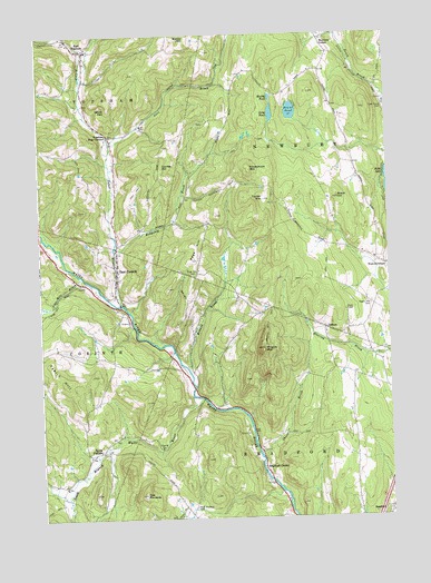
East Corinth, VT USGS Topographic Map
Click on map above to begin viewing in our Map Viewer.

This topographic map contains these locations and features:
Feature Name Type Latitude Longitude GNIS ID View Map
Avery Family CemeteryCemeteryN44.1108°W72.2457°1921313View Map
Blake Memorial LibraryBuildingN44.0673°W72.2226°1921324View Map
Bradford CenterPopulated PlaceN44.0131°W72.1706°1456539View Map
Brock HillSummitN44.0826°W72.1426°1456578View Map
Brock Hill School (historical)SchoolN44.0962°W72.1384°1921338View Map
Chase BrookStreamN44.0167°W72.1729°1456855View Map
Currier HillSummitN44.0915°W72.2054°1457072View Map
Currier Hill CemeteryCemeteryN44.0961°W72.2049°1921377View Map
Devils DenBasinN44.1059°W72.2251°1457158View Map
East CorinthPopulated PlaceN44.0640°W72.2223°1457271View Map
East Corinth New CemeteryCemeteryN44.0590°W72.2245°1921391View Map
East Corinth Old CemeteryCemeteryN44.0606°W72.2214°1921390View Map
East Corinth Post OfficePost OfficeN44.0647°W72.2222°1921392View Map
East Corinth Volunteer Fire DepartmentBuildingN44.0659°W72.2218°2121318View Map
East TopshamPopulated PlaceN44.1212°W72.2329°1457326View Map
East Topsham CemeteryCemeteryN44.1188°W72.2324°1921400View Map
GoshenPopulated PlaceN44.0492°W72.1481°1457581View Map
Goshen CemeteryCemeteryN44.0402°W72.1469°1921422View Map
Goshen ChurchChurchN44.0478°W72.1479°1921423View Map
Goshen School (historical)SchoolN44.0028°W72.1379°1921424View Map
Halls LakeReservoirN44.0801°W72.1295°1766454View Map
Halls Lake DamDamN44.0801°W72.1295°1766453View Map
Hedgehog BrookStreamN44.0681°W72.2231°1457790View Map
Iras PinnaclePillarN44.0065°W72.2137°1457971View Map
Levi BrookStreamN44.0973°W72.2243°1458196View Map
Long PondLakeN44.1043°W72.1661°1458277View Map
Meadow BrookStreamN44.0392°W72.1979°1458408View Map
Mills Family CemeteryCemeteryN44.1236°W72.2028°1921484View Map
Muddy PondLakeN44.1088°W72.1663°1458637View Map
Munn-Rowell CemeteryCemeteryN44.0033°W72.2304°1921496View Map
Newbury CenterPopulated PlaceN44.1237°W72.1484°1460440View Map
Page HillSummitN44.0673°W72.1945°1458878View Map
Page Hill CemeteryCemeteryN44.0629°W72.1952°1458879View Map
Pike Hill BrookStreamN44.0634°W72.2343°1458966View Map
Renfrow - Heath CemeteryCemeteryN44.1020°W72.1904°1921533View Map
Rogers Hill CemeteryCemeteryN44.0549°W72.1315°1459242View Map
Round PondLakeN44.1051°W72.1589°1459258View Map
South Branch Waits RiverStreamN44.0317°W72.1962°1459573View Map
South CorinthPopulated PlaceN44.0162°W72.2326°1459581View Map
South Corinth School (historical)SchoolN44.0165°W72.2312°1921551View Map
Tabor BranchStreamN44.0567°W72.2212°1459808View Map
Taplin HillSummitN44.0409°W72.2468°1459822View Map
Taplin Hill School (historical)SchoolN44.0415°W72.2306°1921573View Map
Topsham Four CornersPopulated PlaceN44.0990°W72.2245°1459928View Map
Town House CemeteryCemeteryN44.1061°W72.1254°1459938View Map
Town of BradfordCivilN44.0110°W72.1581°1462046View Map
Tri - Village Fire DepartmentBuildingN44.1224°W72.2367°2121337View Map
Tucker MountainSummitN44.0823°W72.1693°1459960View Map
Tucker Mountain - Putnam CemeteryCemeteryN44.0709°W72.1474°1921590View Map
West Bradford CemeteryCemeteryN44.0030°W72.1957°1460114View Map
West Bradford School (historical)SchoolN44.0017°W72.1973°1921620View Map
West Newbury Village Historic DistrictParkN44.0642°W72.1254°1921637View Map
Woodchuck MountainSummitN44.0901°W72.1740°1460313View Map
Wrights MountainSummitN44.0437°W72.1704°1460332View Map
Wrights Mountain CemeteryCemeteryN44.0448°W72.1842°1921654View Map
Wrights Mountain TrailTrailN44.0501°W72.1690°1460333View Map

Note: Coordinates in the location and feature list above are referenced to NAD83 datum.


Copyright (C) 2008-2024 Ryan Niemi / Sunset Dynamics ... All Rights Reserved