TopoQuest Logo
Do you find TopoQuest useful?
Help keep TopoQuest running and adding new maps/features by donating!
Bitcoin:  19c7KJd3qBynnjoSw5npx9KScwjBe4ifkT
Litecoin:  LXs6TkuXGGXo1vDsWCkWVdjQX94eUKd6ui
Home View Maps Find Maps Find Places Resources & Links


Woodsville, New Hampshire Topographic Map

USGS Map Title: Woodsville, NH
USGS Map MRC: 44072B1
DRG (GeoTIFF) Download: o44072b1.tif


Neighboring USGS Topographic Map Quads:


  Lower Waterford, VT  
44071C8
 

  Groton, VT  
44072B2
 

  Woodsville, NH  
44072B1
 

  Lisbon, NH  
44071B8
 

  East Corinth, VT  
44072A2
 

  Newbury, VT  
44072A1
 

  East Haverhill, NH  
44071A8


Map MRC Location:

N45°
W73°
N45°
W72°
H8 H7 H6 H5 H4 H3 H2 H1
G8 G7 G6 G5 G4 G3 G2 G1
F8 F7 F6 F5 F4 F3 F2 F1
E8 E7 E6 E5 E4 E3 E2 E1
D8 D7 D6 D5 D4 D3 D2 D1
C8 C7 C6 C5 C4 C3 C2 C1
B8 B7 B6 B5 B4 B3 B2 B1
A8 A7 A6 A5 A4 A3 A2 A1
N44°
W73°
N44°
W72°

Woodsville, NH USGS 1:24K Topographic Map Preview:
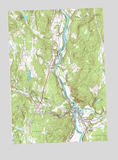
Woodsville, NH USGS Topographic Map
Click on map above to begin viewing in our Map Viewer.

This topographic map contains these locations and features:
Feature Name Type Latitude Longitude GNIS ID View Map
Ammonoosuc RiverStreamN44.1553°W72.0379°871393View Map
Ammonoosuc River ReservoirReservoirN44.1510°W72.0300°1774882View Map
Bath-Haverhill BridgeBridgeN44.1545°W72.0362°1916419View Map
Blue Mountain CemeteryCemeteryN44.2075°W72.1060°1919442View Map
Blue Mountain SchoolSchoolN44.1554°W72.0832°1456491View Map
Blue Mountain Supervisory UnionSchoolN44.1554°W72.0832°2427355View Map
BoltonvillePopulated PlaceN44.1709°W72.0998°1456517View Map
Boltonville CemeteryCemeteryN44.1577°W72.0876°1456518View Map
Burton BrookStreamN44.1548°W72.0198°865880View Map
Carbee CemeteryCemeteryN44.1724°W72.0467°865996View Map
Carbee School (historical)SchoolN44.1853°W72.0515°1916472View Map
Connecticut River ReservoirReservoirN44.2084°W72.0579°1774777View Map
Cottage HospitalHospitalN44.1353°W72.0233°866358View Map
East RyegatePopulated PlaceN44.2051°W72.0612°1457318View Map
East Ryegate Post OfficePost OfficeN44.2050°W72.0626°1919500View Map
Four CornersLocaleN44.1540°W72.0870°1457478View Map
French Pond SchoolSchoolN44.1450°W72.0344°2500267View Map
Gardner MountainRidgeN44.2181°W72.0237°867014View Map
Hamm CemeteryCemeteryN44.1881°W72.0521°867336View Map
Hunt Mountain BrookStreamN44.2426°W72.0473°867680View Map
InterchangeCrossingN44.1601°W72.0890°1461795View Map
Interchange 17CrossingN44.1598°W72.0893°1921447View Map
King Street SchoolSchoolN44.1457°W72.0357°2500273View Map
Lake GardnerLakeN44.1635°W72.0096°867016View Map
Leighton Hill School (historical)SchoolN44.1365°W72.1095°1921463View Map
Manchester BrookStreamN44.2101°W72.0601°1458342View Map
Mills Memorial CemeteryCemeteryN44.1537°W72.0541°1458480View Map
Newbury Volunteer Fire Department Wells River StationBuildingN44.1543°W72.0474°2121324View Map
No Mans IslandIslandN44.1556°W72.0393°868755View Map
Pine Grove CemeteryCemeteryN44.1381°W72.0184°869170View Map
Pleasant Valley CampgroundLocaleN44.1898°W72.1012°1919657View Map
Red SchoolSchoolN44.2476°W72.0895°1919666View Map
Ryegate CornerPopulated PlaceN44.2084°W72.1037°1459297View Map
Ryegate Fire DepartmentBuildingN44.2081°W72.1048°2121407View Map
Ryegate Paper Company DamDamN44.2084°W72.0579°1774776View Map
Saint Josephs CemeteryCemeteryN44.1806°W72.0508°869704View Map
Saint Luke Episcopal ChurchChurchN44.1503°W72.0359°1916801View Map
Scotch BurnStreamN44.1920°W72.1012°1460389View Map
Symes PondLakeN44.2442°W72.1020°1458305View Map
Tenney PondReservoirN44.1599°W72.1132°1457717View Map
Ticklenaked PondLakeN44.1882°W72.0992°1459904View Map
Town of RyegateCivilN44.2221°W72.1145°1462195View Map
Village of Wells RiverCivilN44.1537°W72.0617°2378330View Map
Wallace HillSummitN44.1331°W72.0740°1460050View Map
Warners CampgroundLocaleN44.2403°W72.0579°1919750View Map
Wells RiverPopulated PlaceN44.1542°W72.0470°1460106View Map
Wells RiverStreamN44.1523°W72.0426°1460107View Map
Wells River Historic DistrictParkN44.1531°W72.0468°1921617View Map
Wells River Post OfficePost OfficeN44.1537°W72.0472°1921618View Map
West Bath School (historical)SchoolN44.2028°W72.0079°1916892View Map
WoodsvillePopulated PlaceN44.1523°W72.0373°870998View Map
Woodsville Census Designated PlaceCensusN44.1452°W72.0287°2378099View Map
Woodsville Elementary SchoolSchoolN44.1441°W72.0244°1916921View Map
Woodsville Emergency ServicesBuildingN44.1416°W72.0241°2658860View Map
Woodsville Fire and RescueBuildingN44.1415°W72.0239°2605186View Map
Woodsville Free Public LibraryBuildingN44.1498°W72.0354°1916922View Map
Woodsville High SchoolSchoolN44.1450°W72.0360°1916923View Map
Woodsville Hydroelectric DamDamN44.1501°W72.0329°1774881View Map
Woodsville Junction (historical)LocaleN44.1417°W72.0240°1916924View Map
Woodsville Opera BuildingBuildingN44.1537°W72.0376°1916925View Map
Woodsville Post OfficePost OfficeN44.1519°W72.0376°1916926View Map
WYKR-AM (Wells River)TowerN44.1487°W72.0668°1461994View Map

Note: Coordinates in the location and feature list above are referenced to NAD83 datum.


Copyright (C) 2008-2024 Ryan Niemi / Sunset Dynamics ... All Rights Reserved