TopoQuest Logo
Do you find TopoQuest useful?
Help keep TopoQuest running and adding new maps/features by donating!
Bitcoin:  19c7KJd3qBynnjoSw5npx9KScwjBe4ifkT
Litecoin:  LXs6TkuXGGXo1vDsWCkWVdjQX94eUKd6ui
Home View Maps Find Maps Find Places Resources & Links


Newbury, Vermont Topographic Map

USGS Map Title: Newbury, VT
USGS Map MRC: 44072A1
DRG (GeoTIFF) Download: o44072a1.tif


Neighboring USGS Topographic Map Quads:


  Groton, VT  
44072B2
 

  Woodsville, NH  
44072B1
 

  Lisbon, NH  
44071B8
 

  East Corinth, VT  
44072A2
 

  Newbury, VT  
44072A1
 

  East Haverhill, NH  
44071A8
 

  Fairlee, VT  
43072H2
 

  Piermont, NH  
43072H1
 

  Warren, NH  
43071H8


Map MRC Location:

N45°
W73°
N45°
W72°
H8 H7 H6 H5 H4 H3 H2 H1
G8 G7 G6 G5 G4 G3 G2 G1
F8 F7 F6 F5 F4 F3 F2 F1
E8 E7 E6 E5 E4 E3 E2 E1
D8 D7 D6 D5 D4 D3 D2 D1
C8 C7 C6 C5 C4 C3 C2 C1
B8 B7 B6 B5 B4 B3 B2 B1
A8 A7 A6 A5 A4 A3 A2 A1
N44°
W73°
N44°
W72°

Newbury, VT USGS 1:24K Topographic Map Preview:
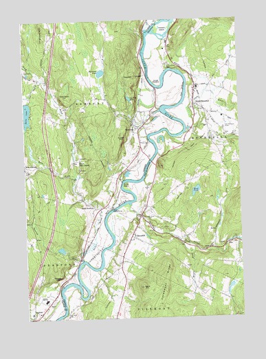
Newbury, VT USGS Topographic Map
Click on map above to begin viewing in our Map Viewer.

This topographic map contains these locations and features:
Feature Name Type Latitude Longitude GNIS ID View Map
Abbot CemeteryCemeteryN44.0820°W72.0181°1964867View Map
Ames Plaza Shopping CenterLocaleN44.0967°W72.0237°1916396View Map
Bailey EddyRapidsN44.0562°W72.0676°865327View Map
Bayley Historic DistrictParkN44.0867°W72.0512°1921317View Map
Bedell Covered BridgeBridgeN44.0456°W72.0748°1456364View Map
Bedell Covered BridgeBridgeN44.0453°W72.0748°865502View Map
Black HillSummitN44.0131°W72.0576°865625View Map
Blackmount StationLocaleN44.0873°W72.0204°1916430View Map
Bliss Tavern (historical)BuildingN44.0340°W72.0620°1916433View Map
Blodgett DamDamN44.0284°W72.1012°1766509View Map
Blodgett PondReservoirN44.0291°W72.1045°1766510View Map
Bradford Armory HeliportAirportN44.0015°W72.1226°1461916View Map
Bradford Elementary SchoolSchoolN44.0027°W72.1227°1921330View Map
Catamount RidgeRidgeN44.0170°W72.0459°866043View Map
Clark BrookStreamN44.0778°W72.0315°871686View Map
Conicut Station (historical)LocaleN44.0462°W72.0759°1921367View Map
Cow Meadow Crossing (historical)LocaleN44.1015°W72.0543°1921376View Map
Dean Memorial AirportAirportN44.0806°W72.0078°873403View Map
First Congregational ChurchChurchN44.0351°W72.0618°1916545View Map
Fish Pond DamDamN44.0920°W72.0640°1766714View Map
Grafton County OfficesBuildingN44.0965°W72.0237°1916568View Map
Grafton Sheriff DepartmentBuildingN44.1142°W72.0409°2752822View Map
Halls BrookStreamN44.0245°W72.0926°1457700View Map
Halls LakeLakeN44.0862°W72.1233°1457702View Map
Harriman BrookStreamN44.0867°W72.0454°1921432View Map
Harriman PondLakeN44.1029°W72.0795°1457739View Map
HaverhillPopulated PlaceN44.0345°W72.0640°867410View Map
Haverhill Academy (historical)SchoolN44.0345°W72.0615°1916582View Map
Haverhill Corner Fire DepartmentBuildingN44.0292°W72.0644°2605181View Map
Haverhill Corner Historic DistrictLocaleN44.0459°W72.0609°1916585View Map
Haverhill Police DepartmentBuildingN44.0960°W72.0258°2752938View Map
Haverhill Post OfficePost OfficeN44.0413°W72.0587°1916587View Map
Horse MeadowFlatN44.1001°W72.0479°867616View Map
Horse Meadow CemeteryCemeteryN44.1068°W72.0407°873186View Map
Howard IslandIslandN44.1209°W72.0456°867632View Map
Ladd Street CemeteryCemeteryN44.0440°W72.0546°867921View Map
Leighton HillSummitN44.1220°W72.1123°1458192View Map
Morris BrookStreamN44.0315°W72.0331°868568View Map
NewburyPopulated PlaceN44.0792°W72.0584°1458677View Map
Newbury Christian SchoolSchoolN44.0803°W72.0588°2427456View Map
Newbury Elementary SchoolSchoolN44.0789°W72.0600°1921472View Map
Newbury Historic DistrictParkN44.0790°W72.0581°1921473View Map
Newbury Post OfficePost OfficeN44.0794°W72.0580°1921475View Map
Newbury Volunteer Fire Department Newbury Village StationBuildingN44.0797°W72.0589°2121331View Map
Newbury Volunteer Fire Department West Newbury StationBuildingN44.0639°W72.1183°2121335View Map
North HaverhillPopulated PlaceN44.0903°W72.0265°868786View Map
North Haverhill CemeteryCemeteryN44.0820°W72.0181°1916716View Map
North Haverhill Census Designated PlaceCensusN44.0936°W72.0276°2745670View Map
North Haverhill Fire DepartmentBuildingN44.0921°W72.0254°2605203View Map
North Haverhill Post OfficePost OfficeN44.0892°W72.0259°1916717View Map
North Haverhill United Methodist ChurchChurchN44.0940°W72.0254°1916719View Map
Oliverian BrookReservoirN44.0317°W72.0079°1774880View Map
Oliverian BrookStreamN44.0476°W72.0645°872431View Map
Ox-Bow MeadowsSwampN44.0931°W72.0495°1921510View Map
Oxbow CemeteryCemeteryN44.0876°W72.0482°1458869View Map
Oxbow CemeteryCemeteryN44.0856°W72.0520°1921509View Map
Oxbow High SchoolSchoolN44.0079°W72.1138°1458870View Map
Peach BrookStreamN44.0592°W72.0956°1458914View Map
Peach Four CornersPopulated PlaceN44.0665°W72.0931°1458915View Map
Pearson Hall (historical)BuildingN44.0345°W72.0615°1916750View Map
PikePopulated PlaceN44.0309°W72.0081°869143View Map
Pike Post OfficePost OfficeN44.0309°W72.0078°1916761View Map
Pulaski MountainSummitN44.0745°W72.0687°1459101View Map
River Road CemeteryCemeteryN44.0020°W72.1016°869505View Map
Riverbend Career and Technical CenterSchoolN44.0073°W72.1145°2427466View Map
Roaring BrookStreamN44.0245°W72.0926°1459215View Map
Sawyer CemeteryCemeteryN44.0081°W72.1093°1459387View Map
Sawyer CemeteryCemeteryN44.0101°W72.1129°1921544View Map
Sawyers LedgeBenchN44.0178°W72.1056°1459392View Map
South NewburyPopulated PlaceN44.0462°W72.0848°1459599View Map
South Newbury Village Historic DistrictParkN44.0462°W72.0848°1921553View Map
Tenney Memorial LibraryBuildingN44.0801°W72.0573°1921575View Map
The Fish PondReservoirN44.0921°W72.0632°1459852View Map
The OxbowBendN44.0949°W72.0319°870390View Map
The OxbowBendN44.0957°W72.0377°1459883View Map
Town Farm HillSummitN44.0940°W72.0979°1459935View Map
Town Farm School (historical)SchoolN44.0970°W72.1093°1921589View Map
Town of NewburyCivilN44.1096°W72.1198°1462158View Map
Trinity Church of the NazareneChurchN44.1065°W72.0412°1916863View Map
Village of NewburyCivilN44.0809°W72.0599°2378317View Map
Walker Oliverian Stream DamDamN44.0317°W72.0079°1774879View Map
West NewburyPopulated PlaceN44.0645°W72.1248°1460162View Map
West Newbury CemeteryCemeteryN44.0594°W72.1247°1921634View Map
West Newbury Congregational ChurchChurchN44.0617°W72.1240°1921635View Map
West Newbury Post OfficePost OfficeN44.0644°W72.1242°1921636View Map
Wood PondLakeN44.0532°W72.0256°870976View Map

Note: Coordinates in the location and feature list above are referenced to NAD83 datum.


Copyright (C) 2008-2024 Ryan Niemi / Sunset Dynamics ... All Rights Reserved