TopoQuest Logo
Do you find TopoQuest useful?
Help keep TopoQuest running and adding new maps/features by donating!
Bitcoin:  19c7KJd3qBynnjoSw5npx9KScwjBe4ifkT
Litecoin:  LXs6TkuXGGXo1vDsWCkWVdjQX94eUKd6ui
Home View Maps Find Maps Find Places Resources & Links


Edgar Springs, Missouri Topographic Map

USGS Map Title: Edgar Springs, MO
USGS Map MRC: 37091F7
DRG (GeoTIFF) Download: o37091f7.tif


Neighboring USGS Topographic Map Quads:


  Kaintuck Hollow, MO  
37091G8
 

  Yancy Mills, MO  
37091G7
 

  Lecoma, MO  
37091G6
 

  Flat, MO  
37091F8
 

  Edgar Springs, MO  
37091F7
 

  Anutt, MO  
37091F6
 

  Beulah, MO  
37091E8
 

  Maples, MO  
37091E7
 

  Rhyse, MO  
37091E6


Map MRC Location:

N38°
W92°
N38°
W91°
H8 H7 H6 H5 H4 H3 H2 H1
G8 G7 G6 G5 G4 G3 G2 G1
F8 F7 F6 F5 F4 F3 F2 F1
E8 E7 E6 E5 E4 E3 E2 E1
D8 D7 D6 D5 D4 D3 D2 D1
C8 C7 C6 C5 C4 C3 C2 C1
B8 B7 B6 B5 B4 B3 B2 B1
A8 A7 A6 A5 A4 A3 A2 A1
N37°
W92°
N37°
W91°

Edgar Springs, MO USGS 1:24K Topographic Map Preview:
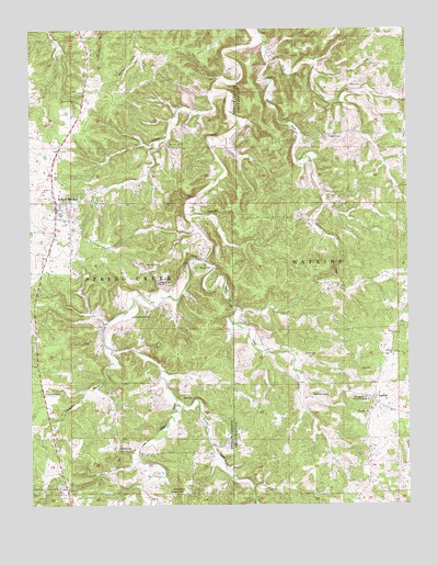
Edgar Springs, MO USGS Topographic Map
Click on map above to begin viewing in our Map Viewer.

This topographic map contains these locations and features:
Feature Name Type Latitude Longitude GNIS ID View Map
Antioch SchoolSchoolN37.6289°W91.8246°748604View Map
Bassinger Union Memorial ChapelChurchN37.6534°W91.7640°748704View Map
Bean CreekStreamN37.7414°W91.7952°748724View Map
Black CemeteryCemeteryN37.6534°W91.8215°748876View Map
Black Oak CreekStreamN37.6895°W91.8168°748886View Map
Black Oak SchoolSchoolN37.6542°W91.7768°748889View Map
Cedar Hill CemeteryCemeteryN37.6880°W91.8377°2723633View Map
Cedar Hill ChurchChurchN37.6881°W91.8371°749299View Map
Church of ChristChurchN37.7002°W91.8662°2562803View Map
City of Edgar SpringsCivilN37.7026°W91.8681°2394617View Map
CraddockPopulated PlaceN37.6395°W91.8460°749507View Map
Craddock CemeteryCemeteryN37.6395°W91.8330°2724166View Map
Edgar SpringSpringN37.7311°W91.8599°749800View Map
Edgar SpringsPopulated PlaceN37.7045°W91.8665°749801View Map
Edgar Springs CemeteryCemeteryN37.7085°W91.8672°2723838View Map
Edgar Springs Post OfficePost OfficeN37.7024°W91.8668°2782963View Map
Edgar Springs Rural Fire DepartmentBuildingN37.6980°W91.8659°2621178View Map
Enke CemeteryCemeteryN37.6603°W91.7660°749845View Map
Enon ChurchChurchN37.6489°W91.7635°749847View Map
Evening Shade ChurchChurchN37.6842°W91.8327°749871View Map
Evening Shade SchoolSchoolN37.6742°W91.8352°749873View Map
Everywhere BranchStreamN37.6659°W91.8479°749876View Map
First Baptist ChurchChurchN37.7044°W91.8661°2562783View Map
Freemans StoreLocaleN37.6539°W91.8707°749996View Map
Hall/Heavin CemeteryCemeteryN37.7414°W91.8281°2723843View Map
Horse CreekStreamN37.7412°W91.7940°750396View Map
Jackson BranchStreamN37.7370°W91.8093°750477View Map
Jocoy CemeteryCemeteryN37.7138°W91.8184°2723865View Map
Kitchen CemeteryCemeteryN37.6648°W91.7843°750629View Map
Lake TealwoodReservoirN37.6618°W91.7788°764157View Map
LenoxPopulated PlaceN37.6531°W91.7613°750685View Map
Lenox Rural Fire Department HeadquartersBuildingN37.6386°W91.7626°2621679View Map
Mitchell CemeteryCemeteryN37.6872°W91.8196°751130View Map
Mount Tabor SchoolSchoolN37.7192°W91.8282°751200View Map
North LenoxPopulated PlaceN37.6648°W91.7565°735462View Map
Old Edgar Springs CemeteryCemeteryN37.7088°W91.8672°2724026View Map
Renaud CemeteryCemeteryN37.7025°W91.8160°751851View Map
Richard F Clement Memorial State Forest and Wildlife AreaParkN37.7495°W91.7815°753964View Map
Roseberry CemeteryCemeteryN37.6281°W91.8251°751963View Map
Sample CreekStreamN37.6514°W91.8271°752021View Map
Samples CemeteryCemeteryN37.6320°W91.8081°2725634View Map
Tealwood DamDamN37.6617°W91.7802°764156View Map
Weber CemeteryCemeteryN37.7348°W91.7649°752792View Map
Weber SchoolSchoolN37.7220°W91.7754°752793View Map

Note: Coordinates in the location and feature list above are referenced to NAD83 datum.


Copyright (C) 2008-2025 Ryan Niemi / Sunset Dynamics ... All Rights Reserved