TopoQuest Logo
Do you find TopoQuest useful?
Help keep TopoQuest running and adding new maps/features by donating!
Bitcoin:  19c7KJd3qBynnjoSw5npx9KScwjBe4ifkT
Litecoin:  LXs6TkuXGGXo1vDsWCkWVdjQX94eUKd6ui
Home View Maps Find Maps Find Places Resources & Links


Yancy Mills, Missouri Topographic Map

USGS Map Title: Yancy Mills, MO
USGS Map MRC: 37091G7
DRG (GeoTIFF) Download: o37091g7.tif


Neighboring USGS Topographic Map Quads:


  Newburg, MO  
37091H8
 

  Rolla, MO  
37091H7
 

  Dillon, MO  
37091H6
 

  Kaintuck Hollow, MO  
37091G8
 

  Yancy Mills, MO  
37091G7
 

  Lecoma, MO  
37091G6
 

  Flat, MO  
37091F8
 

  Edgar Springs, MO  
37091F7
 

  Anutt, MO  
37091F6


Map MRC Location:

N38°
W92°
N38°
W91°
H8 H7 H6 H5 H4 H3 H2 H1
G8 G7 G6 G5 G4 G3 G2 G1
F8 F7 F6 F5 F4 F3 F2 F1
E8 E7 E6 E5 E4 E3 E2 E1
D8 D7 D6 D5 D4 D3 D2 D1
C8 C7 C6 C5 C4 C3 C2 C1
B8 B7 B6 B5 B4 B3 B2 B1
A8 A7 A6 A5 A4 A3 A2 A1
N37°
W92°
N37°
W91°

Yancy Mills, MO USGS 1:24K Topographic Map Preview:
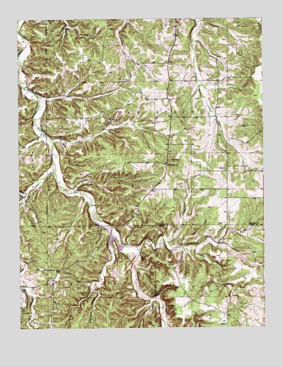
Yancy Mills, MO USGS Topographic Map
Click on map above to begin viewing in our Map Viewer.

This topographic map contains these locations and features:
Feature Name Type Latitude Longitude GNIS ID View Map
Allen CemeteryCemeteryN37.8258°W91.8696°2571463View Map
Allison and Haas Lake DamDamN37.7900°W91.7685°765305View Map
Ben Fore SchoolSchoolN37.8442°W91.8554°741517View Map
Blossom Rock TrailTrailN37.7953°W91.8324°754087View Map
Brookshire CemeteryCemeteryN37.7570°W91.8729°749034View Map
Carmack HollowValleyN37.7828°W91.7854°749215View Map
Cedar Bluff TrailTrailN37.8031°W91.8379°754089View Map
Church of GodChurchN37.7773°W91.8385°749353View Map
Coalpit HollowValleyN37.8248°W91.8535°749393View Map
Corn CreekStreamN37.8131°W91.8579°749477View Map
Corn Creek CemeteryCemeteryN37.8034°W91.8743°749478View Map
Cross School (historical)SchoolN37.7703°W91.7790°753173View Map
Finn BranchStreamN37.7817°W91.8146°749922View Map
George Lane CemeteryCemeteryN37.7985°W91.8501°2724158View Map
Gourd CreekStreamN37.8264°W91.8582°750093View Map
Grayson SchoolSchoolN37.8559°W91.8046°741516View Map
Green Bush School (historical)SchoolN37.8570°W91.7682°741515View Map
Hines BranchStreamN37.8045°W91.8707°750339View Map
Huskey CemeteryCemeteryN37.8334°W91.8313°750434View Map
Jackson CemeteryCemeteryN37.7775°W91.8707°750482View Map
King CemeteryCemeteryN37.8120°W91.8583°2723866View Map
Kitchens BranchStreamN37.7875°W91.8282°750630View Map
Lane SpringSpringN37.7999°W91.8382°750651View Map
Lane Spring CampgroundLocaleN37.7964°W91.8368°754373View Map
Miller CemeteryCemeteryN37.7581°W91.8060°751091View Map
Moselle MineMineN37.8345°W91.8290°751163View Map
Mount Zion Baptist ChurchChurchN37.8498°W91.8207°751206View Map
Mount Zion CemeteryCemeteryN37.8499°W91.8201°2724024View Map
Old Philadelphia Baptist Church/Fore CemeteryCemeteryN37.7827°W91.8587°2724027View Map
Paddy BranchStreamN37.7662°W91.8740°751471View Map
Pecks CemeteryCemeteryN37.8628°W91.7951°2724029View Map
Perry BranchStreamN37.7831°W91.7857°751550View Map
Peter BranchStreamN37.8056°W91.8465°751562View Map
Philadelphia ChurchChurchN37.7737°W91.8568°751571View Map
Pilot KnobSummitN37.8173°W91.7982°751592View Map
Pilot Knob CemeteryCemeteryN37.8154°W91.8003°2724030View Map
Pilot Knob ChurchChurchN37.8159°W91.8010°751595View Map
Pilot Knob Lookout TowerTowerN37.8173°W91.7968°754088View Map
Piney SpringSpringN37.7782°W91.8133°751639View Map
Rhea CemeteryCemeteryN37.8137°W91.7707°2724043View Map
Rhea ChurchChurchN37.8134°W91.7702°751859View Map
Rhea SchoolSchoolN37.8134°W91.7821°753172View Map
Riley BranchStreamN37.7828°W91.7927°751877View Map
Rolla Rural Fire Protection Association SouthBuildingN37.8207°W91.7996°2620811View Map
Silver Fox Farm (historical)LocaleN37.8339°W91.8046°753815View Map
Solomon HollowValleyN37.7656°W91.8382°752246View Map
Teeters Lake DamDamN37.7650°W91.7818°765304View Map
VidaPopulated PlaceN37.8570°W91.7996°752714View Map
Williams CreekStreamN37.7853°W91.8018°752914View Map
Wright Slave CemeteryCemeteryN37.7853°W91.8309°2724049View Map
Yancy MillsPopulated PlaceN37.7912°W91.8340°752993View Map
Yancy Mills Post OfficePost OfficeN37.7967°W91.8149°759397View Map
Yancy Mills Post Office (historical)Post OfficeN37.8056°W91.8079°759566View Map
Yancy School (historical)SchoolN37.7823°W91.8299°741514View Map
Yancy SpringSpringN37.7921°W91.8347°753816View Map

Note: Coordinates in the location and feature list above are referenced to NAD83 datum.


Copyright (C) 2008-2025 Ryan Niemi / Sunset Dynamics ... All Rights Reserved