TopoQuest Logo
Do you find TopoQuest useful?
Help keep TopoQuest running and adding new maps/features by donating!
Bitcoin:  19c7KJd3qBynnjoSw5npx9KScwjBe4ifkT
Litecoin:  LXs6TkuXGGXo1vDsWCkWVdjQX94eUKd6ui
Home View Maps Find Maps Find Places Resources & Links


Edisto Island, South Carolina Topographic Map

USGS Map Title: Edisto Island, SC
USGS Map MRC: 32080E3
DRG (GeoTIFF) Download: o32080e3.tif


Neighboring USGS Topographic Map Quads:


  Fenwick, SC  
32080F4
 

  Adams Run, SC  
32080F3
 

  Wadmalaw Island, SC  
32080F2
 

  Bennetts Point, SC  
32080E4
 

  Edisto Island, SC  
32080E3
 

  Rockville, SC  
32080E2
 

  Saint Helena Sound, SC  
32080D4
 

  Edisto Beach, SC  
32080D3


Map MRC Location:

N33°
W81°
N33°
W80°
H8 H7 H6 H5 H4 H3 H2 H1
G8 G7 G6 G5 G4 G3 G2 G1
F8 F7 F6 F5 F4 F3 F2 F1
E8 E7 E6 E5 E4 E3 E2 E1
D8 D7 D6 D5 D4 D3 D2 D1
C8 C7 C6 C5 C4 C3 C2 C1
B8 B7 B6 B5 B4 B3 B2 B1
A8 A7 A6 A5 A4 A3 A2 A1
N32°
W81°
N32°
W80°

Edisto Island, SC USGS 1:24K Topographic Map Preview:
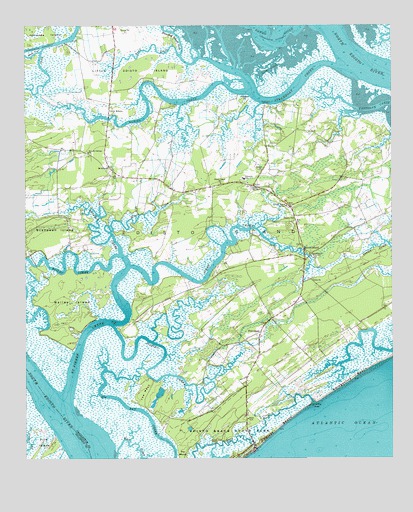
Edisto Island, SC USGS Topographic Map
Click on map above to begin viewing in our Map Viewer.

This topographic map contains these locations and features:
Feature Name Type Latitude Longitude GNIS ID View Map
Allen ChurchChurchN32.5519°W80.2770°1220163View Map
Ashley ChurchChurchN32.5727°W80.2843°1220252View Map
Bailey CreekStreamN32.5588°W80.3429°1220291View Map
Bailey IslandIslandN32.5455°W80.3582°1220293View Map
Bethel Church (historical)ChurchN32.5413°W80.2901°1252684View Map
Bethlehem ChurchChurchN32.5591°W80.2776°1220599View Map
Borough School (historical)SchoolN32.5882°W80.3537°1252694View Map
Brookland PlantationLocaleN32.5721°W80.3554°1252702View Map
Charleston County Sheriff's OfficeBuildingN32.5703°W80.2817°2334803View Map
Colleton County Fire DepartmentBuildingN32.5211°W80.2987°2368422View Map
Dodge PlantationLocaleN32.6018°W80.2818°1252809View Map
Edings IslandIslandN32.5013°W80.3029°1252819View Map
Edingsville BeachBeachN32.5235°W80.2637°1222233View Map
Edisto Beach Elementary SchoolSchoolN32.5205°W80.2983°2486440View Map
Edisto Beach State ParkParkN32.5057°W80.3112°1222235View Map
Edisto ChurchChurchN32.5791°W80.2968°1252612View Map
Edisto IslandPopulated PlaceN32.5602°W80.2798°1231262View Map
Edisto IslandIslandN32.5594°W80.2951°1247638View Map
Edisto Island ChurchChurchN32.5799°W80.3084°1252613View Map
Edisto Island DivisionCivilN32.5701°W80.3053°1938256View Map
Edisto Island LibraryBuildingN32.5730°W80.2859°1222238View Map
Edisto Island SchoolSchoolN32.5730°W80.2859°1252820View Map
Edisto Island Summary CourtBuildingN32.5706°W80.2814°2490444View Map
Fishing CreekStreamN32.5385°W80.3454°1222407View Map
FreedmanPopulated PlaceN32.5366°W80.2948°1231297View Map
Galilee ChurchChurchN32.5835°W80.2940°1222625View Map
Greater Calvary ChurchChurchN32.5885°W80.3532°1222857View Map
Jane Edwards Elementary SchoolSchoolN32.5808°W80.3000°1222245View Map
Jeremy InletGutN32.5163°W80.2770°1223547View Map
Larimer High School (historical)SchoolN32.5760°W80.2890°1252972View Map
Little EdistoPopulated PlaceN32.5999°W80.3445°1231484View Map
Little Edisto IslandIslandN32.6149°W80.3429°1223989View Map
Long CreekStreamN32.6071°W80.2957°1224163View Map
Milton CreekStreamN32.5649°W80.3454°1224587View Map
Mount Holly Church (historical)ChurchN32.5921°W80.3720°1253030View Map
Mount Olive ChurchChurchN32.5844°W80.3465°1224742View Map
Mud CreekStreamN32.5013°W80.3440°1224869View Map
Peters PointCapeN32.5382°W80.3440°1225391View Map
Peters Point PlantationLocaleN32.5374°W80.3423°1253111View Map
Rabbits PointCapeN32.6043°W80.2995°1225730View Map
Russel CreekStreamN32.6066°W80.2979°1226078View Map
Saint Paul's Fire Department Edisto IslandBuildingN32.5770°W80.2923°2368145View Map
Saint Pierre CreekStreamN32.5169°W80.3615°1226268View Map
Sand CreekStreamN32.6066°W80.2979°1226322View Map
Scanawah IslandIslandN32.5652°W80.3654°1226436View Map
Scott CreekStreamN32.5163°W80.2770°1226457View Map
Sea Side School (historical)SchoolN32.5357°W80.2979°1253228View Map
Shingle CreekStreamN32.5557°W80.3398°1226581View Map
Steamboat CreekStreamN32.6130°W80.2679°1226875View Map
Steamboat LandingPopulated PlaceN32.6021°W80.2929°1231827View Map
Store CreekStreamN32.5557°W80.3393°1226919View Map
The Edisto Island MuseumBuildingN32.5762°W80.3200°2490424View Map
The MoundSummitN32.5019°W80.3218°1231859View Map
The NeckCapeN32.5196°W80.3334°1227082View Map
Trinity CemeteryCemeteryN32.5699°W80.2834°1253292View Map
Trinity ChurchChurchN32.5694°W80.2834°1227203View Map
Whooping Island CreekStreamN32.6166°W80.3212°1227584View Map
Zion ChurchChurchN32.5680°W80.2820°1227747View Map

Note: Coordinates in the location and feature list above are referenced to NAD83 datum.


Copyright (C) 2008-2025 Ryan Niemi / Sunset Dynamics ... All Rights Reserved