TopoQuest Logo
Do you find TopoQuest useful?
Help keep TopoQuest running and adding new maps/features by donating!
Bitcoin:  19c7KJd3qBynnjoSw5npx9KScwjBe4ifkT
Litecoin:  LXs6TkuXGGXo1vDsWCkWVdjQX94eUKd6ui
Home View Maps Find Maps Find Places Resources & Links


Bennetts Point, South Carolina Topographic Map

USGS Map Title: Bennetts Point, SC
USGS Map MRC: 32080E4
DRG (GeoTIFF) Download: o32080e4.tif


Neighboring USGS Topographic Map Quads:


  Green Pond, SC  
32080F5
 

  Fenwick, SC  
32080F4
 

  Adams Run, SC  
32080F3
 

  Wiggins, SC  
32080E5
 

  Bennetts Point, SC  
32080E4
 

  Edisto Island, SC  
32080E3
 

  Frogmore, SC  
32080D5
 

  Saint Helena Sound, SC  
32080D4
 

  Edisto Beach, SC  
32080D3


Map MRC Location:

N33°
W81°
N33°
W80°
H8 H7 H6 H5 H4 H3 H2 H1
G8 G7 G6 G5 G4 G3 G2 G1
F8 F7 F6 F5 F4 F3 F2 F1
E8 E7 E6 E5 E4 E3 E2 E1
D8 D7 D6 D5 D4 D3 D2 D1
C8 C7 C6 C5 C4 C3 C2 C1
B8 B7 B6 B5 B4 B3 B2 B1
A8 A7 A6 A5 A4 A3 A2 A1
N32°
W81°
N32°
W80°

Bennetts Point, SC USGS 1:24K Topographic Map Preview:
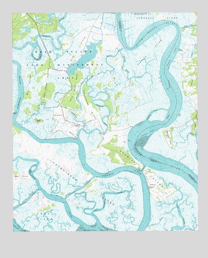
Bennetts Point, SC USGS Topographic Map
Click on map above to begin viewing in our Map Viewer.

This topographic map contains these locations and features:
Feature Name Type Latitude Longitude GNIS ID View Map
Alligator CreekStreamN32.5624°W80.4098°1220178View Map
Ashe IslandIslandN32.5082°W80.4798°1220248View Map
Ashepoo Coosaw CutoffChannelN32.5196°W80.4720°1220249View Map
Bank CreekStreamN32.5005°W80.4312°1220313View Map
Bear IslandIslandN32.6119°W80.4451°1220406View Map
Bear Island Game Management AreaParkN32.5994°W80.4676°1220408View Map
Beet IslandIslandN32.5302°W80.4973°1220471View Map
Bennetts PointCapeN32.5549°W80.4582°1246741View Map
Bennetts PointPopulated PlaceN32.5610°W80.4545°1246742View Map
Bennetts Point SchoolSchoolN32.5666°W80.4657°1220499View Map
Bluff IslandsIslandN32.5805°W80.4882°1220829View Map
Bull CutChannelN32.5913°W80.4395°1247053View Map
Colleton County Fire Rescue Bennett's Point Fire StationBuildingN32.5611°W80.4546°2368419View Map
Crooked CreekStreamN32.5613°W80.4948°1221833View Map
Dodge PlantationLocaleN32.5552°W80.4384°1240609View Map
Fenwick CutChannelN32.5357°W80.4118°1222376View Map
Fenwick IslandIslandN32.5382°W80.4162°1247735View Map
Green Pond DivisionCivilN32.6157°W80.4746°1938284View Map
Hole-in-the-WallBendN32.5988°W80.4829°1223221View Map
Hutchinson IslandIslandN32.5285°W80.4554°1246106View Map
Long Ashepoo CreekStreamN32.5027°W80.4145°1224108View Map
Mosquito CreekStreamN32.5524°W80.4551°1249534View Map
Musselboro CreekStreamN32.5574°W80.4476°1224907View Map
Musselboro IslandIslandN32.5732°W80.4490°1249767View Map
Pine LandingPopulated PlaceN32.6030°W80.3873°1231657View Map
Raccoon IslandIslandN32.5530°W80.3943°1225732View Map
Rock CreekStreamN32.5024°W80.4509°1250412View Map
Samaritan ChurchChurchN32.5249°W80.4082°1226303View Map
Sampson IslandIslandN32.6021°W80.4070°1226310View Map
Sampson Island CreekStreamN32.6035°W80.4265°1226312View Map
Sawyers IslandIslandN32.5635°W80.4826°1250805View Map
SeabrookPopulated PlaceN32.5263°W80.4073°1231784View Map
Seabrook School (historical)SchoolN32.5274°W80.4087°1240738View Map
Settlement IslandsIslandN32.5846°W80.4757°1226503View Map
Two Sisters CreekStreamN32.5035°W80.4423°1227181View Map
Watts CutChannelN32.6171°W80.3790°1227444View Map
White House WoodsWoodsN32.5807°W80.4590°1227536View Map

Note: Coordinates in the location and feature list above are referenced to NAD83 datum.


Copyright (C) 2008-2025 Ryan Niemi / Sunset Dynamics ... All Rights Reserved