TopoQuest Logo
Do you find TopoQuest useful?
Help keep TopoQuest running and adding new maps/features by donating!
Bitcoin:  19c7KJd3qBynnjoSw5npx9KScwjBe4ifkT
Litecoin:  LXs6TkuXGGXo1vDsWCkWVdjQX94eUKd6ui
Home View Maps Find Maps Find Places Resources & Links


Egnar, Colorado Topographic Map

USGS Map Title: Egnar, CO
USGS Map MRC: 37108H8
DRG (GeoTIFF) Download: o37108h8.tif


Neighboring USGS Topographic Map Quads:


  Summit Point, UT  
38109A1
 

  Horse Range Mesa, CO  
38108A8
 

  Hamm Canyon, CO  
38108A7
 

  Piute Knoll, UT  
37109H1
 

  Egnar, CO  
37108H8
 

  Joe Davis Hill, CO  
37108H7
 

  Northdale, CO  
37109G1
 

  Dove Creek, CO  
37108G8
 

  Secret Canyon, CO  
37108G7


Map MRC Location:

N38°
W109°
N38°
W108°
H8 H7 H6 H5 H4 H3 H2 H1
G8 G7 G6 G5 G4 G3 G2 G1
F8 F7 F6 F5 F4 F3 F2 F1
E8 E7 E6 E5 E4 E3 E2 E1
D8 D7 D6 D5 D4 D3 D2 D1
C8 C7 C6 C5 C4 C3 C2 C1
B8 B7 B6 B5 B4 B3 B2 B1
A8 A7 A6 A5 A4 A3 A2 A1
N37°
W109°
N37°
W108°

Egnar, CO USGS 1:24K Topographic Map Preview:
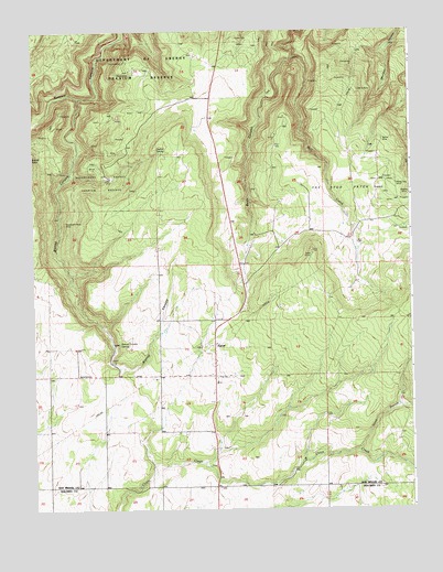
Egnar, CO USGS Topographic Map
Click on map above to begin viewing in our Map Viewer.

This topographic map contains these locations and features:
Feature Name Type Latitude Longitude GNIS ID View Map
Allison Drilling Company MineMineN37.9161°W108.9404°1734140View Map
Ann Number One MineMineN37.9903°W108.9607°1734141View Map
Ann Number Two MineMineN37.9917°W108.9651°1734142View Map
Barkley Lease MineMineN37.9189°W108.9404°1734143View Map
Bell CreekStreamN37.9930°W108.9132°176289View Map
Bessie MineMineN37.9717°W108.8820°176288View Map
Big Chief MineMineN37.9608°W108.8779°1734174View Map
Bishop CanyonValleyN37.9828°W108.9843°176283View Map
Bishop Canyon MineMineN37.9411°W108.9865°1734144View Map
Bishop Canyon SpringSpringN37.9189°W108.9729°176281View Map
Black Jack MineMineN37.9608°W108.9715°1734102View Map
Boondock Number One MineMineN37.9178°W108.9404°1734145View Map
Charles P MineMineN37.9178°W108.9404°1734147View Map
Chief One MineMineN37.9761°W108.9707°1734103View Map
Cowgirl Number Two MineMineN37.9636°W108.9798°1734148View Map
Dorothy Mae MineMineN37.9189°W108.9415°1734149View Map
Easton B MineMineN37.9189°W108.9415°1734150View Map
Effie B. MineMineN37.9853°W108.8929°176287View Map
EgnarPopulated PlaceN37.9164°W108.9401°176280View Map
Egnar - Slick Rock Fire DepartmentBuildingN37.9098°W108.9392°2667311View Map
Egnar Post OfficePost OfficeN37.9031°W108.9409°2759192View Map
Egnar SchoolSchoolN37.9097°W108.9401°176279View Map
Falcon MineMineN37.9680°W108.9743°1734100View Map
Frankie MineMineN37.9911°W108.9707°176294View Map
Frenchie Point MineMineN37.9672°W108.9829°1734151View Map
Frenchie Rim MineMineN37.9675°W108.9798°1734152View Map
Frenchy Two MineMineN37.9661°W108.9801°1734107View Map
Fritz-Erickson MineMineN37.9611°W108.9859°1734153View Map
Full Moon Number Two MineMineN37.9189°W108.9404°1734154View Map
Goforth Homestead MineMineN37.9928°W108.9509°1734104View Map
Golden Rod MinesMineN37.9964°W108.9309°176290View Map
Goldenrod Number Five MineMineN37.9972°W108.9315°1734155View Map
Governor MineMineN37.9592°W108.9859°1734105View Map
Hangover MineMineN37.9742°W108.9684°1734109View Map
Hawk MineMineN37.9886°W108.9693°176295View Map
Hawk-Frankie MineMineN37.9886°W108.9682°1734110View Map
Independence MineMineN37.9889°W108.9884°1734111View Map
J. B. Crawley MinesMineN37.9189°W108.9415°1734156View Map
Joe Bush Group MineMineN37.9592°W108.9312°1734112View Map
Jupiter MineMineN37.9464°W108.8759°1734113View Map
Katie MineMineN37.9742°W108.9137°1734114View Map
Keystone MineMineN37.9869°W108.9293°1734115View Map
King MineMineN37.9658°W108.9829°1734157View Map
Latricia MineMineN37.9764°W108.9865°1734116View Map
Legin MinesMineN37.9650°W108.9809°176293View Map
Little Helen MineMineN37.9911°W108.8962°1734117View Map
Little Max MineMineN37.9603°W108.8857°1734158View Map
Lone Park Number Two MineMineN37.9603°W108.8948°1734159View Map
Lone Peak MineMineN37.9483°W108.9862°1734118View Map
Lost Dog MineMineN37.9994°W108.9668°1734119View Map
Lucky Day MineMineN37.9758°W108.9126°1734120View Map
Lucky J MineMineN37.9603°W108.8948°1734160View Map
Marie One MineMineN37.9583°W108.9893°1734121View Map
Marne Group MineMineN37.9483°W108.8759°1734122View Map
May Number One MineMineN37.9647°W108.9776°1734161View Map
May Number Three MineMineN37.9647°W108.9776°1734163View Map
May Number Two MineMineN37.9647°W108.9776°1734162View Map
Mayday MineMineN37.9567°W108.8773°176285View Map
McCormick Shaft MineMineN37.9611°W108.9859°1734164View Map
Mercantile Bright MineMineN37.9925°W108.9873°1734123View Map
Michael Bray MineMineN37.9892°W108.9596°1734165View Map
Mickey MineMineN37.9178°W108.9404°1734166View Map
Mickey Three MineMineN37.9772°W108.9876°1734124View Map
Montezuma MineMineN37.9739°W108.8957°1734125View Map
Moqui Jug MineMineN37.9597°W108.8793°176286View Map
Mucha Grande MineMineN37.9522°W108.8940°1745408View Map
Nelson and Larson MineMineN37.9161°W108.9404°1734167View Map
Norma Jean Number Two MineMineN37.9600°W108.8779°1734126View Map
North Branch Chico CreekStreamN37.8905°W108.8934°176275View Map
O'Neill Group MinesMineN37.9161°W108.9415°1734169View Map
Ocumpaugh MineMineN37.9522°W108.8940°1745409View Map
Oliver Vanadium MineMineN37.9319°W108.9218°1734168View Map
Ortmayer Lease MineMineN37.9522°W108.8940°1745410View Map
Overall SpringSpringN37.9682°W108.9575°176291View Map
Owenby Group MineMineN37.9522°W108.8940°1734170View Map
Paper Ore Body MineMineN37.9522°W108.8940°1745413View Map
Pay Lode Numbers One-Five MinesMineN37.9319°W108.9673°1734171View Map
Paystreak Number Three MineMineN37.9622°W108.8948°1734128View Map
Penigal MineMineN37.9742°W108.9173°1734129View Map
Pine Bug MineMineN37.9600°W108.9848°1734130View Map
Queen of Spades MineMineN37.9919°W108.8940°1734131View Map
Rattlesnake MineMineN37.9783°W108.9790°1734132View Map
Roger Number One MineMineN37.9522°W108.8940°1745427View Map
Sam MineMineN37.9644°W108.9776°1734172View Map
Santa Maria MineMineN37.9897°W108.9337°1734133View Map
Schlee MineMineN37.9600°W108.9301°1734134View Map
Sibley MineMineN37.9744°W108.8773°1734135View Map
Star MineMineN37.9611°W108.8937°1734137View Map
Strawberry Roan MineMineN37.9411°W108.9921°176282View Map
Strawberry Roan MineMineN37.9500°W108.9898°176296View Map
Summit MineMineN37.9939°W108.9323°1734101View Map
Teton Exploration MineMineN37.9161°W108.9404°1734173View Map
The Spud PatchFlatN37.9586°W108.8984°176284View Map
Uintah MineMineN37.9603°W108.9762°176292View Map
Uintah Two LodeMineN37.9600°W108.9779°1734138View Map
Victor Number Three MineMineN37.9161°W108.9404°1734146View Map
Victor Two MineMineN37.9755°W108.9854°1734139View Map
Wilson MineMineN37.9522°W108.8940°1745440View Map

Note: Coordinates in the location and feature list above are referenced to NAD83 datum.


Copyright (C) 2008-2024 Ryan Niemi / Sunset Dynamics ... All Rights Reserved