TopoQuest Logo
Do you find TopoQuest useful?
Help keep TopoQuest running and adding new maps/features by donating!
Bitcoin:  19c7KJd3qBynnjoSw5npx9KScwjBe4ifkT
Litecoin:  LXs6TkuXGGXo1vDsWCkWVdjQX94eUKd6ui
Home View Maps Find Maps Find Places Resources & Links


Joe Davis Hill, Colorado Topographic Map

USGS Map Title: Joe Davis Hill, CO
USGS Map MRC: 37108H7
DRG (GeoTIFF) Download: o37108h7.tif


Neighboring USGS Topographic Map Quads:


  Horse Range Mesa, CO  
38108A8
 

  Hamm Canyon, CO  
38108A7
 

  Gypsum Gap, CO  
38108A6
 

  Egnar, CO  
37108H8
 

  Joe Davis Hill, CO  
37108H7
 

  Dawson Draw, CO  
37108H6
 

  Dove Creek, CO  
37108G8
 

  Secret Canyon, CO  
37108G7
 

  The Glade, CO  
37108G6


Map MRC Location:

N38°
W109°
N38°
W108°
H8 H7 H6 H5 H4 H3 H2 H1
G8 G7 G6 G5 G4 G3 G2 G1
F8 F7 F6 F5 F4 F3 F2 F1
E8 E7 E6 E5 E4 E3 E2 E1
D8 D7 D6 D5 D4 D3 D2 D1
C8 C7 C6 C5 C4 C3 C2 C1
B8 B7 B6 B5 B4 B3 B2 B1
A8 A7 A6 A5 A4 A3 A2 A1
N37°
W109°
N37°
W108°

Joe Davis Hill, CO USGS 1:24K Topographic Map Preview:
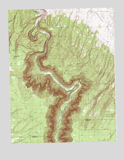
Joe Davis Hill, CO USGS Topographic Map
Click on map above to begin viewing in our Map Viewer.

This topographic map contains these locations and features:
Feature Name Type Latitude Longitude GNIS ID View Map
Bell CanyonValleyN37.9446°W108.8408°176304View Map
Bell Canyon ReservoirReservoirN37.9178°W108.8577°176309View Map
Betty Ruth MineMineN37.9519°W108.8659°1735874View Map
Buckhorn MineMineN37.9317°W108.8384°1734175View Map
Clear View ClaimsMineN37.9330°W108.7876°1734176View Map
Curtis MineMineN37.9605°W108.8595°1734177View Map
Dan MineMineN37.9317°W108.8045°1734194View Map
Depression MineMineN37.9572°W108.8687°1734195View Map
Dolores River MineMineN37.9397°W108.8057°1734178View Map
DR ReservoirReservoirN37.8820°W108.7961°197180View Map
Egnar HeliportAirportN37.8830°W108.8345°204375View Map
Fox MineMineN37.9608°W108.8243°1734179View Map
France MineMineN37.9733°W108.8718°1734106View Map
Full Moon Group MineMineN37.9900°W108.8393°1735440View Map
Full Moon MineMineN37.9892°W108.8404°1734196View Map
Horseshoe One through Seven MinesMineN37.9286°W108.7815°1734180View Map
Joe Davis HillSummitN37.9492°W108.8276°176301View Map
Joe Davis Hill MineMineN37.9380°W108.8159°1735493View Map
Little Max MineMineN37.9589°W108.8595°1734181View Map
Little Pony ReservoirReservoirN37.8842°W108.7796°197181View Map
Little Roy MineMineN37.9605°W108.8595°1734182View Map
Mardi MineMineN37.9572°W108.8720°1734198View Map
Marne MineMineN37.9480°W108.8570°1734199View Map
Mucho Grande MineMineN37.9355°W108.7982°176303View Map
Muleshoe Six MineMineN37.9764°W108.8409°1734183View Map
Mystery MineMineN37.9636°W108.8218°1734184View Map
Norma Jean MineMineN37.9628°W108.8665°176298View Map
Norma Jean Number 2 MineMineN37.9617°W108.8679°176297View Map
North ReservoirReservoirN37.9155°W108.8476°197176View Map
Owensby MineMineN37.9922°W108.8587°1734127View Map
Park ReservoirReservoirN37.9050°W108.8379°197177View Map
Parrot Group MineMineN37.9625°W108.8207°1734185View Map
Parrot MineMineN37.9928°W108.8484°1734200View Map
Philura Group MineMineN37.9928°W108.8484°1745457View Map
Piney SpringSpringN37.9058°W108.8676°176306View Map
Pole Canyon ReservoirReservoirN37.8775°W108.7579°197172View Map
Pony ReservoirReservoirN37.8771°W108.7735°176311View Map
Powder Drift MineMineN37.9928°W108.8484°1734201View Map
Quakie SpringSpringN37.9200°W108.8429°176305View Map
Red Rock Four and Five MinesMineN37.9464°W108.8223°1734186View Map
Red Rock MineMineN37.9928°W108.8484°1734202View Map
Red Top MineMineN37.9322°W108.7898°1734187View Map
Rim MineMineN37.9308°W108.8034°1734188View Map
Rogers-Dalton ReservoirReservoirN37.9158°W108.8646°197183View Map
Roy Lee MineMineN37.9467°W108.8429°1735873View Map
S.B. Group MineMineN37.9175°W108.8220°1734189View Map
Sand Rock ReservoirReservoirN37.8849°W108.8425°176310View Map
Sara M. MineMineN37.9589°W108.8220°1734190View Map
Sarah Ellen MineMineN37.9642°W108.8265°176300View Map
Sawmill SpringSpringN37.9000°W108.8492°176307View Map
South Branch Chico CreekStreamN37.8855°W108.8723°176312View Map
Space Ship Number One MineMineN37.9400°W108.8134°1734203View Map
Spud Patch CampLocaleN37.9564°W108.8695°176299View Map
Spud Patch MineMineN37.9636°W108.8743°1734136View Map
Suncup MineMineN37.9467°W108.7907°1734191View Map
Suncup Two MineMineN37.9458°W108.7848°1734192View Map
Uncle Sam MineMineN37.9378°W108.7898°176302View Map
Uncle Sammy MineMineN37.9375°W108.7901°1734204View Map
Wally MineMineN37.9747°W108.8376°1734193View Map
Wayne Rogers Reservoir Number OneReservoirN37.9067°W108.8452°197184View Map
Wayne Rogers Reservoir Number TwoReservoirN37.8919°W108.8429°197178View Map
Wilson ReservoirReservoirN37.9159°W108.8735°176308View Map

Note: Coordinates in the location and feature list above are referenced to NAD83 datum.


Copyright (C) 2008-2025 Ryan Niemi / Sunset Dynamics ... All Rights Reserved