TopoQuest Logo
Do you find TopoQuest useful?
Help keep TopoQuest running and adding new maps/features by donating!
Bitcoin:  19c7KJd3qBynnjoSw5npx9KScwjBe4ifkT
Litecoin:  LXs6TkuXGGXo1vDsWCkWVdjQX94eUKd6ui
Home View Maps Find Maps Find Places Resources & Links


Elderville, Texas Topographic Map

USGS Map Title: Elderville, TX
USGS Map MRC: 32094C6
DRG (GeoTIFF) Download: o32094c6.tif


Neighboring USGS Topographic Map Quads:


  Kilgore NE, TX  
32094D7
 

  Lakeport, TX  
32094D6
 

  Easton, TX  
32094D5
 

  Kilgore SE, TX  
32094C7
 

  Elderville, TX  
32094C6
 

  Tatum, TX  
32094C5
 

  Henderson, TX  
32094B7
 

  Church Hill, TX  
32094B6
 

  Fair Play, TX  
32094B5


Map MRC Location:

N33°
W95°
N33°
W94°
H8 H7 H6 H5 H4 H3 H2 H1
G8 G7 G6 G5 G4 G3 G2 G1
F8 F7 F6 F5 F4 F3 F2 F1
E8 E7 E6 E5 E4 E3 E2 E1
D8 D7 D6 D5 D4 D3 D2 D1
C8 C7 C6 C5 C4 C3 C2 C1
B8 B7 B6 B5 B4 B3 B2 B1
A8 A7 A6 A5 A4 A3 A2 A1
N32°
W95°
N32°
W94°

Elderville, TX USGS 1:24K Topographic Map Preview:
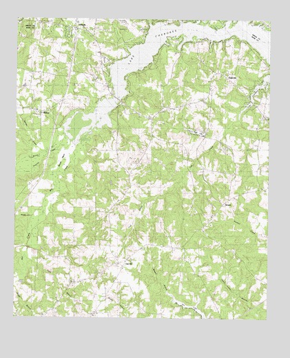
Elderville, TX USGS Topographic Map
Click on map above to begin viewing in our Map Viewer.

This topographic map contains these locations and features:
Feature Name Type Latitude Longitude GNIS ID View Map
Bacon CreekStreamN32.3207°W94.7322°1372365View Map
Barnes CreekStreamN32.3193°W94.7372°1372396View Map
Beaver MarshSwampN32.3202°W94.7238°1351734View Map
Bethel ChurchChurchN32.3043°W94.6269°1351953View Map
Boggy CreekStreamN32.2907°W94.7416°1372663View Map
Chalk HillPopulated PlaceN32.3529°W94.6510°1379527View Map
Champion Emergency Medical ServiceBuildingN32.3698°W94.7145°2655521View Map
EldervillePopulated PlaceN32.3724°W94.7285°1379709View Map
Elderville - Lakeport Volunteer Fire Department Station 1BuildingN32.3698°W94.7145°2655577View Map
Elderville - Lakeport Volunteer Fire Department Station 3BuildingN32.3531°W94.6497°2655399View Map
Freedonia ChurchChurchN32.2679°W94.6597°1357713View Map
Lake CherokeeReservoirN32.3669°W94.6656°1373068View Map
Lake Cherokee Census Designated PlaceCensusN32.3569°W94.6514°2586944View Map
Lakeview ChurchChurchN32.3477°W94.7058°1360885View Map
Lee CreekStreamN32.3502°W94.6260°1374497View Map
Long Glade LakeReservoirN32.3283°W94.6617°1361728View Map
Long Glade Lake DamDamN32.3285°W94.6552°1861237View Map
Mason LakeReservoirN32.3285°W94.6535°1863633View Map
Mason Lake LeveeDamN32.3285°W94.6535°1863632View Map
Mill CreekStreamN32.3238°W94.7202°1374944View Map
Millville ChurchChurchN32.2574°W94.7288°1362930View Map
MonroePopulated PlaceN32.3354°W94.7377°1380204View Map
Nix DamDamN32.2502°W94.6585°1861240View Map
Oak HillPopulated PlaceN32.2740°W94.6949°1380273View Map
StewartPopulated PlaceN32.2977°W94.6480°1380608View Map
Tiawichi CreekStreamN32.3265°W94.7247°1376450View Map
Todd BranchStreamN32.2738°W94.7433°1376470View Map
Waters ChapelChurchN32.2690°W94.6947°1370923View Map

Note: Coordinates in the location and feature list above are referenced to NAD83 datum.


Copyright (C) 2008-2025 Ryan Niemi / Sunset Dynamics ... All Rights Reserved