TopoQuest Logo
Do you find TopoQuest useful?
Help keep TopoQuest running and adding new maps/features by donating!
Bitcoin:  19c7KJd3qBynnjoSw5npx9KScwjBe4ifkT
Litecoin:  LXs6TkuXGGXo1vDsWCkWVdjQX94eUKd6ui
Home View Maps Find Maps Find Places Resources & Links


Fair Play, Texas Topographic Map

USGS Map Title: Fair Play, TX
USGS Map MRC: 32094B5
DRG (GeoTIFF) Download: o32094b5.tif


Neighboring USGS Topographic Map Quads:


  Elderville, TX  
32094C6
 

  Tatum, TX  
32094C5
 

  Harris Chapel, TX  
32094C4
 

  Church Hill, TX  
32094B6
 

  Fair Play, TX  
32094B5
 

  Beckville, TX  
32094B4
 

  Minden, TX  
32094A6
 

  Long Branch, TX  
32094A5
 

  Lake Murvaul, TX  
32094A4


Map MRC Location:

N33°
W95°
N33°
W94°
H8 H7 H6 H5 H4 H3 H2 H1
G8 G7 G6 G5 G4 G3 G2 G1
F8 F7 F6 F5 F4 F3 F2 F1
E8 E7 E6 E5 E4 E3 E2 E1
D8 D7 D6 D5 D4 D3 D2 D1
C8 C7 C6 C5 C4 C3 C2 C1
B8 B7 B6 B5 B4 B3 B2 B1
A8 A7 A6 A5 A4 A3 A2 A1
N32°
W95°
N32°
W94°

Fair Play, TX USGS 1:24K Topographic Map Preview:
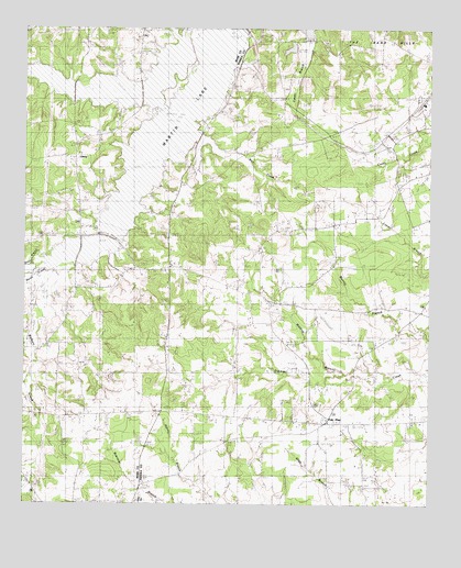
Fair Play, TX USGS Topographic Map
Click on map above to begin viewing in our Map Viewer.

This topographic map contains these locations and features:
Feature Name Type Latitude Longitude GNIS ID View Map
Beard BranchStreamN32.1890°W94.6166°1330254View Map
Brooks ChapelChurchN32.1771°W94.5510°1331318View Map
Chapel Hill ChurchChurchN32.2260°W94.6152°1332656View Map
Clayton Volunteer Fire Department Station 2BuildingN32.1462°W94.5193°2655415View Map
County Line ChurchChurchN32.1499°W94.5758°1333509View Map
Dry CreekStreamN32.2415°W94.5677°1334678View Map
Fair PlayPopulated PlaceN32.1471°W94.5313°1378279View Map
Harris CemeteryCemeteryN32.1454°W94.5299°1337384View Map
LibertyPopulated PlaceN32.2168°W94.6094°1378582View Map
Liberty CemeteryCemeteryN32.1845°W94.5968°1940471View Map
Liberty ChurchChurchN32.1690°W94.5816°1339878View Map
Liberty Missionary ChurchChurchN32.1838°W94.5963°1339892View Map
Martin LakeReservoirN32.2391°W94.5761°1861243View Map
Myers CemeteryCemeteryN32.1275°W94.5942°1342333View Map
Pine Grove ChurchChurchN32.2232°W94.5141°1344050View Map
Ross CemeteryCemeteryN32.1310°W94.6035°1345611View Map
Springfield ChurchChurchN32.2227°W94.6088°1347758View Map
Sugar Hill CemeteryCemeteryN32.2132°W94.5594°1348033View Map
The Sand HillsAreaN32.2457°W94.5135°1889878View Map
Waldrop BranchStreamN32.1591°W94.5258°1349361View Map
Waldrop TabernacleChurchN32.1674°W94.5427°1349362View Map
Walkers CreekStreamN32.1877°W94.6180°1349385View Map
Wasson BranchStreamN32.2399°W94.6213°1376657View Map
Weir CreekStreamN32.2285°W94.5760°1349614View Map
Williams CemeteryCemeteryN32.1502°W94.5410°1350123View Map

Note: Coordinates in the location and feature list above are referenced to NAD83 datum.


Copyright (C) 2008-2025 Ryan Niemi / Sunset Dynamics ... All Rights Reserved