TopoQuest Logo
Do you find TopoQuest useful?
Help keep TopoQuest running and adding new maps/features by donating!
Bitcoin:  19c7KJd3qBynnjoSw5npx9KScwjBe4ifkT
Litecoin:  LXs6TkuXGGXo1vDsWCkWVdjQX94eUKd6ui
Home View Maps Find Maps Find Places Resources & Links


Eldorado Pass, Oregon Topographic Map

USGS Map Title: Eldorado Pass, OR
USGS Map MRC: 44118C1
DRG (GeoTIFF) Download: o44118c1.tif


Neighboring USGS Topographic Map Quads:


  Unity, OR  
44118D2
 

  Hereford, OR  
44118D1
 

  Devils Heel, OR  
44117D8
 

  Rastus Mountain, OR  
44118C2
 

  Eldorado Pass, OR  
44118C1
 

  Ironside, OR  
44117C8
 

  Clevenger Butte, OR  
44118B2
 

  De Bord Peaks, OR  
44118B1
 

  Clover Creek Ranch, OR  
44117B8


Map MRC Location:

N45°
W119°
N45°
W118°
H8 H7 H6 H5 H4 H3 H2 H1
G8 G7 G6 G5 G4 G3 G2 G1
F8 F7 F6 F5 F4 F3 F2 F1
E8 E7 E6 E5 E4 E3 E2 E1
D8 D7 D6 D5 D4 D3 D2 D1
C8 C7 C6 C5 C4 C3 C2 C1
B8 B7 B6 B5 B4 B3 B2 B1
A8 A7 A6 A5 A4 A3 A2 A1
N44°
W119°
N44°
W118°

Eldorado Pass, OR USGS 1:24K Topographic Map Preview:
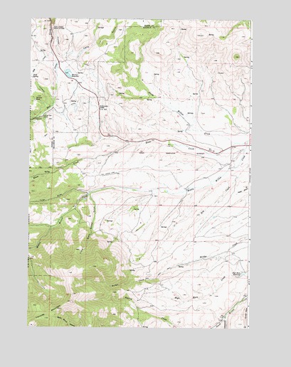
Eldorado Pass, OR USGS Topographic Map
Click on map above to begin viewing in our Map Viewer.

This topographic map contains these locations and features:
Feature Name Type Latitude Longitude GNIS ID View Map
Beam CreekStreamN44.3260°W118.0021°1137623View Map
Between PondLakeN44.3417°W118.1219°1137959View Map
Black Stump GulchValleyN44.3041°W118.0552°1153264View Map
Cottonwood CreekStreamN44.2560°W118.0133°1140181View Map
Dickson DamDamN44.2726°W118.0025°1155552View Map
Dickson ReservoirReservoirN44.2732°W118.0010°1155553View Map
Ditch SpringSpringN44.3507°W118.1240°1141060View Map
Eldorado PassGapN44.3382°W118.0858°1141724View Map
Eldorado Recreation SiteLocaleN44.3343°W118.1233°1167278View Map
HB MurrayLocaleN44.3591°W118.1052°1156477View Map
High Horn ReservoirReservoirN44.2721°W118.0043°1143569View Map
Ironside C and H CorralsLocaleN44.3354°W118.1183°1144125View Map
Lake GulchValleyN44.3541°W118.1063°1144779View Map
Little Black Stump GulchValleyN44.3046°W118.0908°1145102View Map
Milk CreekStreamN44.3607°W118.1133°1146209View Map
Murray DamDamN44.3532°W118.1060°1153922View Map
Murray ReservoirReservoirN44.3529°W118.1035°1146689View Map
Murray Reservoir Recreation SiteLocaleN44.3527°W118.1022°1156478View Map
North Willow CreekStreamN44.3252°W118.0091°1147073View Map
Tyler DrawValleyN44.3038°W118.0919°1151629View Map
Unity Forest State ParkParkN44.3713°W118.1130°1151659View Map

Note: Coordinates in the location and feature list above are referenced to NAD83 datum.


Copyright (C) 2008-2025 Ryan Niemi / Sunset Dynamics ... All Rights Reserved