TopoQuest Logo
Do you find TopoQuest useful?
Help keep TopoQuest running and adding new maps/features by donating!
Bitcoin:  19c7KJd3qBynnjoSw5npx9KScwjBe4ifkT
Litecoin:  LXs6TkuXGGXo1vDsWCkWVdjQX94eUKd6ui
Home View Maps Find Maps Find Places Resources & Links


Unity, Oregon Topographic Map

USGS Map Title: Unity, OR
USGS Map MRC: 44118D2
DRG (GeoTIFF) Download: o44118d2.tif


Neighboring USGS Topographic Map Quads:


  Pogue Point, OR  
44118E3
 

  Unity Reservoir, OR  
44118E2
 

  Beaverdam Creek, OR  
44118E1
 

  Rail Gulch, OR  
44118D3
 

  Unity, OR  
44118D2
 

  Hereford, OR  
44118D1
 

  Bullrun Rock, OR  
44118C3
 

  Rastus Mountain, OR  
44118C2
 

  Eldorado Pass, OR  
44118C1


Map MRC Location:

N45°
W119°
N45°
W118°
H8 H7 H6 H5 H4 H3 H2 H1
G8 G7 G6 G5 G4 G3 G2 G1
F8 F7 F6 F5 F4 F3 F2 F1
E8 E7 E6 E5 E4 E3 E2 E1
D8 D7 D6 D5 D4 D3 D2 D1
C8 C7 C6 C5 C4 C3 C2 C1
B8 B7 B6 B5 B4 B3 B2 B1
A8 A7 A6 A5 A4 A3 A2 A1
N44°
W119°
N44°
W118°

Unity, OR USGS 1:24K Topographic Map Preview:
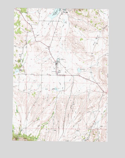
Unity, OR USGS Topographic Map
Click on map above to begin viewing in our Map Viewer.

This topographic map contains these locations and features:
Feature Name Type Latitude Longitude GNIS ID View Map
Burnt River SchoolSchoolN44.4398°W118.1919°1139009View Map
City of UnityCivilN44.4491°W118.1881°2412133View Map
Colt Ware DitchCanalN44.4932°W118.1280°1153975View Map
Curop DitchCanalN44.4763°W118.2052°1153981View Map
Denny FlatFlatN44.4702°W118.1427°1140898View Map
Denny PondLakeN44.4714°W118.1419°1140899View Map
Dry GulchValleyN44.4085°W118.1308°1141329View Map
Ellingson Lumber Company Airstrip (historical)AirportN44.4499°W118.1844°1154053View Map
Elms DamDamN44.4439°W118.1648°1155557View Map
Elms DitchCanalN44.4313°W118.2283°1141841View Map
Elms ReservoirReservoirN44.4422°W118.1629°1141842View Map
Haskins GulchValleyN44.4541°W118.2177°1153980View Map
High Line DitchCanalN44.4999°W118.1394°1153983View Map
Job CreekStreamN44.4971°W118.1858°1144287View Map
Johnson GulchValleyN44.3941°W118.1377°1144353View Map
Long CreekStreamN44.3785°W118.1494°1145397View Map
Morfitt DamDamN44.4256°W118.1942°1153911View Map
Morfitt ReservoirReservoirN44.4240°W118.1925°1146445View Map
Murray PastureFlatN44.3779°W118.1527°1146687View Map
Payton GulchValleyN44.3849°W118.2485°1147516View Map
Pole CreekStreamN44.4516°W118.2383°1147844View Map
Powell GulchValleyN44.4621°W118.2369°1147965View Map
Powell RanchLocaleN44.4621°W118.2369°1167284View Map
Record MineMineN44.3774°W118.2463°1148269View Map
Ripley GulchValleyN44.4218°W118.1669°1148479View Map
Sagebrush GulchValleyN44.4443°W118.2010°1153976View Map
Shirts CreekStreamN44.3924°W118.2049°1149405View Map
South Fork Burnt RiverStreamN44.4896°W118.2010°1149941View Map
Tiger DitchCanalN44.4749°W118.2330°1153978View Map
UnityPopulated PlaceN44.4374°W118.1927°1151657View Map
Unity CemeteryCemeteryN44.4547°W118.2405°1151658View Map
Unity City HallBuildingN44.4376°W118.1825°2700425View Map
Unity Lake State Recreation SiteParkN44.4989°W118.1872°1151660View Map
Unity Post OfficePost OfficeN44.4375°W118.1909°1166086View Map
Unity Ranger StationBuildingN44.4354°W118.1874°1156482View Map
Unity Volunteer Fire DepartmentBuildingN44.4375°W118.1832°2576551View Map
Unity Wastewater Treatment LagoonLocaleN44.4526°W118.1870°2697196View Map
Warm SpringSpringN44.4360°W118.2497°1153977View Map
Wham Whited DitchCanalN44.4916°W118.2122°1153979View Map
Whited DamDamN44.4426°W118.2436°1153910View Map
Whited ReservoirReservoirN44.4399°W118.2455°1152254View Map
Williams DitchCanalN44.3802°W118.1649°1152389View Map

Note: Coordinates in the location and feature list above are referenced to NAD83 datum.


Copyright (C) 2008-2024 Ryan Niemi / Sunset Dynamics ... All Rights Reserved