TopoQuest Logo
Do you find TopoQuest useful?
Help keep TopoQuest running and adding new maps/features by donating!
Bitcoin:  19c7KJd3qBynnjoSw5npx9KScwjBe4ifkT
Litecoin:  LXs6TkuXGGXo1vDsWCkWVdjQX94eUKd6ui
Home View Maps Find Maps Find Places Resources & Links


Elgin West, Texas Topographic Map

USGS Map Title: Elgin West, TX
USGS Map MRC: 30097C4
DRG (GeoTIFF) Download: o30097c4.tif


Neighboring USGS Topographic Map Quads:


  Pflugerville East, TX  
30097D5
 

  Coupland, TX  
30097D4
 

  Structure, TX  
30097D3
 

  Manor, TX  
30097C5
 

  Elgin West, TX  
30097C4
 

  Elgin East, TX  
30097C3
 

  Webberville, TX  
30097B5
 

  Utley, TX  
30097B4
 

  Lake Bastrop, TX  
30097B3


Map MRC Location:

N31°
W98°
N31°
W97°
H8 H7 H6 H5 H4 H3 H2 H1
G8 G7 G6 G5 G4 G3 G2 G1
F8 F7 F6 F5 F4 F3 F2 F1
E8 E7 E6 E5 E4 E3 E2 E1
D8 D7 D6 D5 D4 D3 D2 D1
C8 C7 C6 C5 C4 C3 C2 C1
B8 B7 B6 B5 B4 B3 B2 B1
A8 A7 A6 A5 A4 A3 A2 A1
N30°
W98°
N30°
W97°

Elgin West, TX USGS 1:24K Topographic Map Preview:
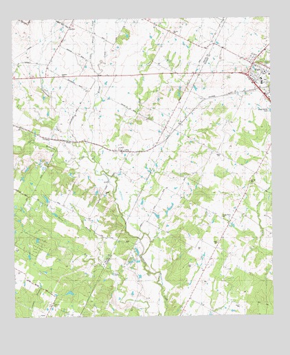
Elgin West, TX USGS Topographic Map
Click on map above to begin viewing in our Map Viewer.

This topographic map contains these locations and features:
Feature Name Type Latitude Longitude GNIS ID View Map
Baker's Place AirportAirportN30.3278°W97.4580°1386598View Map
Bastrop County Constable's Office Precinct 4BuildingN30.3441°W97.3806°2739329View Map
Church of ChristChurchN30.3527°W97.3775°2016490View Map
City of ElginCivilN30.3529°W97.3887°2410423View Map
Cornerstone Baptist ChurchChurchN30.3635°W97.3761°2016474View Map
Cottonwood CreekStreamN30.3172°W97.4642°1373232View Map
Dry CreekStreamN30.3152°W97.4603°1373464View Map
Elgin Elementary SchoolSchoolN30.3496°W97.3798°2002944View Map
Elgin High SchoolSchoolN30.3666°W97.4042°2002945View Map
Elgin Primary SchoolSchoolN30.3491°W97.3797°2002946View Map
Elm CreekStreamN30.3383°W97.4378°1373638View Map
Elm Grove SchoolSchoolN30.3369°W97.4444°1335389View Map
Evangelical Free ChurchChurchN30.3549°W97.3828°2016492View Map
Harris BranchStreamN30.2708°W97.4578°1337382View Map
Hog Eye CemeteryCemeteryN30.3052°W97.3850°1337892View Map
Kimbro SchoolSchoolN30.3730°W97.4733°1339117View Map
LittigPopulated PlaceN30.3197°W97.4494°1340003View Map
Pentecostal ChurchChurchN30.2547°W97.4094°1343834View Map
Phoenix High SchoolSchoolN30.3479°W97.3785°2002953View Map
Schiller CemeteryCemeteryN30.3691°W97.4219°1346763View Map
Sellers LakeReservoirN30.3022°W97.4601°1864097View Map
Sellers Lake DamDamN30.3035°W97.4586°1864096View Map
Speir CemeteryCemeteryN30.2719°W97.4144°1347640View Map
Union Lee ChurchChurchN30.2558°W97.4811°1349083View Map
Wilbern SpringSpringN30.2999°W97.4922°1998321View Map
Willow CreekStreamN30.3194°W97.4628°1376815View Map
Willow CreekStreamN30.3522°W97.4586°1376820View Map
Wilson CemeteryCemeteryN30.2535°W97.3911°1350255View Map
Youngs Prairie CemeteryCemeteryN30.2910°W97.3997°1350704View Map

Note: Coordinates in the location and feature list above are referenced to NAD83 datum.


Copyright (C) 2008-2025 Ryan Niemi / Sunset Dynamics ... All Rights Reserved