TopoQuest Logo
Do you find TopoQuest useful?
Help keep TopoQuest running and adding new maps/features by donating!
Bitcoin:  19c7KJd3qBynnjoSw5npx9KScwjBe4ifkT
Litecoin:  LXs6TkuXGGXo1vDsWCkWVdjQX94eUKd6ui
Home View Maps Find Maps Find Places Resources & Links


Elizabeth, Minnesota Topographic Map

USGS Map Title: Elizabeth, MN
USGS Map MRC: 46096D2
DRG (GeoTIFF) Download: o46096d2.tif


Neighboring USGS Topographic Map Quads:


  Lawndale, MN  
46096E3
 

  Lake Olaf, MN  
46096E2
 

  Pelican Rapids, MN  
46096E1
 

  Rothsay, MN  
46096D3
 

  Elizabeth, MN  
46096D2
 

  Erhard, MN  
46096D1
 

  Foxhome, MN  
46096C3
 

  Carlisle, MN  
46096C2
 

  Fergus Falls, MN  
46096C1


Map MRC Location:

N47°
W97°
N47°
W96°
H8 H7 H6 H5 H4 H3 H2 H1
G8 G7 G6 G5 G4 G3 G2 G1
F8 F7 F6 F5 F4 F3 F2 F1
E8 E7 E6 E5 E4 E3 E2 E1
D8 D7 D6 D5 D4 D3 D2 D1
C8 C7 C6 C5 C4 C3 C2 C1
B8 B7 B6 B5 B4 B3 B2 B1
A8 A7 A6 A5 A4 A3 A2 A1
N46°
W97°
N46°
W96°

Elizabeth, MN USGS 1:24K Topographic Map Preview:
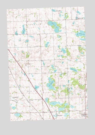
Elizabeth, MN USGS Topographic Map
Click on map above to begin viewing in our Map Viewer.

This topographic map contains these locations and features:
Feature Name Type Latitude Longitude GNIS ID View Map
Altner LakeLakeN46.4301°W96.1463°639309View Map
Augustana Lutheran ChurchChurchN46.3797°W96.1289°2073087View Map
Christopherson LakeLakeN46.4513°W96.1611°641203View Map
City of ElizabethCivilN46.3798°W96.1310°2394646View Map
ElizabethPopulated PlaceN46.3797°W96.1292°643253View Map
Elizabeth Fire DepartmentBuildingN46.3795°W96.1306°2073086View Map
Elizabeth Post Office (historical)Post OfficeN46.3797°W96.1289°2073083View Map
Evangelical Lutheran Kirchof CemeteryCemeteryN46.3775°W96.1289°2072731View Map
Friborg ChurchChurchN46.4413°W96.1970°643949View Map
Friborg Lutheran Church Cemetery (historical)CemeteryN46.4333°W96.1750°2072667View Map
German Evangelical Cemetery (historical)CemeteryN46.3833°W96.1439°2072733View Map
Hedemarken ChurchChurchN46.3977°W96.2140°644827View Map
Hedemarken Lutheran Church CemeteryCemeteryN46.3972°W96.2122°2072669View Map
Houland LakeLakeN46.4825°W96.1757°645252View Map
KBRF-FM (Fergus Falls)TowerN46.4683°W96.1987°663046View Map
Knobel LakeLakeN46.4694°W96.1316°646212View Map
Lake HaldorsenLakeN46.4147°W96.1839°644570View Map
Moen LakeLakeN46.4588°W96.1887°648012View Map
Nelson LakeLakeN46.4758°W96.2240°648458View Map
Old Friborg CemeteryCemeteryN46.4414°W96.1958°2072668View Map
Oscar Post Office (historical)Post OfficeN46.3833°W96.2472°2072992View Map
Oscar State Wildlife Management AreaParkN46.3997°W96.2456°649016View Map
Pelican River DamDamN46.3800°W96.1253°1776223View Map
Peterson LakeLakeN46.4672°W96.1678°649333View Map
Saint Elizabeth's Catholic ChurchChurchN46.3831°W96.1342°2072732View Map
Saint Elizabeth's Catholic ChurchChurchN46.3797°W96.1289°2073085View Map
Saint John Lutheran ChurchChurchN46.3797°W96.1289°2073084View Map
School Number 111 (historical)SchoolN46.3836°W96.2481°2126795View Map
School Number 125 (historical)SchoolN46.3911°W96.1969°2126781View Map
School Number 62 (historical)SchoolN46.4342°W96.1864°2126780View Map
School Number 83 (historical)SchoolN46.4786°W96.2183°2126775View Map
School Number 89 (historical)SchoolN46.4858°W96.1872°2126776View Map
South Friborg CemeteryCemeteryN46.3833°W96.1973°652309View Map
Township of OscarCivilN46.4132°W96.2181°665227View Map
Zion Elizabeth CemeteryCemeteryN46.4450°W96.1328°654490View Map

Note: Coordinates in the location and feature list above are referenced to NAD83 datum.


Copyright (C) 2008-2025 Ryan Niemi / Sunset Dynamics ... All Rights Reserved