TopoQuest Logo
Do you find TopoQuest useful?
Help keep TopoQuest running and adding new maps/features by donating!
Bitcoin:  19c7KJd3qBynnjoSw5npx9KScwjBe4ifkT
Litecoin:  LXs6TkuXGGXo1vDsWCkWVdjQX94eUKd6ui
Home View Maps Find Maps Find Places Resources & Links


Elizabethtown South, North Carolina Topographic Map

USGS Map Title: Elizabethtown South, NC
USGS Map MRC: 34078E5
DRG (GeoTIFF) Download: o34078e5.tif


Neighboring USGS Topographic Map Quads:


  Dublin, NC  
34078F6
 

  Elizabethtown North, NC  
34078F5
 

  White Lake, NC  
34078F4
 

  Abbottsburg, NC  
34078E6
 

  Elizabethtown South, NC  
34078E5
 

  Singletary Lake, NC  
34078E4
 

  Clarkton, NC  
34078D6
 

  Emerson, NC  
34078D5
 

  Council, NC  
34078D4


Map MRC Location:

N35°
W79°
N35°
W78°
H8 H7 H6 H5 H4 H3 H2 H1
G8 G7 G6 G5 G4 G3 G2 G1
F8 F7 F6 F5 F4 F3 F2 F1
E8 E7 E6 E5 E4 E3 E2 E1
D8 D7 D6 D5 D4 D3 D2 D1
C8 C7 C6 C5 C4 C3 C2 C1
B8 B7 B6 B5 B4 B3 B2 B1
A8 A7 A6 A5 A4 A3 A2 A1
N34°
W79°
N34°
W78°

Elizabethtown South, NC USGS 1:24K Topographic Map Preview:
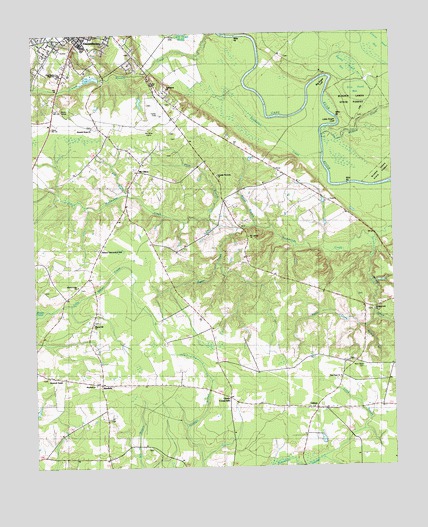
Elizabethtown South, NC USGS Topographic Map
Click on map above to begin viewing in our Map Viewer.

This topographic map contains these locations and features:
Feature Name Type Latitude Longitude GNIS ID View Map
Beloved Tabernacle of GodChurchN34.5627°W78.6014°1004103View Map
Big Sugar LoafBendN34.6127°W78.5214°981460View Map
Bladen CountyCivilN34.6146°W78.5636°1026336View Map
Bladen County HospitalHospitalN34.6226°W78.6083°2094859View Map
BluefieldPopulated PlaceN34.5249°W78.6020°1006135View Map
Bluefield ChurchChurchN34.5243°W78.6042°981638View Map
Bog BranchStreamN34.5793°W78.5922°981677View Map
Broad BranchStreamN34.5704°W78.5478°981926View Map
Clarks CrossroadsPopulated PlaceN34.5210°W78.5567°1006161View Map
Cotton Head BaySwampN34.6218°W78.5042°983594View Map
Cross PondReservoirN34.6122°W78.6033°1025270View Map
Cross Pond DamDamN34.6135°W78.6014°998101View Map
Curtis L Brown Jr FieldAirportN34.6015°W78.5812°1025858View Map
Davis CemeteryCemeteryN34.5971°W78.5767°983989View Map
Davis CreekStreamN34.5441°W78.5067°1025278View Map
Doubles BranchStreamN34.5118°W78.5725°1025289View Map
East Bladen High SchoolSchoolN34.6138°W78.6153°1004100View Map
Elizabethtown Airport Industrial ParkLocaleN34.6023°W78.5900°2505175View Map
Elizabethtown Nursing CenterBuildingN34.6216°W78.6063°2505790View Map
Elizabethtown Rescue SquadBuildingN34.6229°W78.6062°2720642View Map
Fellowship ChurchChurchN34.6091°W78.5778°1004101View Map
Friendly Riverside ChurchChurchN34.5841°W78.5606°1004102View Map
Kemp ChurchChurchN34.5910°W78.5756°987911View Map
Lamb BranchStreamN34.5104°W78.5106°988106View Map
Lee CemeteryCemeteryN34.6007°W78.5114°988291View Map
LisbonPopulated PlaceN34.5171°W78.5270°988521View Map
Lisbon Baptist ChurchChurchN34.5173°W78.5278°2505503View Map
Lisbon Volunteer Fire DepartmentBuildingN34.5146°W78.5280°2638163View Map
Little Horseshoe SwampStreamN34.5110°W78.5256°1025479View Map
Little Sugar LoafBendN34.5996°W78.5178°988783View Map
Little Whites CreekStreamN34.5438°W78.6225°988802View Map
McCall CemeteryCemeteryN34.5063°W78.5853°989529View Map
McKoy CemeteryCemeteryN34.5507°W78.5122°989604View Map
Mears CemeteryCemeteryN34.5954°W78.5739°989693View Map
Mount Calvary ChurchChurchN34.5666°W78.5500°1025561View Map
Mount OlivePopulated PlaceN34.5882°W78.5867°990456View Map
Mount Olive CemeteriesCemeteryN34.5979°W78.5836°990459View Map
Mount Zion African Methodist Episcopal Zion ChurchChurchN34.6240°W78.6129°2505710View Map
Mulford CreekStreamN34.5946°W78.5236°1025569View Map
New Hope CemeteryCemeteryN34.5288°W78.5106°990984View Map
New Hope ChurchChurchN34.5260°W78.5189°990991View Map
Pemberton CreekStreamN34.5929°W78.5283°992011View Map
Pilgrim Hill ChurchChurchN34.5421°W78.6045°992200View Map
Pleasant Grove ChurchChurchN34.5982°W78.5986°1026015View Map
Plum BranchStreamN34.5710°W78.5617°992592View Map
Rice Pond BaySwampN34.6077°W78.5083°993285View Map
Riverside ChurchChurchN34.5668°W78.5497°993387View Map
Round Pond BaySwampN34.6158°W78.5137°993753View Map
Savannah Temple ChurchChurchN34.5266°W78.6206°994385View Map
Sutton CemeteryCemeteryN34.5910°W78.5114°995727View Map
Town of ElizabethtownCivilN34.6238°W78.6096°2406434View Map
Township of ElizabethtownCivilN34.5906°W78.6135°1026429View Map
True Vine Holiness ChurchChurchN34.5545°W78.6181°2506289View Map
Turnbull CreekStreamN34.6246°W78.5567°1025761View Map
Unity Fellowship Christian ChurchChurchN34.5238°W78.5910°2506298View Map
Upton CreekStreamN34.5691°W78.5539°1025766View Map
Warson CemeteryCemeteryN34.5304°W78.5153°996816View Map
Watson BranchStreamN34.5404°W78.5095°1025778View Map
Whites CreekStreamN34.5638°W78.5058°997249View Map
Whites Creek ChurchChurchN34.5457°W78.5067°997251View Map
Whites Creek ChurchChurchN34.5527°W78.6103°997252View Map

Note: Coordinates in the location and feature list above are referenced to NAD83 datum.


Copyright (C) 2008-2025 Ryan Niemi / Sunset Dynamics ... All Rights Reserved