TopoQuest Logo
Do you find TopoQuest useful?
Help keep TopoQuest running and adding new maps/features by donating!
Bitcoin:  19c7KJd3qBynnjoSw5npx9KScwjBe4ifkT
Litecoin:  LXs6TkuXGGXo1vDsWCkWVdjQX94eUKd6ui
Home View Maps Find Maps Find Places Resources & Links


Ellensburg North, Washington Topographic Map

USGS Map Title: Ellensburg North, WA
USGS Map MRC: 47120A5
DRG (GeoTIFF) Download: o47120a5.tif


Neighboring USGS Topographic Map Quads:


  Swauk Prairie, WA  
47120B6
 

  Reecer Canyon, WA  
47120B5
 

  Naneum Canyon, WA  
47120B4
 

  Thorp, WA  
47120A6
 

  Ellensburg North, WA  
47120A5
 

  Colockum Pass SW, WA  
47120A4
 

  Manastash Creek, WA  
46120H6
 

  Ellensburg South, WA  
46120H5
 

  Kittitas, WA  
46120H4


Map MRC Location:

N48°
W121°
N48°
W120°
H8 H7 H6 H5 H4 H3 H2 H1
G8 G7 G6 G5 G4 G3 G2 G1
F8 F7 F6 F5 F4 F3 F2 F1
E8 E7 E6 E5 E4 E3 E2 E1
D8 D7 D6 D5 D4 D3 D2 D1
C8 C7 C6 C5 C4 C3 C2 C1
B8 B7 B6 B5 B4 B3 B2 B1
A8 A7 A6 A5 A4 A3 A2 A1
N47°
W121°
N47°
W120°

Ellensburg North, WA USGS 1:24K Topographic Map Preview:
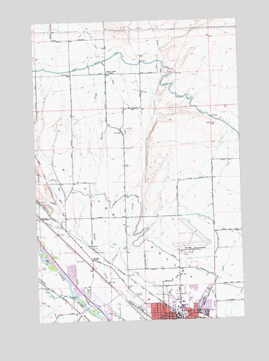
Ellensburg North, WA USGS Topographic Map
Click on map above to begin viewing in our Map Viewer.

This topographic map contains these locations and features:
Feature Name Type Latitude Longitude GNIS ID View Map
Bouillon LibraryBuildingN47.0043°W120.5387°1534193View Map
Bowers FieldAirportN47.0299°W120.5324°1533749View Map
Central Washington UniversitySchoolN47.0050°W120.5377°1517599View Map
City of EllensburgCivilN47.0008°W120.5480°2410430View Map
Currier CreekStreamN47.0065°W120.5826°1518424View Map
Dry CreekStreamN47.0273°W120.6131°1518953View Map
Ellensburg Army Air Field (historical)MilitaryN47.0336°W120.5314°2091967View Map
Ellensburg Golf ClubLocaleN47.0210°W120.6237°2608352View Map
Hebeler Elementary SchoolSchoolN47.0007°W120.5420°1534173View Map
Holy Cross CemeteryCemeteryN47.0101°W120.5664°1520873View Map
Independent Order of Odd Fellows CemeteryCemeteryN47.0110°W120.5201°1524054View Map
Jones CreekStreamN47.0754°W120.5570°1521461View Map
Kittitas ValleyBasinN47.0396°W120.5715°1521708View Map
Kiwanis ParkParkN47.0054°W120.5484°1534179View Map
KQBE-FM (Ellensburg)TowerN47.0057°W120.5165°1534345View Map
McManamy CutoffCrossingN47.0490°W120.6245°1530179View Map
Mount Stuart Elementary SchoolSchoolN47.0084°W120.5592°1534185View Map
Nicholson PavilionBuildingN47.0043°W120.5387°1534186View Map
Reecer Creek SchoolSchoolN47.1032°W120.5806°1524965View Map
Rotor Ranch AirportAirportN47.0892°W120.5867°2770670View Map
West Ellensburg InterchangeCrossingN47.0062°W120.5912°1534210View Map
WoldaleLocaleN47.0415°W120.5892°1530022View Map
Woldale SchoolSchoolN47.0254°W120.5926°1528274View Map

Note: Coordinates in the location and feature list above are referenced to NAD83 datum.


Copyright (C) 2008-2025 Ryan Niemi / Sunset Dynamics ... All Rights Reserved