TopoQuest Logo
Do you find TopoQuest useful?
Help keep TopoQuest running and adding new maps/features by donating!
Bitcoin:  19c7KJd3qBynnjoSw5npx9KScwjBe4ifkT
Litecoin:  LXs6TkuXGGXo1vDsWCkWVdjQX94eUKd6ui
Home View Maps Find Maps Find Places Resources & Links


Elm Mott, Texas Topographic Map

USGS Map Title: Elm Mott, TX
USGS Map MRC: 31097F1
DRG (GeoTIFF) Download: o31097f1.tif


Neighboring USGS Topographic Map Quads:


  Aquilla, TX  
31097G2
 

  West, TX  
31097G1
 

  Penelope, TX  
31096G8
 

  Gholson, TX  
31097F2
 

  Elm Mott, TX  
31097F1
 

  Axtell, TX  
31096F8
 

  Waco West, TX  
31097E2
 

  Waco East, TX  
31097E1
 

  Elk, TX  
31096E8


Map MRC Location:

N32°
W98°
N32°
W97°
H8 H7 H6 H5 H4 H3 H2 H1
G8 G7 G6 G5 G4 G3 G2 G1
F8 F7 F6 F5 F4 F3 F2 F1
E8 E7 E6 E5 E4 E3 E2 E1
D8 D7 D6 D5 D4 D3 D2 D1
C8 C7 C6 C5 C4 C3 C2 C1
B8 B7 B6 B5 B4 B3 B2 B1
A8 A7 A6 A5 A4 A3 A2 A1
N31°
W98°
N31°
W97°

Elm Mott, TX USGS 1:24K Topographic Map Preview:
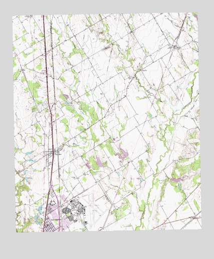
Elm Mott, TX USGS Topographic Map
Click on map above to begin viewing in our Map Viewer.

This topographic map contains these locations and features:
Feature Name Type Latitude Longitude GNIS ID View Map
City of Lacy-LakeviewCivilN31.6293°W97.1052°2411590View Map
City of LeroyCivilN31.7322°W97.0214°2410823View Map
City of RossCivilN31.7282°W97.1123°2411002View Map
Concord CemeteryCemeteryN31.6352°W97.0614°1354855View Map
Connally Elementary SchoolSchoolN31.6391°W97.1017°2007592View Map
Connally High SchoolSchoolN31.6391°W97.1017°2007593View Map
Connally Intermediate and Middle SchoolSchoolN31.6391°W97.1017°2007594View Map
Connally SchoolSchoolN31.6407°W97.1017°1354878View Map
Cottonwood CreekStreamN31.6863°W97.0164°1355100View Map
DPS HeliportAirportN31.6400°W97.0919°1384837View Map
Echols Memorial Church of God in ChristChurchN31.6266°W97.1039°2022287View Map
Elm CreekStreamN31.6918°W97.0178°1373641View Map
Elm MottPopulated PlaceN31.6718°W97.0989°1356982View Map
Elm Mott CemeteryCemeteryN31.6557°W97.0842°1356983View Map
Elm Mott DivisionCivilN31.6800°W97.1019°1938720View Map
Elm Mott Learning CenterSchoolN31.6710°W97.1011°2007604View Map
Elm Mott Post OfficePost OfficeN31.6707°W97.1022°2732341View Map
Elm Mott Volunteer Fire DepartmentBuildingN31.6702°W97.1029°2552270View Map
Gerald CemeteryCemeteryN31.7132°W97.0458°1357966View Map
Gerald ChurchChurchN31.7174°W97.0383°1357967View Map
James Connally Air Force Base (historical)MilitaryN31.6389°W97.0761°2105526View Map
L - 3 Integrated Systems Fire Department / First RespondersBuildingN31.6378°W97.0794°2552540View Map
Lacy Lakeview Fire Department SubstationBuildingN31.6357°W97.1044°2552186View Map
Lacy-LakeviewPopulated PlaceN31.6293°W97.1028°1360823View Map
Lakeview AcademySchoolN31.6688°W97.1011°2007590View Map
Lakeview United Methodist ChurchChurchN31.6285°W97.1042°2022256View Map
LeroyPopulated PlaceN31.7316°W97.0178°1361106View Map
Leroy Post OfficePost OfficeN31.7306°W97.0176°2731809View Map
Linden HallLocaleN31.6746°W97.0894°1361219View Map
Little Tehuacana CreekStreamN31.6357°W97.0386°1374613View Map
New Zion ChurchChurchN31.6579°W97.0786°1363833View Map
NorthcrestPopulated PlaceN31.6366°W97.0997°1388557View Map
Opportunity Learning Center - LorenaSchoolN31.6354°W97.0844°2007633View Map
Post Oak CreekStreamN31.6596°W97.0650°1365647View Map
Rice CreekStreamN31.7157°W97.0008°1375726View Map
Roberts CreekStreamN31.6902°W97.0128°1366591View Map
RossPopulated PlaceN31.7185°W97.1192°1380459View Map
Ross Post OfficePost OfficeN31.7188°W97.1184°2732115View Map
Ross Volunteer Fire DepartmentBuildingN31.7173°W97.1199°2552571View Map
Soil Conservation Service Site 14 DamDamN31.6552°W97.0203°1862322View Map
Soil Conservation Service Site 14 ReservoirReservoirN31.6552°W97.0203°1862323View Map
Soil Conservation Service Site 15 DamDamN31.6668°W97.0503°1862324View Map
Soil Conservation Service Site 15 ReservoirReservoirN31.6668°W97.0503°1862325View Map
Soil Conservation Service Site 16 DamDamN31.7018°W97.0886°1862326View Map
Soil Conservation Service Site 16 ReservoirReservoirN31.7018°W97.0886°1862327View Map
Soil Conservation Service Site 17 DamDamN31.6618°W97.0653°1862328View Map
Soil Conservation Service Site 17 ReservoirReservoirN31.6618°W97.0653°1862329View Map
Soil Conservation Service Site 18 DamDamN31.6618°W97.0753°1862330View Map
Soil Conservation Service Site 18 ReservoirReservoirN31.6618°W97.0753°1862331View Map
Spring LakeReservoirN31.6371°W97.1086°1369026View Map
Stanfield CemeteryCemeteryN31.6266°W97.1058°1369096View Map
Texas Highway Patrol OfficeBuildingN31.6401°W97.0931°2739401View Map
Texas State Technical College Waco Police DepartmentBuildingN31.6343°W97.0792°2739474View Map
TSTC Waco AirportAirportN31.6335°W97.0691°1384838View Map
Waco Army Air Field (historical)MilitaryN31.6389°W97.0772°2096590View Map
Wildcat CreekStreamN31.6518°W97.0325°1371514View Map

Note: Coordinates in the location and feature list above are referenced to NAD83 datum.


Copyright (C) 2008-2024 Ryan Niemi / Sunset Dynamics ... All Rights Reserved