TopoQuest Logo
Do you find TopoQuest useful?
Help keep TopoQuest running and adding new maps/features by donating!
Bitcoin:  19c7KJd3qBynnjoSw5npx9KScwjBe4ifkT
Litecoin:  LXs6TkuXGGXo1vDsWCkWVdjQX94eUKd6ui
Home View Maps Find Maps Find Places Resources & Links


Emelle, Alabama Topographic Map

USGS Map Title: Emelle, AL
USGS Map MRC: 32088F3
DRG (GeoTIFF) Download: o32088f3.tif


Neighboring USGS Topographic Map Quads:


  Scooba, MS  
32088G4
 

  Geiger, AL  
32088G3
 

  Gainesville, AL  
32088G2
 

  Porterville, MS  
32088F4
 

  Emelle, AL  
32088F3
 

  Epes West, AL  
32088F2
 

  Tamola, MS  
32088E4
 

  Boyd, AL  
32088E3
 

  Livingston, AL  
32088E2


Map MRC Location:

N33°
W89°
N33°
W88°
H8 H7 H6 H5 H4 H3 H2 H1
G8 G7 G6 G5 G4 G3 G2 G1
F8 F7 F6 F5 F4 F3 F2 F1
E8 E7 E6 E5 E4 E3 E2 E1
D8 D7 D6 D5 D4 D3 D2 D1
C8 C7 C6 C5 C4 C3 C2 C1
B8 B7 B6 B5 B4 B3 B2 B1
A8 A7 A6 A5 A4 A3 A2 A1
N32°
W89°
N32°
W88°

Emelle, AL USGS 1:24K Topographic Map Preview:
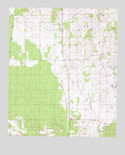
Emelle, AL USGS Topographic Map
Click on map above to begin viewing in our Map Viewer.

This topographic map contains these locations and features:
Feature Name Type Latitude Longitude GNIS ID View Map
Bell CemeteryCemeteryN32.6979°W88.2609°113855View Map
Bethel (historical)Populated PlaceN32.7299°W88.2792°134083View Map
Bethel ChurchChurchN32.7293°W88.2795°114056View Map
Boney CemeteryCemeteryN32.7429°W88.3511°114724View Map
Brown ChapelChurchN32.6790°W88.3003°158795View Map
C E Boyd DamDamN32.6535°W88.2550°130862View Map
C E Boyd LakeReservoirN32.6549°W88.2558°130861View Map
Central CemeteryCemeteryN32.6921°W88.2995°115883View Map
Danner CemeteryCemeteryN32.6512°W88.2859°117060View Map
Dawsey ChurchChurchN32.7443°W88.3145°158812View Map
EmellePopulated PlaceN32.7293°W88.3145°155060View Map
Emelle ChurchChurchN32.7287°W88.3170°134130View Map
Emelle Post OfficePost OfficeN32.7299°W88.3157°168883View Map
Emelle Volunteer Fire DepartmentBuildingN32.7299°W88.3155°2691253View Map
Grindstone PrairieAreaN32.7085°W88.3167°141115View Map
HamnerPopulated PlaceN32.7435°W88.2692°119659View Map
Hutchenson CemeteryCemeteryN32.7487°W88.2545°158431View Map
Little Sanusi CreekStreamN32.6343°W88.3078°121882View Map
Looksookolo CreekStreamN32.6854°W88.2884°134181View Map
Mount Pilgrim Primitive Baptist ChurchChurchN32.6357°W88.2603°158024View Map
Mount Pilgrim School (historical)SchoolN32.6357°W88.2603°134203View Map
Mount Zion Baptist ChurchChurchN32.7121°W88.2773°158034View Map
Mount Zion School (historical)SchoolN32.7124°W88.2778°134209View Map
New Bethel ChurchChurchN32.6926°W88.2556°152604View Map
Old Side CemeteryCemeteryN32.6912°W88.2525°152795View Map
Roy CemeteryCemeteryN32.7062°W88.2672°126003View Map
Saint Peters ChurchChurchN32.7010°W88.2842°126204View Map
Shiloh Zion Baptist ChurchChurchN32.6426°W88.2948°158084View Map
SledgePopulated PlaceN32.6996°W88.3100°157074View Map
Sumter SchoolSchoolN32.7012°W88.2859°134271View Map
Sun Light Baptist ChurchChurchN32.7457°W88.2670°158135View Map
Town of EmelleCivilN32.7287°W88.3165°2406447View Map
West Union Baptist ChurchChurchN32.6990°W88.3406°158104View Map

Note: Coordinates in the location and feature list above are referenced to NAD83 datum.


Copyright (C) 2008-2024 Ryan Niemi / Sunset Dynamics ... All Rights Reserved