TopoQuest Logo
Do you find TopoQuest useful?
Help keep TopoQuest running and adding new maps/features by donating!
Bitcoin:  19c7KJd3qBynnjoSw5npx9KScwjBe4ifkT
Litecoin:  LXs6TkuXGGXo1vDsWCkWVdjQX94eUKd6ui
Home View Maps Find Maps Find Places Resources & Links


Gainesville, Alabama Topographic Map

USGS Map Title: Gainesville, AL
USGS Map MRC: 32088G2
DRG (GeoTIFF) Download: o32088g2.tif


Neighboring USGS Topographic Map Quads:


  Panola, AL  
32088H3
 

  Warsaw, AL  
32088H2
 

  West Greene, AL  
32088H1
 

  Geiger, AL  
32088G3
 

  Gainesville, AL  
32088G2
 

  Boligee, AL  
32088G1
 

  Emelle, AL  
32088F3
 

  Epes West, AL  
32088F2
 

  Epes East, AL  
32088F1


Map MRC Location:

N33°
W89°
N33°
W88°
H8 H7 H6 H5 H4 H3 H2 H1
G8 G7 G6 G5 G4 G3 G2 G1
F8 F7 F6 F5 F4 F3 F2 F1
E8 E7 E6 E5 E4 E3 E2 E1
D8 D7 D6 D5 D4 D3 D2 D1
C8 C7 C6 C5 C4 C3 C2 C1
B8 B7 B6 B5 B4 B3 B2 B1
A8 A7 A6 A5 A4 A3 A2 A1
N32°
W89°
N32°
W88°

Gainesville, AL USGS 1:24K Topographic Map Preview:
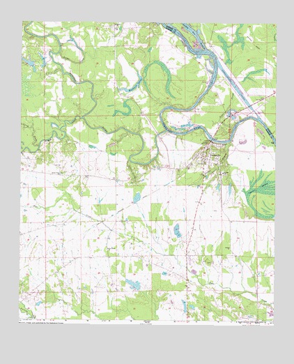
Gainesville, AL USGS Topographic Map
Click on map above to begin viewing in our Map Viewer.

This topographic map contains these locations and features:
Feature Name Type Latitude Longitude GNIS ID View Map
Antioch ChurchChurchN32.7801°W88.1470°113150View Map
Archie Institute School (historical)SchoolN32.7790°W88.2150°134075View Map
Barns LakeReservoirN32.8559°W88.2452°131053View Map
Barns PondReservoirN32.8571°W88.2395°131047View Map
Black Belt Community Health CenterHospitalN32.7743°W88.1672°134090View Map
Bodka CreekStreamN32.8335°W88.2200°667361View Map
Buchanan DamDamN32.7635°W88.1900°131012View Map
Buchannon LakeLakeN32.7649°W88.1938°134100View Map
Caney CreekStreamN32.8218°W88.2409°115577View Map
Cedar CreekStreamN32.8162°W88.1967°115740View Map
Chambers BarBarN32.8571°W88.1559°134105View Map
Cherry BluffCliffN32.8351°W88.1381°132494View Map
Colgins Island (historical)IslandN32.8276°W88.1459°134117View Map
Cypress SwampLakeN32.7950°W88.1342°117005View Map
Daisy Falls DamDamN32.7535°W88.1684°130992View Map
Daisy Falls LakeReservoirN32.7563°W88.1688°130993View Map
Damsite East Bank Public Use AreaParkN32.8474°W88.1556°132760View Map
Damsite West Bank Public Use AreaParkN32.8490°W88.1572°134124View Map
Folsum BranchStreamN32.8240°W88.1472°118472View Map
Forrest MemorialParkN32.8232°W88.1584°118513View Map
GainesvillePopulated PlaceN32.8210°W88.1589°157962View Map
Gainesville Access AreaParkN32.8346°W88.1397°132759View Map
Gainesville BarBarN32.8251°W88.1556°132558View Map
Gainesville DivisionCivilN32.7778°W88.2172°165956View Map
Gainesville Ferry (historical)CrossingN32.8254°W88.1561°132559View Map
Gainesville Headstart SchoolSchoolN32.8112°W88.1506°134141View Map
Gainesville Historic DistrictParkN32.8168°W88.1575°158673View Map
Gainesville Post OfficePost OfficeN32.8221°W88.1600°168886View Map
Gainesville Volunteer Fire DepartmentBuildingN32.8231°W88.1552°2691460View Map
Gibbs PondLakeN32.8090°W88.1722°134144View Map
Hill Ranch DamDamN32.7868°W88.1700°131022View Map
Hill Ranch PondReservoirN32.7854°W88.1720°131021View Map
Holts BarBarN32.8399°W88.1636°132584View Map
Lower Chicken Cock BarBarN32.8621°W88.1664°132620View Map
Main-Yankee Street Historic DistrictParkN32.8226°W88.1559°158674View Map
Negro SloughStreamN32.8296°W88.1459°123687View Map
New Bethel Baptist ChurchChurchN32.7796°W88.2070°158039View Map
New Bethel CemeteryCemeteryN32.7768°W88.1967°134214View Map
Nichols Fish FarmLocaleN32.8061°W88.1817°2674741View Map
Norwoods PondLakeN32.8007°W88.1927°134219View Map
Noxubee BarBarN32.8307°W88.1797°132662View Map
Noxubee RiverStreamN32.8335°W88.1722°694218View Map
Noxubee RiverStreamN32.8285°W88.1792°158173View Map
Nubbin BendBendN32.8585°W88.1584°134221View Map
Odd Fellows CemeteryCemeteryN32.8140°W88.1667°134224View Map
Old CemeteryCemeteryN32.8146°W88.1492°124204View Map
P M Norwood DamDamN32.8001°W88.1917°131025View Map
Saint Albans ChurchChurchN32.8157°W88.1595°153240View Map
Scuma CreekStreamN32.8610°W88.2317°153355View Map
Smiths BarBarN32.8321°W88.1331°134256View Map
Smiths Ferry (historical)CrossingN32.8615°W88.1614°132707View Map
Spring Valley Baptist ChurchChurchN32.8101°W88.2306°127270View Map
Springhill ChurchChurchN32.8712°W88.2042°127288View Map
Sumter Farm and Stock Company DamDamN32.8551°W88.2384°131048View Map
Sumter Farm and Stock Company DamDamN32.8585°W88.2467°131052View Map
Sumter Recreation AreaParkN32.8729°W88.1822°134269View Map
Tennessee-Tombigbee WaterwayChannelN32.8390°W88.1667°149553View Map
Town of GainesvilleCivilN32.8149°W88.1608°2406537View Map
Turkey Paw BranchStreamN32.8618°W88.1589°128172View Map
Tutwiler BridgeBridgeN32.8251°W88.1567°128216View Map
Upper Chicken Cock BarBarN32.8693°W88.1747°134280View Map
Whitsetts BluffCliffN32.8379°W88.1736°134286View Map
Whitsetts Ferry (historical)CrossingN32.8293°W88.1789°134287View Map
Whitsetts Old Ford BarBarN32.8429°W88.1611°132750View Map
Whitsitts BarBarN32.8379°W88.1786°132748View Map
Woodward LakesReservoirN32.8471°W88.1936°129224View Map

Note: Coordinates in the location and feature list above are referenced to NAD83 datum.


Copyright (C) 2008-2025 Ryan Niemi / Sunset Dynamics ... All Rights Reserved