TopoQuest Logo
Do you find TopoQuest useful?
Help keep TopoQuest running and adding new maps/features by donating!
Bitcoin:  19c7KJd3qBynnjoSw5npx9KScwjBe4ifkT
Litecoin:  LXs6TkuXGGXo1vDsWCkWVdjQX94eUKd6ui
Home View Maps Find Maps Find Places Resources & Links


Geiger, Alabama Topographic Map

USGS Map Title: Geiger, AL
USGS Map MRC: 32088G3
DRG (GeoTIFF) Download: o32088g3.tif


Neighboring USGS Topographic Map Quads:


  Paulette, MS  
32088H4
 

  Panola, AL  
32088H3
 

  Warsaw, AL  
32088H2
 

  Scooba, MS  
32088G4
 

  Geiger, AL  
32088G3
 

  Gainesville, AL  
32088G2
 

  Porterville, MS  
32088F4
 

  Emelle, AL  
32088F3
 

  Epes West, AL  
32088F2


Map MRC Location:

N33°
W89°
N33°
W88°
H8 H7 H6 H5 H4 H3 H2 H1
G8 G7 G6 G5 G4 G3 G2 G1
F8 F7 F6 F5 F4 F3 F2 F1
E8 E7 E6 E5 E4 E3 E2 E1
D8 D7 D6 D5 D4 D3 D2 D1
C8 C7 C6 C5 C4 C3 C2 C1
B8 B7 B6 B5 B4 B3 B2 B1
A8 A7 A6 A5 A4 A3 A2 A1
N32°
W89°
N32°
W88°

Geiger, AL USGS 1:24K Topographic Map Preview:
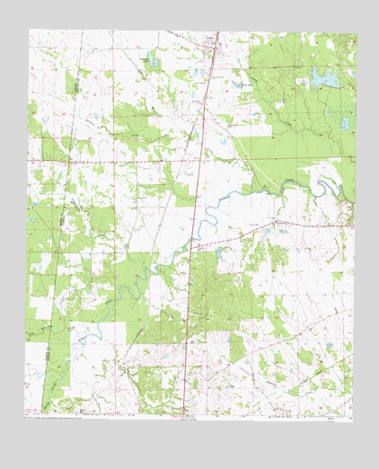
Geiger, AL USGS Topographic Map
Click on map above to begin viewing in our Map Viewer.

This topographic map contains these locations and features:
Feature Name Type Latitude Longitude GNIS ID View Map
Ballard CreekStreamN32.8417°W88.3161°113424View Map
Bodka (historical)LocaleN32.8460°W88.2584°134095View Map
C E Boyd DamDamN32.8085°W88.3000°131031View Map
C E Boyd PondReservoirN32.8085°W88.3000°131030View Map
Dilliard CreekStreamN32.7612°W88.3586°134126View Map
E Q Lunsford Pond DamDamN32.8118°W88.3650°681670View Map
Emelle Treatment FacilityLocaleN32.7987°W88.3084°158429View Map
GeigerPopulated PlaceN32.8682°W88.3050°118884View Map
Geiger United Methodist ChurchChurchN32.8696°W88.3053°157814View Map
Griffin (historical)LocaleN32.7676°W88.3367°134148View Map
Hatchet CreekStreamN32.8219°W88.2883°155092View Map
Ivy (historical)LocaleN32.8326°W88.2936°134166View Map
Jerusalem Baptist ChurchChurchN32.8196°W88.3339°157992View Map
Lacy (historical)LocaleN32.8232°W88.2834°134173View Map
Lacys Ford (historical)CrossingN32.8212°W88.2823°134174View Map
Liars LakeReservoirN32.8561°W88.2953°152030View Map
Mary Winston Baptist ChurchChurchN32.7501°W88.3536°158105View Map
Mitchell School (historical)SchoolN32.7835°W88.2534°134192View Map
Mount Calvary Church (historical)ChurchN32.8674°W88.3239°134197View Map
Mount Harmon ChurchChurchN32.8501°W88.3098°158876View Map
Mount Hermel ChurchChurchN32.8532°W88.3181°134201View Map
Nelson Church (historical)ChurchN32.8201°W88.3345°134211View Map
Nelson School (historical)SchoolN32.8199°W88.3336°134212View Map
New Big LakeReservoirN32.8582°W88.2621°131049View Map
New Mount Calvary ChurchChurchN32.8582°W88.3059°152662View Map
North Sumter Volunteer Fire DepartmentBuildingN32.8479°W88.3076°2691457View Map
Norvelle (historical)LocaleN32.7940°W88.3270°134218View Map
Quilby (historical)LocaleN32.7626°W88.3609°154084View Map
Quilby CreekStreamN32.7621°W88.3609°125382View Map
Shy Hammock CreekStreamN32.7737°W88.3523°126827View Map
Souls Chapel CemeteryCemeteryN32.8426°W88.2997°127109View Map
Souls Chapel Methodist ChurchChurchN32.8568°W88.3084°158090View Map
Souls Chapel School (historical)SchoolN32.8568°W88.3075°134260View Map
Sumter Farm and Stock Company DamDamN32.8568°W88.2600°131050View Map
Sumter Farm and Stock Company DamDamN32.8568°W88.2950°131051View Map
Sumter Farm and Stock Company DamDamN32.8618°W88.3284°131054View Map
Sumter Farm and Stock Company DamDamN32.8735°W88.2717°131067View Map
Sumter Farms and Stock Company Inc Airport (historical)AirportN32.8726°W88.3211°129450View Map
Tifallili CreekStreamN32.7960°W88.3300°127972View Map
Town of GeigerCivilN32.8696°W88.3132°2406556View Map
Williams LakeReservoirN32.8639°W88.3285°153995View Map
Winston (historical)LocaleN32.7685°W88.2534°134288View Map

Note: Coordinates in the location and feature list above are referenced to NAD83 datum.


Copyright (C) 2008-2024 Ryan Niemi / Sunset Dynamics ... All Rights Reserved