TopoQuest Logo
Do you find TopoQuest useful?
Help keep TopoQuest running and adding new maps/features by donating!
Bitcoin:  19c7KJd3qBynnjoSw5npx9KScwjBe4ifkT
Litecoin:  LXs6TkuXGGXo1vDsWCkWVdjQX94eUKd6ui
Home View Maps Find Maps Find Places Resources & Links


Emerald Bay, California Topographic Map

USGS Map Title: Emerald Bay, CA
USGS Map MRC: 38120H1
DRG (GeoTIFF) Download: o38120h1.tif


Neighboring USGS Topographic Map Quads:


  Homewood, CA  
39120A2
 

  Meeks Bay, CA  
39120A1
 

  Glenbrook, NV  
39119A8
 

  Rockbound Valley, CA  
38120H2
 

  Emerald Bay, CA  
38120H1
 

  South Lake Tahoe, CA  
38119H8
 

  Pyramid Peak, CA  
38120G2
 

  Echo Lake, CA  
38120G1
 

  Freel Peak, CA  
38119G8


Map MRC Location:

N39°
W121°
N39°
W120°
H8 H7 H6 H5 H4 H3 H2 H1
G8 G7 G6 G5 G4 G3 G2 G1
F8 F7 F6 F5 F4 F3 F2 F1
E8 E7 E6 E5 E4 E3 E2 E1
D8 D7 D6 D5 D4 D3 D2 D1
C8 C7 C6 C5 C4 C3 C2 C1
B8 B7 B6 B5 B4 B3 B2 B1
A8 A7 A6 A5 A4 A3 A2 A1
N38°
W121°
N38°
W120°

Emerald Bay, CA USGS 1:24K Topographic Map Preview:
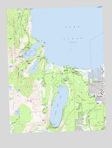
Emerald Bay, CA USGS Topographic Map
Click on map above to begin viewing in our Map Viewer.

This topographic map contains these locations and features:
Feature Name Type Latitude Longitude GNIS ID View Map
Angora LookoutLocaleN38.8824°W120.0546°256260View Map
Azure LakeLakeN38.9207°W120.1243°256392View Map
Balancing RockPillarN38.9915°W120.1080°1733729View Map
Balancing Rock Self-Guided Nature TrailTrailN38.9910°W120.1080°1733730View Map
Baldwin BeachBeachN38.9435°W120.0685°218613View Map
Baldwin Beach CampgroundLocaleN38.9416°W120.0666°1662453View Map
Baldwin Beach Picnic AreaLocaleN38.9410°W120.0641°1733731View Map
Bay View Guard StationLocaleN38.9460°W120.0988°256604View Map
Bayview CampgroundLocaleN38.9446°W120.1005°1733732View Map
Bayview Picnic AreaLocaleN38.9444°W120.0996°275079View Map
Calawee Cove BeachBeachN38.9991°W120.0982°1733736View Map
Camp RichardsonPopulated PlaceN38.9344°W120.0402°1655864View Map
Camp Richardson CampgroundLocaleN38.9319°W120.0427°1733738View Map
Camp Richardson Cross Country Ski AreaLocaleN38.9291°W120.0385°1733739View Map
Camp ShellyLocaleN38.9224°W120.0830°1733741View Map
Cascade CreekStreamN38.9513°W120.0769°258032View Map
Cascade LakeLakeN38.9402°W120.0920°258038View Map
Cathedral CreekStreamN38.8991°W120.0710°258077View Map
Cathedral LakeLakeN38.8938°W120.0818°258079View Map
Cathedral PeakCapeN38.8869°W120.0844°258080View Map
D.L. Bliss State ParkParkN38.9821°W120.0960°259006View Map
Eagle FallsFallsN38.9517°W120.1112°259656View Map
Eagle Falls CampgroundLocaleN38.9521°W120.1138°259657View Map
Eagle Falls TrailTrailN38.9519°W120.1085°1733745View Map
Eagle LakeLakeN38.9421°W120.1223°259661View Map
Eagle PointCapeN38.9655°W120.0788°259672View Map
Emerald BayBayN38.9574°W120.0924°259888View Map
Emerald BayPopulated PlaceN38.9599°W120.0980°1655997View Map
Emerald Bay OverlookLocaleN38.9544°W120.1102°1733751View Map
Emerald Bay State ParkParkN38.9544°W120.0941°259889View Map
Emerald PointCapeN38.9657°W120.0832°259895View Map
Fallen LeafPopulated PlaceN38.8830°W120.0727°1656008View Map
Fallen Leaf CampgroundLocaleN38.9255°W120.0519°260038View Map
Fallen Leaf DamDamN38.9203°W120.0619°1664717View Map
Fallen Leaf LakeReservoirN38.9011°W120.0616°260039View Map
Fallen Leaf LakeReservoirN38.9216°W120.0627°1664718View Map
Fallen Leaf Lake Community Services District Fire DepartmentBuildingN38.8795°W120.0712°2623769View Map
Fallen Leaf MarinaLocaleN38.8799°W120.0657°1733752View Map
Fallen Leaf Post Office (historical)Post OfficeN38.8830°W120.0727°1940067View Map
Fallen Leaf Recreation CenterParkN38.8794°W120.0702°1733753View Map
Fannette IslandIslandN38.9541°W120.1005°260048View Map
Floating Island LakeLakeN38.9021°W120.0789°260210View Map
Fredericks US Forest Service StationLocaleN38.9152°W120.0488°1662435View Map
Gardner MountainSummitN38.9116°W120.0163°1656040View Map
Gilmore LakeLakeN38.8958°W120.1157°260569View Map
Glen Alpine CreekStreamN38.8810°W120.0699°260596View Map
Glen Alpine SpringSpringN38.8753°W120.0970°260597View Map
Granite LakeLakeN38.9376°W120.1102°260754View Map
Hope Lutheran Church of the SierrasChurchN38.9121°W120.0124°1733766View Map
Inspiration PointSummitN38.9463°W120.1005°1656093View Map
Jakes PeakSummitN38.9699°W120.1227°252309View Map
Kiva BeachPopulated PlaceN38.9405°W120.0510°1656114View Map
Kiva BeachBeachN38.9407°W120.0496°1733769View Map
Kiva Beach CampgroundLocaleN38.9388°W120.0482°1662433View Map
Kiva Picnic AreaLocaleN38.9402°W120.0485°275025View Map
Lake Tahoe Basin Management Unit HeadquartersLocaleN38.9160°W120.0088°1655028View Map
Lake Tahoe Basin Management Unit Ranger StationLocaleN38.9121°W120.0060°275026View Map
Lake ValleyPopulated PlaceN38.9299°W120.0046°1656120View Map
Lake Valley Fire Protection District Station 5BuildingN38.8863°W120.0332°2624330View Map
Lampson Plaza Shopping CenterLocaleN38.9132°W120.0038°1733772View Map
Lighthouse TrailTrailN38.9932°W120.0957°1733774View Map
Lily LakeLakeN38.8757°W120.0816°262463View Map
Lower Eagle Point CampgroundLocaleN38.9610°W120.0805°1733776View Map
Maggies PeaksSummitN38.9316°W120.1138°263117View Map
Mount TallacSummitN38.9060°W120.0988°268072View Map
Parson RockPillarN38.9560°W120.1035°264540View Map
Pope BeachBeachN38.9371°W120.0288°264950View Map
Pope Beach CampgroundLocaleN38.9366°W120.0291°1662432View Map
Pope Beach Picnic AreaLocaleN38.9371°W120.0330°1733785View Map
Rubicon PointCapeN38.9994°W120.0960°265646View Map
Rubicon TrailTrailN38.9735°W120.0944°1733788View Map
Sawmill CoreBayN38.9144°W120.0630°275029View Map
Sawmill PondReservoirN38.8891°W120.0261°275028View Map
Snow LakeLakeN38.9177°W120.1147°267318View Map
South Four Center Shopping CenterLocaleN38.9149°W120.0049°1733793View Map
South Lake Tahoe DivisionCivilN38.9200°W120.0383°1935321View Map
South Lake Tahoe Fire Department Station 3BuildingN38.9156°W120.0014°2623872View Map
South Shore Christian Assembly ChurchChurchN38.9149°W120.0091°1733795View Map
South Tahoe High SchoolSchoolN38.9094°W120.0149°267536View Map
Spring CreekPopulated PlaceN38.9291°W120.0649°1733796View Map
Tahoe KeysIslandN38.9363°W120.0138°275027View Map
Tahoe KeysPopulated PlaceN38.9316°W120.0135°1733801View Map
Tahoe Keys MarinaLocaleN38.9377°W120.0057°1733802View Map
Tahoe MountainSummitN38.9102°W120.0357°268062View Map
Tahoe Mountain Group CampgroundLocaleN38.9185°W120.0263°268063View Map
Tahoe ValleyPopulated PlaceN38.9135°W120.0043°268065View Map
Tahoe Valley Elementary SchoolSchoolN38.9219°W120.0033°1733804View Map
Tahoe Valley Post OfficePost OfficeN38.9144°W120.0062°1733740View Map
Tallac CreekStreamN38.9410°W120.0588°268070View Map
Tallac Historical SiteParkN38.9366°W120.0549°1733805View Map
Tallac LakeLakeN38.9120°W120.1120°268071View Map
Tallac PointCliffN38.9405°W120.0541°275080View Map
Tallac VillagePopulated PlaceN38.9219°W120.0218°1656354View Map
Taylor CreekStreamN38.9405°W120.0577°268098View Map
Tea HouseBuildingN38.9544°W120.1005°1733807View Map
Twin PeaksSummitN38.8816°W120.0124°1656376View Map
United States Forest Service Visitors CenterLocaleN38.9366°W120.0544°275081View Map
Upper Eagle Point CampgroundLocaleN38.9524°W120.0849°1733809View Map
VikingsholmLocaleN38.9527°W120.1071°268696View Map
Vikingsholm TrailTrailN38.9571°W120.1052°1733810View Map
Washoe Meadows State ParkParkN38.8807°W120.0235°2570589View Map

Note: Coordinates in the location and feature list above are referenced to NAD83 datum.


Copyright (C) 2008-2024 Ryan Niemi / Sunset Dynamics ... All Rights Reserved