TopoQuest Logo
Do you find TopoQuest useful?
Help keep TopoQuest running and adding new maps/features by donating!
Bitcoin:  19c7KJd3qBynnjoSw5npx9KScwjBe4ifkT
Litecoin:  LXs6TkuXGGXo1vDsWCkWVdjQX94eUKd6ui
Home View Maps Find Maps Find Places Resources & Links


Rockbound Valley, California Topographic Map

USGS Map Title: Rockbound Valley, CA
USGS Map MRC: 38120H2
DRG (GeoTIFF) Download: o38120h2.tif


Neighboring USGS Topographic Map Quads:


  Wentworth Springs, CA  
39120A3
 

  Homewood, CA  
39120A2
 

  Meeks Bay, CA  
39120A1
 

  Loon Lake, CA  
38120H3
 

  Rockbound Valley, CA  
38120H2
 

  Emerald Bay, CA  
38120H1
 

  Kyburz, CA  
38120G3
 

  Pyramid Peak, CA  
38120G2
 

  Echo Lake, CA  
38120G1


Map MRC Location:

N39°
W121°
N39°
W120°
H8 H7 H6 H5 H4 H3 H2 H1
G8 G7 G6 G5 G4 G3 G2 G1
F8 F7 F6 F5 F4 F3 F2 F1
E8 E7 E6 E5 E4 E3 E2 E1
D8 D7 D6 D5 D4 D3 D2 D1
C8 C7 C6 C5 C4 C3 C2 C1
B8 B7 B6 B5 B4 B3 B2 B1
A8 A7 A6 A5 A4 A3 A2 A1
N38°
W121°
N38°
W120°

Rockbound Valley, CA USGS 1:24K Topographic Map Preview:
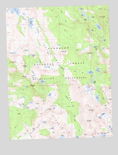
Rockbound Valley, CA USGS Topographic Map
Click on map above to begin viewing in our Map Viewer.

This topographic map contains these locations and features:
Feature Name Type Latitude Longitude GNIS ID View Map
Alta Morris LakeLakeN38.8937°W120.1390°218182View Map
Barrett LakeLakeN38.9048°W120.2298°218697View Map
Camper FlatFlatN38.9413°W120.1841°220516View Map
China FlatFlatN38.9044°W120.1752°221028View Map
Cliff LakeLakeN38.9759°W120.1484°221220View Map
Clyde LakeLakeN38.8755°W120.1692°258485View Map
Crag LakeLakeN38.9917°W120.1564°221783View Map
Crystal RangeRangeN38.9096°W120.2077°258969View Map
Desolation WildernessReserveN38.9210°W120.1722°266637View Map
Dicks LakeLakeN38.9120°W120.1430°222365View Map
Dicks PassGapN38.9052°W120.1352°222366View Map
Dicks PeakSummitN38.9005°W120.1510°222367View Map
Fontanillis LakeLakeN38.9207°W120.1532°223651View Map
Four-Q LakesLakeN38.9430°W120.2024°223749View Map
Fox LakeLakeN38.9934°W120.2278°223787View Map
Gertrude LakeLakeN38.8845°W120.2011°224135View Map
Grouse LakesLakeN38.9610°W120.1357°224664View Map
Half Moon LakeLakeN38.8965°W120.1369°224793View Map
Heather LakeLakeN38.8764°W120.1384°261216View Map
Hidden LakeLakeN38.9865°W120.1522°225243View Map
Highland LakeLakeN38.9569°W120.2417°225291View Map
Highland Lake 1-031 DamDamN38.9569°W120.2419°1663235View Map
Horseshoe LakeLakeN38.9541°W120.2215°225647View Map
Island LakeLakeN38.8753°W120.1877°261832View Map
Jacks PeakSummitN38.8905°W120.1541°226070View Map
Kalmia LakeLakeN38.9108°W120.1252°262068View Map
Lake DorisLakeN38.9056°W120.1958°222524View Map
Lake GenevieveLakeN38.9970°W120.1612°224112View Map
Lake LoisLakeN38.9164°W120.2004°227485View Map
Lake Number FiveLakeN38.9152°W120.2316°254977View Map
Lake Number NineLakeN38.9089°W120.2182°254978View Map
Lake Number ThreeLakeN38.9252°W120.2301°254976View Map
Lake SchmidellReservoirN38.9292°W120.2089°232653View Map
Lake ZitellaLakeN38.9592°W120.2255°238323View Map
Lawrence LakeLakeN38.9090°W120.2256°226964View Map
Leland LakesLakeN38.9341°W120.2182°227017View Map
Lost LakeLakeN38.9082°W120.2348°227708View Map
Lower Velma LakeLakeN38.9387°W120.1411°227797View Map
Maude LakeLakeN38.8904°W120.2101°228241View Map
McConnell LakeLakeN38.9442°W120.2270°228314View Map
McConnell PeakSummitN38.9485°W120.2430°228316View Map
Middle MountainSummitN38.9566°W120.1813°228607View Map
Middle Velma LakeLakeN38.9365°W120.1502°228623View Map
Mosquito PassGapN38.8774°W120.1607°229116View Map
Onion FlatFlatN38.9869°W120.2246°230052View Map
Phipps CreekStreamN38.9646°W120.2032°230601View Map
Phipps LakeLakeN38.9610°W120.1464°230603View Map
Phipps PassGapN38.9602°W120.1419°230604View Map
Phipps PeakSummitN38.9546°W120.1499°230605View Map
Red PeakSummitN38.9255°W120.2213°231366View Map
Rockbound LakeLakeN38.9970°W120.2388°265517View Map
Rockbound PassGapN38.9021°W120.2010°231749View Map
Rockbound ValleyValleyN38.9913°W120.2202°265518View Map
Rubicon 1009-009 DamDamN38.9888°W120.2230°1664137View Map
Rubicon LakeLakeN38.9666°W120.1340°231996View Map
Rubicon PeakSummitN38.9885°W120.1332°231997View Map
Rubicon ReservoirReservoirN38.9852°W120.2210°231998View Map
Schmidell Lake 1-029 DamDamN38.9299°W120.2060°1663233View Map
Shadow LakeLakeN38.9883°W120.1473°232837View Map
Silver PeakSummitN38.9346°W120.2305°233140View Map
Stony Ridge LakeReservoirN38.9795°W120.1389°235552View Map
Stony Ridge Lake 1-032 DamDamN38.9816°W120.1410°1663236View Map
Susie LakeLakeN38.8820°W120.1274°267992View Map
Top LakeLakeN38.9051°W120.2172°236466View Map
Tyler LakeLakeN38.8807°W120.1987°236741View Map
University of California Cow CampLocaleN38.8994°W120.2399°236862View Map
Upper Velma LakeLakeN38.9283°W120.1490°236931View Map
Willow FlatFlatN38.8830°W120.2199°237913View Map

Note: Coordinates in the location and feature list above are referenced to NAD83 datum.


Copyright (C) 2008-2024 Ryan Niemi / Sunset Dynamics ... All Rights Reserved