TopoQuest Logo
Do you find TopoQuest useful?
Help keep TopoQuest running and adding new maps/features by donating!
Bitcoin:  19c7KJd3qBynnjoSw5npx9KScwjBe4ifkT
Litecoin:  LXs6TkuXGGXo1vDsWCkWVdjQX94eUKd6ui
Home View Maps Find Maps Find Places Resources & Links


Enterprise, Illinois Topographic Map

USGS Map Title: Enterprise, IL
USGS Map MRC: 38088E3
DRG (GeoTIFF) Download: o38088e3.tif


Neighboring USGS Topographic Map Quads:


  Flora, IL  
38088F4
 

  Clay City, IL  
38088F3
 

  Noble, IL  
38088F2
 

  Cisne, IL  
38088E4
 

  Enterprise, IL  
38088E3
 

  Mount Erie, IL  
38088E2
 

  Geff, IL  
38088D4
 

  Fairfield, IL  
38088D3
 

  Albion NW, IL  
38088D2


Map MRC Location:

N39°
W89°
N39°
W88°
H8 H7 H6 H5 H4 H3 H2 H1
G8 G7 G6 G5 G4 G3 G2 G1
F8 F7 F6 F5 F4 F3 F2 F1
E8 E7 E6 E5 E4 E3 E2 E1
D8 D7 D6 D5 D4 D3 D2 D1
C8 C7 C6 C5 C4 C3 C2 C1
B8 B7 B6 B5 B4 B3 B2 B1
A8 A7 A6 A5 A4 A3 A2 A1
N38°
W89°
N38°
W88°

Enterprise, IL USGS 1:24K Topographic Map Preview:
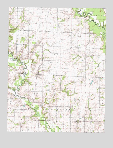
Enterprise, IL USGS Topographic Map
Click on map above to begin viewing in our Map Viewer.

This topographic map contains these locations and features:
Feature Name Type Latitude Longitude GNIS ID View Map
Banker School (historical)SchoolN38.5859°W88.3120°1725095View Map
Barnes CemeteryCemeteryN38.6145°W88.3028°1952648View Map
Barnes School (historical)SchoolN38.5589°W88.3748°1725097View Map
Barth CemeteryCemeteryN38.5273°W88.3323°403939View Map
Brown CemeteryCemeteryN38.5117°W88.2861°404940View Map
Central School (historical)SchoolN38.5156°W88.3125°1725103View Map
Clay City Oil FieldOilfieldN38.5706°W88.3095°424748View Map
Dennis School (historical)SchoolN38.5792°W88.3403°1725107View Map
Elm River ChurchChurchN38.5109°W88.2859°407938View Map
Elm River TownhallBuildingN38.5112°W88.3125°1725108View Map
Endsley CreekStreamN38.5417°W88.3656°408022View Map
EnterprisePopulated PlaceN38.5223°W88.3575°408038View Map
Evangelical CemeteryCemeteryN38.5231°W88.3442°408093View Map
Fitch CemeteryCemeteryN38.5256°W88.2731°408408View Map
Hog Run CreekStreamN38.6062°W88.2531°410354View Map
Johnson School (historical)SchoolN38.5400°W88.3298°1725117View Map
Laird CemeteryCemeteryN38.5248°W88.3620°411692View Map
Laird School (historical)SchoolN38.5120°W88.3481°1725119View Map
Lincoln School (historical)SchoolN38.5259°W88.2575°1725121View Map
Mann School (historical)SchoolN38.5292°W88.2898°1725124View Map
Patterson ChurchChurchN38.6012°W88.3317°415444View Map
Robinson LakeReservoirN38.5526°W88.2653°1691431View Map
Robinson Lake DamDamN38.5517°W88.2650°1691430View Map
Shiloh Church (historical)ChurchN38.5792°W88.2662°1725134View Map
Smith Landing Field (historical)AirportN38.5967°W88.2870°1725135View Map
Thomas School (historical)SchoolN38.6237°W88.3489°1747756View Map
Township of Elm RiverCivilN38.5125°W88.3117°428961View Map
Township of ZifCivilN38.5788°W88.3109°429975View Map
Trinity ChurchChurchN38.5406°W88.3081°419857View Map
Wells CemeteryCemeteryN38.5970°W88.2948°420735View Map
Wells School (historical)SchoolN38.6006°W88.2945°1747759View Map
Williams CemeteryCemeteryN38.5956°W88.2625°421197View Map
Wilson School (historical)SchoolN38.5781°W88.2753°1725141View Map
Woodside School (historical)SchoolN38.5875°W88.3642°1725142View Map
Wright CemeteryCemeteryN38.5875°W88.3564°421518View Map
Zif CemeteryCemeteryN38.5898°W88.3353°421620View Map
Zif ChurchChurchN38.5584°W88.3362°421621View Map
Zif ChurchChurchN38.5781°W88.3306°421622View Map
Zif Post Office (historical)Post OfficeN38.5864°W88.3131°1823942View Map

Note: Coordinates in the location and feature list above are referenced to NAD83 datum.


Copyright (C) 2008-2024 Ryan Niemi / Sunset Dynamics ... All Rights Reserved