TopoQuest Logo
Do you find TopoQuest useful?
Help keep TopoQuest running and adding new maps/features by donating!
Bitcoin:  19c7KJd3qBynnjoSw5npx9KScwjBe4ifkT
Litecoin:  LXs6TkuXGGXo1vDsWCkWVdjQX94eUKd6ui
Home View Maps Find Maps Find Places Resources & Links


Clay City, Illinois Topographic Map

USGS Map Title: Clay City, IL
USGS Map MRC: 38088F3
DRG (GeoTIFF) Download: o38088f3.tif


Neighboring USGS Topographic Map Quads:


  Louisville East, IL  
38088G4
 

  Sailor Springs, IL  
38088G3
 

  Wakefield, IL  
38088G2
 

  Flora, IL  
38088F4
 

  Clay City, IL  
38088F3
 

  Noble, IL  
38088F2
 

  Cisne, IL  
38088E4
 

  Enterprise, IL  
38088E3
 

  Mount Erie, IL  
38088E2


Map MRC Location:

N39°
W89°
N39°
W88°
H8 H7 H6 H5 H4 H3 H2 H1
G8 G7 G6 G5 G4 G3 G2 G1
F8 F7 F6 F5 F4 F3 F2 F1
E8 E7 E6 E5 E4 E3 E2 E1
D8 D7 D6 D5 D4 D3 D2 D1
C8 C7 C6 C5 C4 C3 C2 C1
B8 B7 B6 B5 B4 B3 B2 B1
A8 A7 A6 A5 A4 A3 A2 A1
N38°
W89°
N38°
W88°

Clay City, IL USGS 1:24K Topographic Map Preview:
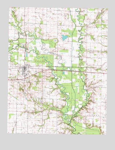
Clay City, IL USGS Topographic Map
Click on map above to begin viewing in our Map Viewer.

This topographic map contains these locations and features:
Feature Name Type Latitude Longitude GNIS ID View Map
Adventist ChurchChurchN38.6573°W88.2514°403364View Map
Big Muddy CreekStreamN38.6378°W88.2962°404423View Map
Black School (historical)SchoolN38.7303°W88.3553°1747713View Map
Brushville School (historical)SchoolN38.7156°W88.2573°1736789View Map
Burcham School (historical)SchoolN38.7212°W88.3128°1747715View Map
Camp TravisPopulated PlaceN38.6600°W88.3314°405507View Map
Clay CityPopulated PlaceN38.6887°W88.3542°406184View Map
Clay City CemeteryCemeteryN38.6762°W88.3495°406185View Map
Clay City Christian ChurchChurchN38.6817°W88.3537°1962623View Map
Clay City Church of GodChurchN38.6909°W88.3573°1962624View Map
Clay City Elementary SchoolSchoolN38.6864°W88.3550°1807683View Map
Clay City Fire Protection DistrictBuildingN38.6896°W88.3549°2681724View Map
Clay City First Baptist ChurchChurchN38.6870°W88.3550°1962625View Map
Clay City High SchoolSchoolN38.6837°W88.3520°1807684View Map
Clay City Post OfficePost OfficeN38.6878°W88.3543°2788879View Map
Clay City United Methodist ChurchChurchN38.6870°W88.3545°1962626View Map
Flag PondSwampN38.7174°W88.3160°408424View Map
Flat BranchStreamN38.7298°W88.3631°408435View Map
Gaskin LakeReservoirN38.7208°W88.3046°1691110View Map
Gaskin Lake DamDamN38.7200°W88.3000°1691109View Map
Glenwood (historical)Populated PlaceN38.6912°W88.2739°1820898View Map
Glenwood ChurchChurchN38.7006°W88.2578°409089View Map
Glenwood School (historical)SchoolN38.6995°W88.2667°1736804View Map
Hanna CemeteryCemeteryN38.7067°W88.2536°409745View Map
Indian CreekStreamN38.7242°W88.3587°410843View Map
Lathrop Chapel (historical)ChurchN38.7409°W88.3278°1747733View Map
Leonard CemeteryCemeteryN38.7423°W88.3050°411951View Map
Little Muddy CreekStreamN38.6875°W88.2848°412380View Map
MaysvillePopulated PlaceN38.6778°W88.3542°1807699View Map
McKinney School (historical)SchoolN38.7489°W88.3409°1747739View Map
Pleasant Dale School (historical)SchoolN38.7462°W88.2762°1747747View Map
Salt PondReservoirN38.7208°W88.3046°1747751View Map
Smith CemeteryCemeteryN38.7425°W88.3314°418623View Map
Smith CemeteryCemeteryN38.6792°W88.2770°1820911View Map
Snyder School (historical)SchoolN38.7475°W88.3131°1747753View Map
South Freedom ChurchChurchN38.6442°W88.2512°418779View Map
Sugar CreekStreamN38.7317°W88.2831°419277View Map
Township of Clay CityCivilN38.6651°W88.3214°428816View Map
Travis CemeteryCemeteryN38.6534°W88.3328°419823View Map
Village of Clay CityCivilN38.6857°W88.3486°2397637View Map
Wheeler School (historical)SchoolN38.6295°W88.3123°1747761View Map
Wilcox Church (historical)ChurchN38.6362°W88.3128°1747763View Map

Note: Coordinates in the location and feature list above are referenced to NAD83 datum.


Copyright (C) 2008-2024 Ryan Niemi / Sunset Dynamics ... All Rights Reserved