TopoQuest Logo
Do you find TopoQuest useful?
Help keep TopoQuest running and adding new maps/features by donating!
Bitcoin:  19c7KJd3qBynnjoSw5npx9KScwjBe4ifkT
Litecoin:  LXs6TkuXGGXo1vDsWCkWVdjQX94eUKd6ui
Home View Maps Find Maps Find Places Resources & Links


Arlington, Wyoming Topographic Map

USGS Map Title: Arlington, WY
USGS Map MRC: 41106E2
DRG (GeoTIFF) Download: o41106e2.tif


Neighboring USGS Topographic Map Quads:


  T L Ranch, WY  
41106F3
 

  McFadden, WY  
41106F2
 

  Pierce Reservoir, WY  
41106F1
 

  White Rock Canyon, WY  
41106E3
 

  Arlington, WY  
41106E2
 

  Bengough Hill, WY  
41106E1
 

  Sand Lake, WY  
41106D3
 

  Morgan, WY  
41106D2
 

  Strouss Hill, WY  
41106D1


Map MRC Location:

N42°
W107°
N42°
W106°
H8 H7 H6 H5 H4 H3 H2 H1
G8 G7 G6 G5 G4 G3 G2 G1
F8 F7 F6 F5 F4 F3 F2 F1
E8 E7 E6 E5 E4 E3 E2 E1
D8 D7 D6 D5 D4 D3 D2 D1
C8 C7 C6 C5 C4 C3 C2 C1
B8 B7 B6 B5 B4 B3 B2 B1
A8 A7 A6 A5 A4 A3 A2 A1
N41°
W107°
N41°
W106°

Arlington, WY USGS 1:24K Topographic Map Preview:
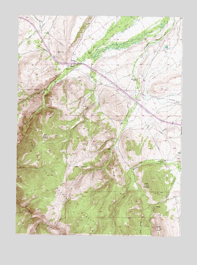
Arlington, WY USGS Topographic Map
Click on map above to begin viewing in our Map Viewer.

This topographic map contains these locations and features:
Feature Name Type Latitude Longitude GNIS ID View Map
ArlingtonPopulated PlaceN41.5947°W106.2083°1609063View Map
Arlington Census Designated PlaceCensusN41.6053°W106.1997°2629261View Map
Brokaw RanchLocaleN41.6036°W106.1922°1598382View Map
Canon DitchCanalN41.5791°W106.1475°1598605View Map
Copper King MineMineN41.6119°W106.1558°1726246View Map
Cottontail MineMineN41.5633°W106.1339°1726098View Map
Deep CreekStreamN41.5075°W106.2306°1599176View Map
Deer MountainSummitN41.5291°W106.1511°1599213View Map
Old Fisher RanchLocaleN41.5891°W106.1589°1601900View Map
Overland CreekStreamN41.5819°W106.2267°1601958View Map
Rafter Six RanchLocaleN41.5430°W106.1381°1602356View Map
Rock Creek MineMineN41.5902°W106.2222°1726099View Map
Rock Creek Picnic GroundLocaleN41.5794°W106.2300°1602591View Map
Rock Creek Valley Volunteer Fire DepartmentBuildingN41.6043°W106.2068°2673573View Map
Rock MountainSummitN41.5561°W106.2283°1602598View Map
Waterloo ProspectsMineN41.5575°W106.1878°1726097View Map
West Fork Dutton CreekStreamN41.5422°W106.1253°1604055View Map
White RanchLocaleN41.5489°W106.1781°1604143View Map
WoodedgePopulated PlaceN41.5175°W106.1456°1604284View Map

Note: Coordinates in the location and feature list above are referenced to NAD83 datum.


Copyright (C) 2008-2025 Ryan Niemi / Sunset Dynamics ... All Rights Reserved