TopoQuest Logo
Do you find TopoQuest useful?
Help keep TopoQuest running and adding new maps/features by donating!
Bitcoin:  19c7KJd3qBynnjoSw5npx9KScwjBe4ifkT
Litecoin:  LXs6TkuXGGXo1vDsWCkWVdjQX94eUKd6ui
Home View Maps Find Maps Find Places Resources & Links


Arlington, Vermont Topographic Map

USGS Map Title: Arlington, VT
USGS Map MRC: 43073A2
DRG (GeoTIFF) Download: o43073a2.tif


Neighboring USGS Topographic Map Quads:


  Salem, NY  
43073B3
 

  West Rupert, VT  
43073B2
 

  Manchester, VT  
43073B1
 

  Shushan, NY  
43073A3
 

  Arlington, VT  
43073A2
 

  Sunderland, VT  
43073A1
 

  Hoosick Falls, NY  
42073H3
 

  Bennington, VT  
42073H2
 

  Woodford, VT  
42073H1


Map MRC Location:

N44°
W74°
N44°
W73°
H8 H7 H6 H5 H4 H3 H2 H1
G8 G7 G6 G5 G4 G3 G2 G1
F8 F7 F6 F5 F4 F3 F2 F1
E8 E7 E6 E5 E4 E3 E2 E1
D8 D7 D6 D5 D4 D3 D2 D1
C8 C7 C6 C5 C4 C3 C2 C1
B8 B7 B6 B5 B4 B3 B2 B1
A8 A7 A6 A5 A4 A3 A2 A1
N43°
W74°
N43°
W73°

Arlington, VT USGS 1:24K Topographic Map Preview:
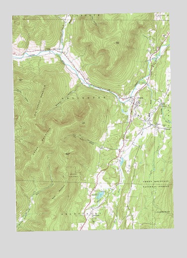
Arlington, VT USGS Topographic Map
Click on map above to begin viewing in our Map Viewer.

This topographic map contains these locations and features:
Feature Name Type Latitude Longitude GNIS ID View Map
ArlingtonPopulated PlaceN43.0748°W73.1540°1460530View Map
Arlington Census Designated PlaceCensusN43.0691°W73.1475°2378119View Map
Arlington Fire Department - East StationBuildingN43.0603°W73.1419°2121256View Map
Arlington Fire Department - West StationBuildingN43.1022°W73.2080°2121239View Map
Arlington Green Covered BridgeBridgeN43.1045°W73.2204°1920165View Map
Arlington Memorial High SchoolSchoolN43.0657°W73.1513°1920166View Map
Arlington Municipal ForestForestN43.0612°W73.1265°1920167View Map
Arlington Post OfficePost OfficeN43.0706°W73.1564°1920168View Map
Arlington Rescue SquadBuildingN43.0707°W73.1527°2578124View Map
Arlington State ForestForestN43.0320°W73.2034°1460531View Map
Arlington Town HallBuildingN43.0734°W73.1540°1920170View Map
Arlington Village Historic DistrictParkN43.0723°W73.1548°1920171View Map
Battenkill Valley Supervisory UnionSchoolN43.0648°W73.1516°2427526View Map
Beaver Meadow BrookStreamN43.0698°W73.1318°1460586View Map
Benedict HollowValleyN43.0851°W73.1957°1460599View Map
Big Spruce MountainSummitN43.0790°W73.2262°1460608View Map
Buck HillSummitN43.0881°W73.2448°1460674View Map
Camp AvalonLocaleN43.0217°W73.1787°1920208View Map
Camping on the Batten Kill CampgroundLocaleN43.0848°W73.1659°1920212View Map
ChiselvillePopulated PlaceN43.0712°W73.1346°1460722View Map
Chiselville Covered BridgeBridgeN43.0723°W73.1332°1920218View Map
Dry BrookStreamN43.0742°W73.1654°1460810View Map
Dry Brook HollowValleyN43.0470°W73.1673°1460811View Map
East ArlingtonPopulated PlaceN43.0604°W73.1407°1460821View Map
East Arlington Federated ChurchChurchN43.0601°W73.1371°1920240View Map
East Arlington Post OfficePost OfficeN43.0603°W73.1407°1920241View Map
Evergreen CemeteryCemeteryN43.0515°W73.1607°1460855View Map
Fayville BranchStreamN43.0637°W73.1443°1460867View Map
Fisher Elementary SchoolSchoolN43.0661°W73.1539°1460874View Map
Grass MountainSummitN43.0529°W73.2234°1460928View Map
Green RiverStreamN43.1020°W73.2129°1460936View Map
Grove Picnic ShelterLocaleN43.0190°W73.1815°1920272View Map
Healing Springs Nature TrailTrailN43.0198°W73.1854°1920278View Map
Hidden ValleyPopulated PlaceN43.0009°W73.1962°1920283View Map
Howells Camping AreaLocaleN43.0579°W73.1390°1920288View Map
KansasPopulated PlaceN43.0579°W73.1309°1461036View Map
Lake ShaftsburyReservoirN43.0204°W73.1824°1461388View Map
Lake Shaftsbury DamDamN43.0217°W73.1796°1766485View Map
Little Rhode Island CemeteryCemeteryN43.0190°W73.1720°1920307View Map
Maple Hill CemeteryCemeteryN43.0123°W73.1603°1920322View Map
Martha Canfield Memorial Free LibraryBuildingN43.0898°W73.1537°1920324View Map
Matteson CemeteryCemeteryN43.0568°W73.1514°1920328View Map
Millers PondReservoirN43.0390°W73.1653°1766687View Map
Millers Pond DamDamN43.0417°W73.1646°1766686View Map
Mount Pleasant SchoolSchoolN43.0590°W73.1309°1461181View Map
Peter Matteson Tavern (historical)BuildingN43.0040°W73.1571°1920376View Map
Red MountainSummitN43.1081°W73.1682°1461319View Map
Redeemer Lutheran ChurchChurchN43.0731°W73.1543°1920399View Map
Roaring BranchStreamN43.0751°W73.1407°1461337View Map
Saint James CemeteryCemeteryN43.0745°W73.1546°1920411View Map
Saint James Episcopal ChurchChurchN43.0742°W73.1546°1920413View Map
Shaftsburg State ParkParkN43.0184°W73.1871°1461828View Map
ShaftsburyPopulated PlaceN43.0087°W73.1912°1461385View Map
Shaftsbury Fire Department Station 2BuildingN43.0107°W73.1898°2121242View Map
Shaftsbury State ParkParkN43.0209°W73.1815°1920439View Map
South End CemeteryCemeteryN43.0590°W73.1366°1920448View Map
Spruce PeakSummitN43.0445°W73.2093°1461457View Map
Sunderland Elementary SchoolSchoolN43.0846°W73.1277°1920476View Map
The Arlington GalleryBuildingN43.0729°W73.1540°1920483View Map
The BallSummitN43.0623°W73.1962°1461523View Map
Topping Tavern MuseumBuildingN43.0040°W73.1571°1920481View Map
Town of ArlingtonCivilN43.0750°W73.2021°1462027View Map
Vermont Healing Springs (historical)SpringN43.0209°W73.1818°1920490View Map
Warm BrookStreamN43.0867°W73.1482°1461580View Map
West ArlingtonPopulated PlaceN43.1034°W73.2126°1461585View Map
West Arlington CemeteryCemeteryN43.1042°W73.2282°1920496View Map
West Arlington Methodist ChurchChurchN43.1037°W73.2207°1920497View Map
West MountainSummitN43.0184°W73.2196°1461595View Map
Wilder CemeteryCemeteryN43.0177°W73.1836°1460254View Map

Note: Coordinates in the location and feature list above are referenced to NAD83 datum.


Copyright (C) 2008-2024 Ryan Niemi / Sunset Dynamics ... All Rights Reserved