TopoQuest Logo
Do you find TopoQuest useful?
Help keep TopoQuest running and adding new maps/features by donating!
Bitcoin:  19c7KJd3qBynnjoSw5npx9KScwjBe4ifkT
Litecoin:  LXs6TkuXGGXo1vDsWCkWVdjQX94eUKd6ui
Home View Maps Find Maps Find Places Resources & Links


West Rupert, Vermont Topographic Map

USGS Map Title: West Rupert, VT
USGS Map MRC: 43073B2
DRG (GeoTIFF) Download: o43073b2.tif


Neighboring USGS Topographic Map Quads:


  West Pawlet, VT  
43073C3
 

  Pawlet, VT  
43073C2
 

  Dorset, VT  
43073C1
 

  Salem, NY  
43073B3
 

  West Rupert, VT  
43073B2
 

  Manchester, VT  
43073B1
 

  Shushan, NY  
43073A3
 

  Arlington, VT  
43073A2
 

  Sunderland, VT  
43073A1


Map MRC Location:

N44°
W74°
N44°
W73°
H8 H7 H6 H5 H4 H3 H2 H1
G8 G7 G6 G5 G4 G3 G2 G1
F8 F7 F6 F5 F4 F3 F2 F1
E8 E7 E6 E5 E4 E3 E2 E1
D8 D7 D6 D5 D4 D3 D2 D1
C8 C7 C6 C5 C4 C3 C2 C1
B8 B7 B6 B5 B4 B3 B2 B1
A8 A7 A6 A5 A4 A3 A2 A1
N43°
W74°
N43°
W73°

West Rupert, VT USGS 1:24K Topographic Map Preview:
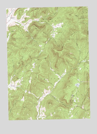
West Rupert, VT USGS Topographic Map
Click on map above to begin viewing in our Map Viewer.

This topographic map contains these locations and features:
Feature Name Type Latitude Longitude GNIS ID View Map
Baker BrookStreamN43.1923°W73.2126°1456210View Map
Bald MountainSummitN43.1887°W73.2332°1456225View Map
Barbos LakeReservoirN43.1451°W73.1479°1456249View Map
Barbos Lake DamDamN43.1454°W73.1482°1766690View Map
Bass HillSummitN43.2209°W73.1679°1456293View Map
Bear MountainSummitN43.2009°W73.1668°1456323View Map
BeartownPopulated PlaceN43.1898°W73.1296°1460394View Map
Beartown CemeteryCemeteryN43.1923°W73.1355°1920176View Map
Bennetts RidgeRidgeN43.1812°W73.2001°1456393View Map
Brown BrookStreamN43.1848°W73.2271°1456596View Map
Burnt HillSummitN43.2406°W73.1526°1456671View Map
Clark HollowValleyN43.2354°W73.2043°1456905View Map
Corbett HollowValleyN43.1873°W73.1329°1460759View Map
Devils Glen BrookStreamN43.1748°W73.2396°1457160View Map
Disciples of Christ ChurchChurchN43.2387°W73.2426°1920231View Map
Egg MountainSummitN43.2040°W73.2226°1457348View Map
Flat HillSummitN43.2373°W73.2193°1457450View Map
Frost HollowValleyN43.1901°W73.1412°1457495View Map
Hamilton HollowValleyN43.1531°W73.1871°1457705View Map
Haystack MountainSummitN43.2370°W73.1843°1457776View Map
Hooper Brook DamDamN43.1665°W73.1509°1920287View Map
Hopper BrookStreamN43.1531°W73.1871°1457889View Map
Hopper Brook DamDamN43.1506°W73.1512°1766675View Map
Hopper PondLakeN43.1504°W73.1510°1457890View Map
Kate HollowValleyN43.1895°W73.1346°1461037View Map
Kent HollowValleyN43.2351°W73.2043°1458072View Map
Kent Hollow CemeteryCemeteryN43.2281°W73.1755°1920297View Map
Lake MadeleineReservoirN43.1629°W73.1431°1766310View Map
Lake Madeleine DamDamN43.1617°W73.1446°1766309View Map
Little EquinoxSummitN43.1484°W73.1268°1458237View Map
Little Haystack MountainSummitN43.2367°W73.1948°1458238View Map
Masters MountainSummitN43.2476°W73.2040°1458377View Map
Mears HollowValleyN43.1884°W73.1340°1461136View Map
Mill BrookStreamN43.2384°W73.2493°1458461View Map
Minister HillSummitN43.1423°W73.1859°1458491View Map
Moffitt HollowValleyN43.1862°W73.1415°1458508View Map
Moffitt MountainSummitN43.1931°W73.1937°1458509View Map
Norton BrookStreamN43.1809°W73.1504°1458783View Map
Oak HillSummitN43.2467°W73.2279°1458806View Map
Oven BrookStreamN43.2181°W73.1801°1458861View Map
Pendock HillSummitN43.1317°W73.1451°1458933View Map
Pruddy BrookStreamN43.1709°W73.1679°1459095View Map
Rupert State ForestForestN43.2367°W73.1290°1461359View Map
SandgatePopulated PlaceN43.1481°W73.1990°1459366View Map
Sandgate BrookStreamN43.2298°W73.2221°1459367View Map
Sandgate Center CemeteryCemeteryN43.1516°W73.1975°1920418View Map
Sandgate Methodist ChurchChurchN43.1506°W73.1962°1920419View Map
Sandgate Town HallBuildingN43.1498°W73.1971°1920421View Map
Scott CemeteryCemeteryN43.2123°W73.2056°1920423View Map
Shatterack MountainSummitN43.2248°W73.1979°1459463View Map
Sherman Homestead CemeteryCemeteryN43.1815°W73.2118°1920440View Map
Spruce PeakSummitN43.2398°W73.1409°1459655View Map
Spruce Swamp (historical)SwampN43.1626°W73.1432°1920456View Map
Swearing HillSummitN43.1387°W73.2234°1459803View Map
Tate MountainSummitN43.1504°W73.2457°1459825View Map
The Big RidgeRidgeN43.2265°W73.2298°1459844View Map
The NotchGapN43.1565°W73.2212°1459878View Map
The OvenBasinN43.2073°W73.1712°1459881View Map
The Ox BowSummitN43.2259°W73.2054°1459882View Map
Tidd HollowValleyN43.1279°W73.1946°1461545View Map
Town of SandgateCivilN43.1688°W73.1971°1462201View Map
Walnut HillSummitN43.1712°W73.2359°1460054View Map
West End - Camdon Valley CemeteryCemeteryN43.1623°W73.2396°1920499View Map
West RupertPopulated PlaceN43.2387°W73.2429°1460168View Map
West Rupert CemeteryCemeteryN43.2359°W73.2455°1920500View Map
West Rupert Post OfficePost OfficeN43.2392°W73.2431°1920501View Map
West SandgatePopulated PlaceN43.1629°W73.2459°1460171View Map
Wilcox CemeteryCemeteryN43.1420°W73.1440°1920504View Map
Wilcox HollowValleyN43.1617°W73.1790°1460250View Map
Youlin HollowValleyN43.2356°W73.2315°1920516View Map

Note: Coordinates in the location and feature list above are referenced to NAD83 datum.


Copyright (C) 2008-2024 Ryan Niemi / Sunset Dynamics ... All Rights Reserved