TopoQuest Logo
Do you find TopoQuest useful?
Help keep TopoQuest running and adding new maps/features by donating!
Bitcoin:  19c7KJd3qBynnjoSw5npx9KScwjBe4ifkT
Litecoin:  LXs6TkuXGGXo1vDsWCkWVdjQX94eUKd6ui
Home View Maps Find Maps Find Places Resources & Links


Eunice, Texas Topographic Map

USGS Map Title: Eunice, TX
USGS Map MRC: 31095C7
DRG (GeoTIFF) Download: o31095c7.tif


Neighboring USGS Topographic Map Quads:


  Flo, TX  
31095D8
 

  Lake Leon, TX  
31095D7
 

  Stanmire Lake, TX  
31095D6
 

  Centerville, TX  
31095C8
 

  Eunice, TX  
31095C7
 

  Halls Bluff, TX  
31095C6
 

  Leona, TX  
31095B8
 

  Middleton, TX  
31095B7
 

  Austonio, TX  
31095B6


Map MRC Location:

N32°
W96°
N32°
W95°
H8 H7 H6 H5 H4 H3 H2 H1
G8 G7 G6 G5 G4 G3 G2 G1
F8 F7 F6 F5 F4 F3 F2 F1
E8 E7 E6 E5 E4 E3 E2 E1
D8 D7 D6 D5 D4 D3 D2 D1
C8 C7 C6 C5 C4 C3 C2 C1
B8 B7 B6 B5 B4 B3 B2 B1
A8 A7 A6 A5 A4 A3 A2 A1
N31°
W96°
N31°
W95°

Eunice, TX USGS 1:24K Topographic Map Preview:
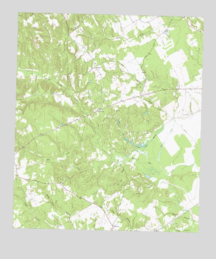
Eunice, TX USGS Topographic Map
Click on map above to begin viewing in our Map Viewer.

This topographic map contains these locations and features:
Feature Name Type Latitude Longitude GNIS ID View Map
Beaver Dam CemeteryCemeteryN31.3288°W95.8505°1351730View Map
Beaver Dam MarshSwampN31.3011°W95.7872°1351732View Map
Black BranchStreamN31.2966°W95.7922°1352289View Map
CenterviewPopulated PlaceN31.2527°W95.8077°2034934View Map
CenterviewLocaleN31.2524°W95.8077°1354215View Map
Dillard Ranch AirportAirportN31.3114°W95.7890°1386365View Map
Dixon CreekStreamN31.3063°W95.7725°1356086View Map
EunicePopulated PlaceN31.3193°W95.8183°1379739View Map
Fort Bend County Law LibraryBuildingN31.3099°W95.7613°2014945View Map
Fort Bend County LibrariesBuildingN31.3396°W95.7583°2014946View Map
Hayes BranchStreamN31.2510°W95.7558°1358933View Map
HopewellPopulated PlaceN31.3443°W95.8213°1379957View Map
Hurricane CreekStreamN31.2830°W95.7583°1383111View Map
KBHT-FM (Crockett)TowerN31.3343°W95.7872°1385832View Map
Mill CreekStreamN31.3005°W95.8183°1362871View Map
Pine CreekStreamN31.2860°W95.7752°1365272View Map
Red Oak HollowValleyN31.2887°W95.8004°1366198View Map
Tubb LakeReservoirN31.2902°W95.8502°1859057View Map
Tubb Lake DamDamN31.2902°W95.8502°1859056View Map
Victory ChurchChurchN31.3191°W95.8175°1370638View Map

Note: Coordinates in the location and feature list above are referenced to NAD83 datum.


Copyright (C) 2008-2025 Ryan Niemi / Sunset Dynamics ... All Rights Reserved