TopoQuest Logo
Do you find TopoQuest useful?
Help keep TopoQuest running and adding new maps/features by donating!
Bitcoin:  19c7KJd3qBynnjoSw5npx9KScwjBe4ifkT
Litecoin:  LXs6TkuXGGXo1vDsWCkWVdjQX94eUKd6ui
Home View Maps Find Maps Find Places Resources & Links


Stanmire Lake, Texas Topographic Map

USGS Map Title: Stanmire Lake, TX
USGS Map MRC: 31095D6
DRG (GeoTIFF) Download: o31095d6.tif


Neighboring USGS Topographic Map Quads:


  Oakwood, TX  
31095E7
 

  Indian Lake, TX  
31095E6
 

  Elkhart Creek, TX  
31095E5
 

  Lake Leon, TX  
31095D7
 

  Stanmire Lake, TX  
31095D6
 

  Hays Spring, TX  
31095D5
 

  Eunice, TX  
31095C7
 

  Halls Bluff, TX  
31095C6
 

  Porter Springs, TX  
31095C5


Map MRC Location:

N32°
W96°
N32°
W95°
H8 H7 H6 H5 H4 H3 H2 H1
G8 G7 G6 G5 G4 G3 G2 G1
F8 F7 F6 F5 F4 F3 F2 F1
E8 E7 E6 E5 E4 E3 E2 E1
D8 D7 D6 D5 D4 D3 D2 D1
C8 C7 C6 C5 C4 C3 C2 C1
B8 B7 B6 B5 B4 B3 B2 B1
A8 A7 A6 A5 A4 A3 A2 A1
N31°
W96°
N31°
W95°

Stanmire Lake, TX USGS 1:24K Topographic Map Preview:
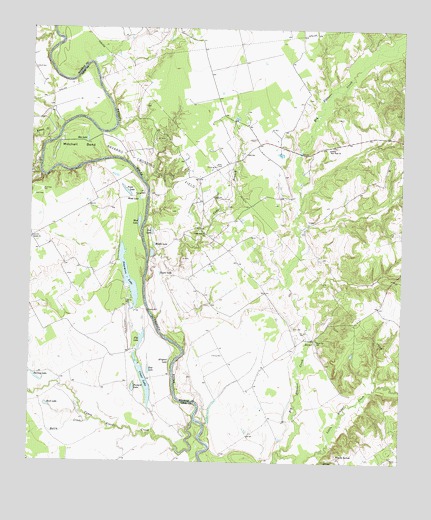
Stanmire Lake, TX USGS Topographic Map
Click on map above to begin viewing in our Map Viewer.

This topographic map contains these locations and features:
Feature Name Type Latitude Longitude GNIS ID View Map
Alligator LakeLakeN31.4041°W95.7024°1351021View Map
Ben LakeLakeN31.4680°W95.7315°1351868View Map
Bluff CemeteryCemeteryN31.4882°W95.7491°1352506View Map
Buzzard LakeLakeN31.3968°W95.7149°1353449View Map
Cedar BranchStreamN31.4274°W95.7113°1354038View Map
Cedar Branch ChurchChurchN31.4407°W95.6916°1354040View Map
Chiles BranchStreamN31.4230°W95.6605°1377406View Map
Clear LakeLakeN31.3983°W95.7114°1354636View Map
Field LakeLakeN31.4533°W95.7180°1357305View Map
Flat LakeLakeN31.4110°W95.7127°1357434View Map
Gin LakeLakeN31.4414°W95.7094°1358037View Map
Greater New Hope ChurchChurchN31.4657°W95.6502°1358365View Map
Haley CreekStreamN31.3874°W95.7288°1373978View Map
Kent HillSummitN31.4121°W95.6525°1377410View Map
Kinnon CreekStreamN31.4674°W95.7444°1374387View Map
Little Elkhart CreekStreamN31.3777°W95.6669°1361345View Map
Meriwether BranchStreamN31.4288°W95.6330°1377405View Map
Middle LakeLakeN31.4378°W95.7085°1362734View Map
Mitchell BendBendN31.4641°W95.7380°1362983View Map
Mud LakeLakeN31.4443°W95.7136°1363409View Map
Murchison BranchStreamN31.4935°W95.6288°1363492View Map
Navarro Crossing Oil FieldOilfieldN31.4596°W95.7061°1375098View Map
Old Dailey Family CemeteryCemeteryN31.4804°W95.6563°1377409View Map
Perring LakeLakeN31.3989°W95.7473°1365072View Map
ReynardPopulated PlaceN31.4105°W95.6547°1380434View Map
Sand Flat SchoolSchoolN31.4105°W95.6533°1367599View Map
Sand LakeLakeN31.3914°W95.7442°1367623View Map
Shiloh ChurchChurchN31.4396°W95.7500°1368166View Map
Stanmire LakeLakeN31.4286°W95.7171°1369099View Map
Taylor LakeLakeN31.4292°W95.7065°1369648View Map
Upper Keechi CreekStreamN31.3871°W95.6941°1376557View Map
W C Ranch AirportAirportN31.4766°W95.6350°1386763View Map
Wes Hicks CemeteryCemeteryN31.4797°W95.6568°1377404View Map
Wheeler SpringsPopulated PlaceN31.3768°W95.6466°1380766View Map
Wood LakeLakeN31.4508°W95.7136°1371894View Map
Zeke LakeLakeN31.4018°W95.7099°1372085View Map

Note: Coordinates in the location and feature list above are referenced to NAD83 datum.


Copyright (C) 2008-2025 Ryan Niemi / Sunset Dynamics ... All Rights Reserved