TopoQuest Logo
Do you find TopoQuest useful?
Help keep TopoQuest running and adding new maps/features by donating!
Bitcoin:  19c7KJd3qBynnjoSw5npx9KScwjBe4ifkT
Litecoin:  LXs6TkuXGGXo1vDsWCkWVdjQX94eUKd6ui
Home View Maps Find Maps Find Places Resources & Links


Centerville, Texas Topographic Map

USGS Map Title: Centerville, TX
USGS Map MRC: 31095C8
DRG (GeoTIFF) Download: o31095c8.tif


Neighboring USGS Topographic Map Quads:


  Buffalo, TX  
31096D1
 

  Flo, TX  
31095D8
 

  Lake Leon, TX  
31095D7
 

  Robbins, TX  
31096C1
 

  Centerville, TX  
31095C8
 

  Eunice, TX  
31095C7
 

  Spring Seat, TX  
31096B1
 

  Leona, TX  
31095B8
 

  Middleton, TX  
31095B7


Map MRC Location:

N32°
W96°
N32°
W95°
H8 H7 H6 H5 H4 H3 H2 H1
G8 G7 G6 G5 G4 G3 G2 G1
F8 F7 F6 F5 F4 F3 F2 F1
E8 E7 E6 E5 E4 E3 E2 E1
D8 D7 D6 D5 D4 D3 D2 D1
C8 C7 C6 C5 C4 C3 C2 C1
B8 B7 B6 B5 B4 B3 B2 B1
A8 A7 A6 A5 A4 A3 A2 A1
N31°
W96°
N31°
W95°

Centerville, TX USGS 1:24K Topographic Map Preview:
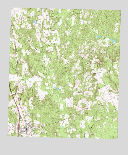
Centerville, TX USGS Topographic Map
Click on map above to begin viewing in our Map Viewer.

This topographic map contains these locations and features:
Feature Name Type Latitude Longitude GNIS ID View Map
African ChurchChurchN31.3135°W95.9041°1350901View Map
Alton LakeReservoirN31.3299°W95.9923°1864219View Map
Alton Lake DamDamN31.3268°W95.9919°1864218View Map
Bain BranchStreamN31.2649°W95.9772°1351421View Map
Cattail BranchStreamN31.2641°W95.9752°1353984View Map
CentervillePopulated PlaceN31.2580°W95.9783°1354216View Map
Centerville City OfficesBuildingN31.2573°W95.9766°2754014View Map
Centerville DivisionCivilN31.2539°W95.8816°1938614View Map
Centerville Post OfficePost OfficeN31.2584°W95.9767°2731340View Map
Centerville Volunteer Fire DepartmentBuildingN31.2579°W95.9738°2552279View Map
City of CentervilleCivilN31.2581°W95.9797°2409424View Map
Cundiff LakeReservoirN31.3172°W95.9472°1859061View Map
Cundiff Lake DamDamN31.3168°W95.9469°1859060View Map
Hale BranchStreamN31.3060°W95.9891°1358636View Map
Henry Thomas BranchStreamN31.2874°W95.9444°1359046View Map
Hopewell ChurchChurchN31.2618°W95.9933°1359550View Map
Leon CountyCivilN31.2965°W95.9957°1383930View Map
Leon County JailBuildingN31.2583°W95.9761°2738687View Map
Leon County Sheriff's OfficeBuildingN31.2583°W95.9744°2739316View Map
Long BranchStreamN31.3141°W95.9908°1361709View Map
MidwayPopulated PlaceN31.3674°W95.9555°1380191View Map
Mill BranchStreamN31.3077°W95.9738°1362853View Map
Moore LakeReservoirN31.3613°W95.9734°1859059View Map
Moore Lake DamDamN31.3602°W95.9719°1859058View Map
Parks BranchStreamN31.2757°W95.9361°1364843View Map
Pleasant SpringsPopulated PlaceN31.3149°W95.9016°1380378View Map
Spring BranchStreamN31.2907°W95.9519°1368934View Map
Texas Medical ResponseBuildingN31.2593°W95.9805°2656139View Map
Tiger BranchStreamN31.3049°W95.9872°1369929View Map

Note: Coordinates in the location and feature list above are referenced to NAD83 datum.


Copyright (C) 2008-2024 Ryan Niemi / Sunset Dynamics ... All Rights Reserved